 Keer 1605

|

|
|
|
item:- Dove Cottage : 2007.38.110 image:- © see bottom of page |
click to enlarge |
|
|
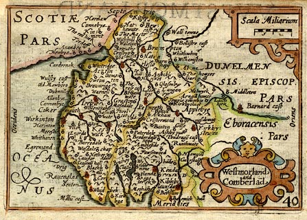
Map, hand coloured engraving, Westmorland and Cumberland,
scale about 16 miles to 1 inch, probably by Pieter van den
Keere, or Peter Keer, about 1605 edition perhaps 1676.
Included in England Wales Scotland and Ireland Described and Abridged ... from John Speed. The map title is translated from Latin; there is text on the reverse in English, part of the description of the county, abridged from Speed's atlas of 1611. The typesetting of the text differs from other editions of the map, only a check of an original atlas will sort this data. |
||

|
Keer 1605 | |
| map feature:- | strapwork cartouche & labelled borders & up is N & scale line & sea moire effect & coast shaded & rivers & lakes & relief & hillocks & county & settlements | |
| inscription:- |
printed title cartouche, lower right
Westmorland / and / Cumberland |
|
| scale line:- | 10 miles = 15.3 mm | |
| scale:- | 1 to 1100000 ? (1 to 1051819 from scale line) | |
| wxh, sheet:- | 17x11cm (roughly) | |
| wxh, map:- | 123x84mm | |
|
||
|
|
notes | |