 Bill 1626

|

|
|
|
item:- Armitt Library : ALMC2008.14.66 image:- © see bottom of page |
click to enlarge |
|
|
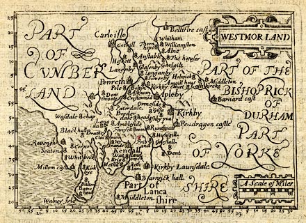
Map, uncoloured engraving, Westmor Land ie Westmorland,
scale about 17 miles to 1 inch, by John Bill, London, 1626.
Included in The Abridgement of Camden's Britannia. There is descriptive text on the reverse for Lancashire. Derived from the map by Peter Keer 1605. |
||

|
Bill 1626 | |
| map feature:- | strapwork cartouche & swash lettering & up is N & scale line & lat and long scales (from the E) & sea moire effect & coast shaded & rivers & lakes & relief & hillocks & county & settlements | |
| inscription:- |
printed title cartouche, upper right
WESTMOR LAND |
|
| inscription:- |
printed above scale line
A Scale of Miles |
|
| scale line:- | 15 miles = 22.7 mm | |
| longitude, Kendal:- | 24d 53m E (approx) | |
| wxh, sheet:- | 19x14cm | |
| wxh, map:- | 121x84mm | |
| scale:- | 1 to 1100000 ? (1 1063443 to from scale line wrongly assuming a statute mile) | |
|
|
notes | |