 Unknown 1814

|

|
|
|
item:- JandMN (164) image:- © see bottom of page |
click to enlarge |
|
|
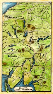
Map, hand coloured engraving, Plan of the Lakes of
Cumberland, scale about 9 miles to 1 inch, perhaps about
1814.
Despite the title the lakes in Westmorland, Cumberland, and Lancashire are shown. The colouring is late and amateurish, pity. |
||

|
Unknown 1814 | |
| map feature:- | plain cartouche & up is N & coast form lines & rivers & lakes & relief & hill hachuring & settlements & roads & canals | |
| inscription:- |
printed title cartouche, lower left
Plan of The / LAKES of CUMBERLAND |
|
| wxh, sheet:- | 11x18.5cm | |
| wxh, map:- | 89x159mm | |
| scale:- | 1 to 560000 ? (rough estimate) | |
|
|
notes | |