 Unknown 1814

|

|
|

|
back to object record | |
| MAP FEATURES | ||
|
|
||
| title |
Printed in a plain cartouche, lower left:-
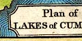
Plan of The LAKES of CUMBERLAND The map is of the Lake District and includes lakes in Westmorland and Lancashire as well. |
|
|
|
||
|
orientation
up is NE |
There is no indicator for orientation. The map is printed
with NNE at the top of the sheet, roughly.
|
|
|
|
||
| scale |
No indicator of scale is provided. An estimate gives a
map scale is about:-
1 to 560000 9 miles to 1 inch |
|
|
|
||
|
sea area
sea tinted |
The sea area is tinted blue, and is overrun with the
coast form lines.
|
|
|
|
||
|
coast line
coast form lines |
The coast line is emphasized by form lines. |
|
|
|
||
| rivers |
Rivers are drawn by wiggly lines tapering upstream. A
couple of rivers are labelled, eg:-
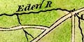
Eden R [running into the sea at Maryport, River Ellen] Caldow R Some other rivers are labelled in their estuaries, eg:- River Kent It is possible to recognize some other rivers, but beware interesting mapping like the river connecting Grasmere lake to Thirlmere, up over the Raise Gap. The Raise Beck here has been managed artificially to flow both ways, but not in 1814. |
|
|
|
||
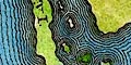
| lakes |
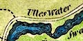
Lakes are drawn in outline with form lines, tinted blue. Some lakes are labelled:- Bassenthwaite W Burnmoor Tarn Buttermere Coniston W. Crommaw Derwent Devock Lake Ennerdale W Haws Water Leaths Water [Thirlmere] Lowes W. Ulles Water Wast Water Windermere Other lakes or tarns might be recognized, eg:- Brothers Water Easedale Tarn Esthwaite Water [and Priest Pot?] Grasmere lake Kentmere tarn Over Water (?) Rydal Water Skeggles Water Windermere is drawn as two lakes contiguous to each other at Bowness. Islands are shown in Derwent Water. |
|
|
|
||
|
relief
hill hachuring |
A very little relief is suggested by hill hachuring, the
hills tinted pale brown. Most of the land area is tinted
green. Some of the hills are labelled, eg:-
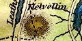
Helvellin Skiddow H Bell [Ill Bell] ... while Scafell is not even indicated. |
|
|
|
||
| county |
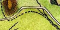
County boundaries are a dashed line. Notice that the boundary entering and going along Ullswater is much as it is now. Windermere is mostly included in Westmorland, but the foot is cut out of that county. The border with Lancashire west of Wrynose is missing. County areas are not labelled. |
|
|
|
||
| wards |
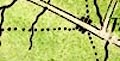
There are fine dotted line boundaries which might delimit wards - not checked. |
|
|
|
||
| settlements |
A few settlements, providing points to make sense of
routes, are marked by groups of blocks. While a few places
are distinguished by having upright rather than italic
labelling, there is not reliable differentiation of
importance of place. Most, if not all, places shown are
towns.
|
|
|
cities
towns |
group of blocks; labelled in italic lowercase text,
eg:-

Kendal Ambleside |
|
|
|
||
|
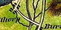
roads
sands roads |
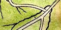
A network of roads is drawn by double lines. The sands roads are not shown, but notice the road across the Cartmel peninsula and the road to the canal foot below Ulverston, and the roads either side of the Duddon Estuary, all suggesting the routes across the sands. |
|
|
|
||
| canals |
The Lancaster Canal is drawn by a double line, tinted grey. |
|
Lakes Guides menu.