 Plan of the Lakes of Cumberland

|

|
|
|
map type:- Unknown 1814 |
|
|
|
Map, Plan of the Lakes of Cumberland, perhaps about 1814.
Despite the title the lakes in Westmorland, Cumberland, and Lancashire are shown. |
||
|
(example JandMN (164))
|
||
| map feature:- | title cartouche & plain cartouche & up is N & coast form lines & rivers & lakes & relief & hill hachuring & settlements & roads & canals | |
| inscription:- |
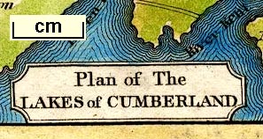
printed title cartouche, lower left
Plan of The / LAKES of CUMBERLAND |
|
| wxh, sheet:- | 11x18.5cm | |
| wxh, map:- | 89x159mm | |
| sources:- |
JandMN Collection |
|
| items seen (illustrated items in bold):- | ||

|
JandMN (164) -- map -- Plan of the Lakes of Cumberland | |