 Postlethwaite 1877 map 1

|

|
|
|
item:- JandMN (162_1) image:- © see bottom of page |
click to enlarge |
|
|
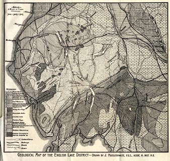
Geological map, uncoloured engraving, Geological Map of
the English Lake District, scale about 5 miles to 1 inch, by
John Postlethwaite, published by W H Moss and Sons, 13
Lowther Street, Whitehaven, Cumberland, 1877 edn 1913.
Folded and tipped in before p.1 of Mines and Mining in the English Lake District. |
||

|
Postlethwaite 1877 map 1 | |
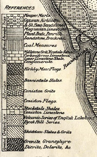
| map feature:- | table of symbols & up is N & scale line & sea plain & coast form lines & rivers & lakes & settlements & roads & railways & geology & stratigraphical column | |
| inscription:- |
printed bottom
GEOLOGICAL MAP OF THE ENGLISH LAKE DISTRICT - DRAWN BY J. POSTLETHAITE, F.G.S., ASSOC. M. INST.M.E. |
|
| inscription:- |
printed above scale line
SCALE / 5 MILES TO 1 INCH. |
|
| scale line:- | 5 miles = 24.9 mm | |
| scale:- | 1 to 320000 ? (1 to 323161 from scale line) | |
| wxh, sheet:- | 28.528cm | |
| wxh, map:- | 270x248mm | |
|
||