 Geological Map of the English Lake District

|

|
|
|
map type:- Postlethwaite 1877 map 1 |

|
|
|
Geological Map of the English Lake District, scale about
5 miles to 1 inch, by John Postlethwaite, 1877.
The geological areas are not coloured but printed in black and white by various shadings, hatchings, dottings, etc. Included in Mines and Mining in the English Lake District, by John Postlethwaite, published by W H Moss and Sons, Whitehaven, Cumberland now Cumbria, 1877-1913. |
||
|
(map example )
|
||
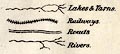
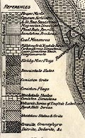
| map feature:- | up is N & scale line & table of symbols & sea plain & coast form lines & rivers & lakes & relief & hill hachuring (a little) & settlements (few) & railways & roads & geology & table of strata | |
| inscription:- |
printed bottom
GEOLOGICAL MAP OF THE ENGLISH LAKE DISTRICT - DRAWN BY J. POSTLETHWAITE, F.G.S., ASSOC.M.INST.M.E. |
|
| inscription:- |
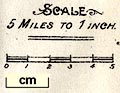
printed above scale line
SCALE / 5 MILES TO 1 INCH. |
|
| scale line:- | 5 miles = 24.9 mm | |
| scale:- | 1 to 320000 ? (1 to 323161 from scale line) | |
| wxh, sheet:- | 28.5x28cm | |
| wxh, map:- | 272x250mm | |
|
||
|
||
|
||
| references:- |
: 1975: Postlethwaite's Mines and Mining in the English Lake
District: Moon, Michael (Beckermet, Cumbria):: ISBN 0 904131
10 6 |
|
| sources:- |
Armitt Library JandMN Collection |
|
| items seen (illustrated items in bold):- | ||

|
JandMN (162_1) -- geological map -- Geological Map of the English Lake District | |