 Harrison 1790

|

|
|
|
item:- Armitt Library : ALMC2008.14.99 image:- © see bottom of page |
click to enlarge |
|
|
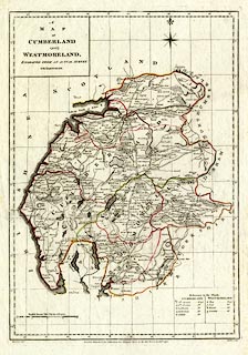
Map, hand coloured engraving, Cumberland and
Westmoreland, scale about 6 miles to 1 inch, drafted by
Haywood, engraved by Sudlow, 1790, published by John
Harrison, 115 Newgate Street, London, 1791-12.
included in Maps of the English Counties with the Subdivisions of Hundreds, Wapontakes, Lathes, Wards, Divisions, &c. |
||

|
Harrison 1790 | |
| map feature:- | plain cartouche & compass rose & up is N & scale line & lat and long scales (rectangular projection) & lat and long grid & coast form lines & rivers & lakes & relief & hill hachuring & woods & forests & parks & county & wards & table of wards & settlements & roads | |
| inscription:- |
printed upper left
A / MAP / OF / CUMBERLAND / AND / WESTMORELAND, / ENGRAVED FROM AN ACTUAL SURVEY / with Improvements. |
|
| inscription:- |
printed bottom, left, right, centre
Haywood del. / Sudlow Sculp. / London, Engraved for J. Harrison, 115, Newgate Street, as the Act directs, 13, Jany. 1790. |
|
| inscription:- |
printed above scale line
English Statute Miles 69 1/2 to a Degree. |
|
| scale line:- | 20 miles = 86.0 mm | |
| longitude, Kendal:- | 2d 51m W | |
| wxh, sheet:- | 41x54cm | |
| wxh, plate:- | 328x474mm | |
| wxh, map:- | 323x462mm | |
| scale:- | 1 to 3700000 ? (1 to 374266 from scale line assuming a statute mile) | |
|
|
notes | |