 Harrison 1790

|

|
|

|
back to object record | |
| MAP FEATURES | ||
|
|
||
|
title cartouche
plain cartouche |
Printed upper left in a plain cartouche:-
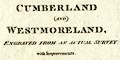
A MAP OF CUMBERLAND AND WESTMORELAND, ENGRAVED FROM AN ACTUAL SURVEY with Improvements. Printed bottom, left, right, centre:- Haywood del. / Sudlow Sculp. / London, Engraved for J. Harrison, 115, Newgate Street, as the Act directs, 13, Jany. 1790. |
|
|
|
||
|
orientation
compass rose up is N |
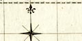
Printed upper right, orientated with the latitude longitude grid is a compass rose; shaded arrow points for cardinal directions, lines for half cardinal directions, North marked by a fleur de lys spear point. The map is printed with North at the top of the sheet. |
|
|
|
||
|
scale line
scale |
Printed lower left is a scale of:-
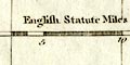
English Statute Miles 69 1/2 to a Degree. chequered in miles to 5, then in 5 mile intervals; marked at 5 mile intervals. The scale line of 20 miles = 86.0 mm, giving a scale 1 to 374266, the map scale is about:- 1 to 3700000 6 miles to 1 inch |
|
|
|
||
|
lat and long scales
lat and long grid |
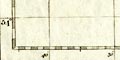
Printed in the map borders are scales of latitude and longitude for a trapezoidal projection; chequered in minutes, marked at 10 minutes intervals. The map has a latitude and longitude grid, a graticule, at 10x10 minutes. The map includes from 2d 0m to 3d 45m W, from 53d 57m to 55d 26m N; the whole of Cumberland and Westmorland. Measuring from the scales the:- longitude, Kendal: 2d 51m W implying a prime meridian 6 minutes E of Greenwich - if it is assumed there are no errors. |
|
|
|
||
|
sea area
sea plain |
The sea area is plain. Some sea areas are labelled,
eg:-
IRISH SEA Solway Frith or Eden R. |
|
|
|
||
|
coast line
coast form lines headlands |
The coast line is emphasized by form lines. One headland is noticed:- St. Bees Hd. |
|
|
|
||
|
rivers
bridges |
Rivers are drawn by a wiggly line tapering upstream. A larger estuary has form lines, and the lower part of large rivers might be a double line with ?stream lines. A few rivers are labelled, eg:- Leven R. [River Lyne not the Leven] Belo R. [River Belah] Large rivers are not particularly noticed in the labelling. Bridges are not much noticed, though they might be implied by a road crossing and interrupting a stream. A bridge, might, rarely, be labelled, eg:- 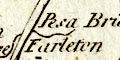
Pesa Bridge Levensbridge Near the River Kent, near Levens, is:- Waterfall but it is not clear which fall in this area is meant. |
|
|
|
||
| lakes |
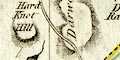
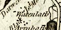
Lakes are drawn in outline, the shore line emphasized by form lines. The following lakes are labelled:- Broad Water [Ennerdale Water] Broad Water [Hawes Water] Coniston Mere Darwent Water Devock Lake Ulles Water Wiborn Water [Thirlmere] Winander Mere The following might be recognized, making allowances for poor outlines:- Bassenthwaite Lake Brothers Water Burnmoor Tarn [perhaps, but shown S of Hard Knott] Buttermere lake Crummock Water Easedale Tarn (?) Grasmere lake Hayes Water Loweswater lake Rydal Water Wast Water Besides unreliable outlines, the connectivity of lakes and rivers should not be relied upon. |
|
|
|
||
|
relief
hill hachuring |
There is some suggestion of relief by hill hachuring. It appears to be mostly imagination. A few hills are labelled, eg:- Dent Hill [by Egremont] Darwent Fell Mountains Helvillon H. Wry Nose Hd. Overall, there is no reliable representation or suggestion of the shape of the Lakes mountains. |
|
|
|
||
|
woods
forests |
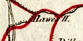
Woodland is indicated by groups of tree and bush symbols.
Some forests, and a wood, are labelled, eg:-
Mollerstang Forest Stainmore Forest Fawsett Wood Forests are shown densely wooded; mostly they aren't. |
|
|
|
||
| parks |
Parks are drawn in outline, with fence palings, the
interior with small tree or bush symbols. Some parks are
labelled, eg:-
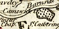
Cunswick P. Barton Park and some others might be recognized. |
|
|
|
||
| county |
County boundaries are a dashed line, with a tint. The
tints belong to both county and ward boundaries are a
confusion of colours. While the whole county boundaries have
not been checked it is worth noting that Windermere lake is
excluded from Westmorland, placed in Lancashire; and the
Cumberland Westmorland boundary is drawn along the shore of
Ullswater instead of down the middle.
The county areas are labelled:- 
WESTMORELAND CUMBERLAND and parts of adjoining counties are labelled, eg:- LANCASHIRE in the same lettering but unshaded. There are some features on the county boundaries. Labelled, but not drawn at the meet of Westmorland, Yorkshire and Lancashire is the:- County Stone Not marked, near the Lancashire border and the Lancaster Kendal road is the:- Birkstone A series of crags drawn and labelled on the north east boundary are:- Christinburg Cragg Gel Cragg Lancaster Cragg Three standing stones are drawn and labelled at the meet of Westmorland, Cumberland, and Lancashire:- 3 Shire Stones upon Wry Nose Hd. |
|
|
|
||
|
wards
table of wards |
The ward (hundred) boundaries are a fine dotted line, tinted red, but the tinting shares its function with county boundaries, and is confusing. The ward areas are labelled with a number which keys to a:- Reference to the Wards ... WESTMORELAND 6 West ... Ward 7 East ... Ward ... |
|
|
|
||
| settlements |
Settlements are marked by a block, blocks or groups of
blocks, differentiated by style of labelling.
|
|
| cities |
groups of blocks along roads; labelled in upright block
caps, eg:-
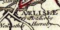
CARLISLE The layout is not a reliable street plan. |
|
| towns |
blocks or groups of blocks; labelled in upright lowercase
text, eg:-
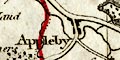
Appleby Cockermouth The latter is the de jure county town of Westmorland, but the de facto county town is labelled in upright block caps:- KENDAL |
|
|
villages
hamlets |
a block; labelled in italic lowercase text, eg:-
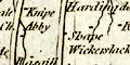
Shape [Shap] Gt. Orton Mosedale L. Musgrave |
|
|
castles
houses |
Blocks are used to mark all sorts of features including
castles and houses, which might then be labelled, eg:-
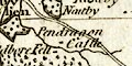
Pendragon Castle Drumborough Cast. Dalton H. Or the label might be placed without any marker. |
|
|
|
||
| roads |
A network of roads is drawn by double lines, broader or narrower; the broad having light bold lines. The general quality of the mapping does not encourage the use of time in analysis of the routes shown. Roads are not joined up across Lancashire north of the sands to the SW part of Cumberland. The Lancaster Kendal route is drawn through Burton; the alternative through Milnthorpe is drawn from near Farleton, not from a junction near the county boundary. An alternative route for Kendal to Shap is drawn as a major road through Longsleddale, over Gatescarth Pass, through Bampton to Askham, where it stops. |
|
|
|
||
| miscellaneous | ||
|
|
||
|
antiquities
earthworks |
Labelled S of the river near Penrith is:-
K. Arthurs Round T. |
|
|
|
||
|
antiquities
roman wall |
Hadrian's Wall is drawn by a double line with upright
?fence lines, from Bowness-on-Solway, through Carlisle, then
eastwards into Northumberland, labelled:-
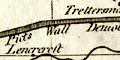
Picts Wall Demolished |
|
|
|
||
|
antiquities
roman road |
The:-
Maiden Way is drawn by a double line from near Gilsland to cross the county boundary W of Christianbury Crag. |
|
|
|
||
| stones |
The Three Shire Stones, County Stone, and:-
Dunmail Raise Stones are labelled. And there is a label for a:- Stone Heap by the Orton road off the Kendal Shap road. |
|
|
|
||
|
mines
lead mines |
Five spots mark:-
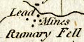
Lead Mines on the fell NW of Brough. |
|
|
|
||
|
mines
black lead mines |
SW of Keswick is:-
Black Ld Mines marked by three spots. |
|
|
|
||
| religious houses |
Labelled S of Knipe, E of Shap, is:-
Abby for Shap Abbey |
|
|
|
||
| spas |
There is a label for:-
Grisland Spaw ie Gilsland Spa. |
|
|
|
||
| mosses |
Two mosses are noticed. N of Aldby is:-
Peat Moss and N of Penrith:- The Moss and partly covered with bushes is:- 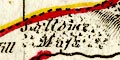
Sollome Moss |
|
| Problems | ||
|
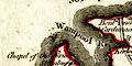
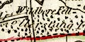
Notice the relative positions of Longtown, Netherby and
Arthuret, from N to S in that order. Netherby is N of
Longtown.
|
||
|
Notice the placename:-
|
||
|
Runny
|
||
|
for Nunnery.
|
||
|
Both these errors occur on other maps and might be a clue to
who was copied to make this map, which doesn't seem to have
been actually surveyed, or improved.
|
||
Lakes Guides menu.