 Dawson 1830s

|

|
|
|
item:- JandMN (213) image:- © see bottom of page |
click to enlarge |
|
|
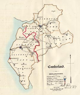
Map, hand coloured lithograph, Cumberland, scale about
6.5 miles to 1 inch, showing the proposed parliamentary
divisions, made for the Reform Bill 1832, by Lieut Robert K
Dawson RE, 1831, perhaps copied 1937?
Lithographed by R Martin, London; shows proposed division of the county, principal places of county election, boroughs returning 2 members and 1 member. This is probably a copy from the Report of the Municipal Corporation Boundaries Commission, 1937. |
||

|
Dawson 1830s | |
| map feature:- | county & wards (hundreds) & roads & settlements & scale line & north point & table of symbols & electoral data | |
| inscription:- |
printed lower right
Cumberland. english black letter |
|
| inscription:- |
printed ms lower right
Robt. K. Dawson, / Lieut. R.E. |
|
| inscription:- |
printed lower right
C. Ingrey, Lithog. 340, Strand. |
|
| scale line:- | 10 miles = 37.9 mm | |
| scale:- | 1 to 420000 ? (1 to 424629 from scale line) | |
| wxh, sheet:- | 33.5x34.5cm | |
|
|
notes | |