 Dawson 1830s

|

|
|

|
back to object record | |
| MAP FEATURES | ||
|
|
||
|
title
map maker engraver |
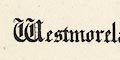
Westmorland:- Printed upper left in english black letter:- Westmoreland. Printed ms lower right:- Robt. K. Dawson, Lieut. R.E. Printed lower left below the scale line:- R. Martin, lithog. 124, High Holborn & 51, Carey St. Cumberland:- Printed lower right in english black letter:- Cumberland. Printed ms lower right:- Robt. K. Dawson, Lieut. R.E. Printed lower right:- C. Ingrey, Lithog. 340, Strand. |
|
|
|
||
| table of symbols |
Each map has a table of symbols. That for Cumberland is
more complete:-
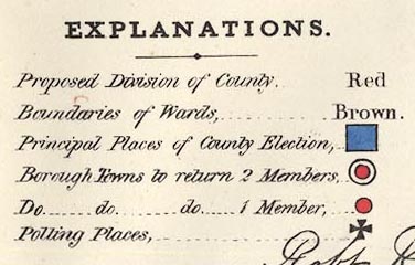
EXPLANATIONS. Proposed Division of County, ... Red Boundaries of Wards, ... Brown Principal Places of County Election, ... [square, tinted blue] Borough Towns to return 2 Members, ... [double circle, inner tinted red] Do. ... do. ... do. 1 Member, ... [circle, tinted red] Polling Places, ... [cross paty] For Westmorland, the county is not divided and there are no larger boroughs:- Explanations. Boundaries of Hundreds, ... Brown. Principal Place of County Election, ... [square, tinted blue] Borough Town to return 1 Members, ... [circle, tinted red] Polling Places, ... [cross paty] The hundreds of the table are labelled wards on the map. |
|
|
|
||
|
orientation
north point |
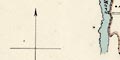
Each map has a north point; N-S line, E-W cross line, North marked by an arrow head. Cumberland's arrow is grander, and its S end has arrow flights. The maps are printed with North at the top of the sheet. |
|
|
|
||
|
scale line
scale |
Each map has a:-
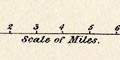
Scale of Miles Westmorland; chequered in miles, labelled at 5 miles. The. The 8 miles = 49.6 mm gives a scale 1 to 259572. The map scale is about:- 1 to 260000 4 miles to 1 inch Cumberland; marked and labelled at miles. The 10 miles = 37.96 mm gives a scale 1 to 424629. The map scale is about:- 1 to 420000 6.5 miles to 1 inch |
|
|
|
||
| coast line |
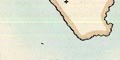
The oast line on the Cumberland map is emphasised by a blue tint in the offing. |
|
|
|
||
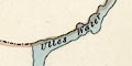
| rivers |
Rivers are not shown except where they are a boundary feature. For example the River Duddon on the Cumberland map; the Rivers Eamont and Eden on the Westmorland Map (but not on the Cumberland map), but not the Winster, ... |
|
|
|
||
| lakes |
Lakes are ignored except where they are a boundary
feature. For example: Ullswater and Windermere on the
Westmorland map, and one bank of Ullswater on the Cumberland
map. On the Westmorland map you have to know that part of
the lake is not shown, that the boundary is through the
middle of the lake.
Notice that the county boundaries do not match exactly. Although not a boundary, Derwent Water is shown in outline with islands, on the Cumberland map. |
|
|
|
||
|
county
table of data electoral data |
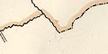
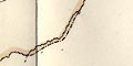
County boundaries are a dot dash line, except where a river or other feature is the boundary. 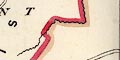
Cumberland is divided into two proposed electoral Divisions, the boundary a bold red line following ward boundaries. The divisions are labelled:- EASTERN DIVISION WESTERN DIVISION Westmorland has some statistical data, printed below the title upper left:- Population in 1831 ... 55,000 Assessed Taxes ... ~9,773 |
|
|
|
||
| wards |
Ward, comparable to hundred, boundaries are a fine dotted
line, tinted brown. The ward areas are labelled.
Westmorland:-
EAST WARD WEST WARD KENDAL WARD LONSDALE WARD Cumberland (notice the brown tint is missed along part of the county division boundary), Eastern Division:- ESKDALE WARD LEATH WARD CUMBERLAND WARD Cumberland, Western Division:- ALLERDALE WARD BELOW DERWENT ALLERDALE WARD ABOVE DERWENT |
|
|
|
||
| settlements |
Settlements with an electoral significance are marked by
symbols formally declared in the table of symbols. A few
other places are marked by blocks or a cross, to provide
some orientation for the map reader. Places are
differentiated by style of labelling, but based on electoral
status rather than importance. Remember that all the
electoral data is proposed, not definite.
|
|
|
|
||
| Westmorland | ||
| Kendal |
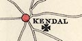
Borough sends 1 member, Polling Place |
|
| Appleby |

Principal Place of Election, Polling Place |
|
| Kirkby Stephen |
Polling Place
|
|
| Kirkby Lonsdale |
Polling Place
|
|
| Ambleside |
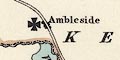
Polling Place |
|
| Shap |
Polling Place
|
|
|
|
||
| Cumberland, Western Division | ||
| Cockermouth |
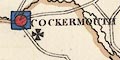
Principal Place of Election, Borough sends 1 Member, Polling Place |
|
| Whitehaven |
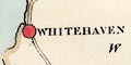
Borough sends 1 Member, Polling Place |
|
| Keswick |
Polling Place
|
|
| Bootle |
Polling Place
|
|
| Egremont |
Polling Place
|
|
|
|
||
| Cumberland, Eastern Division | ||
| Carlisle |
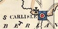
Principal Place of Election, Borough sends 2 Members, Polling Place |
|
| Brampton |
Polling Place
|
|
| Aldstone |
Polling Place
|
|
| Penrith |
Polling Place
|
|
| Wigton |
Polling Place
|
|
|
|
||
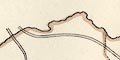
| roads |
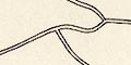
A limited netword of roads is drawn to connect places, drawn by double line. |
|
| Lewis's Atlas | ||
|
After the Reform Act 1832, a series of political maps was
published in an atlas of county and town maps; A
Topographical Dictionary of England. These are much the same
maps.
|
||
|
|
||
| Westmorland |
Political map, Westmorland, scale about 6 miles to 1
inch, drawn by R Creighton, engraved by J and C Walker,
published as plate 98 in A Topographical Dictionary of
England, 3rd edition vol.5, by S Lewis and Co, 87 Aldersgate
Street, London, 1835.
HMCMS:FA2000.30.98 |
|
|
|
||
| Kirby Kendal |
Political map, Kirby Kendal, Westmorland, scale about 0.5
miles to 1 inch, drawn by R Creighton, engraved by J and C
Walker, published as plate 99 in A Topographical Dictionary
of England, 3rd edition vol.5, by S Lewis and Co, 87
Aldersgate Street, London, 1835.
HMCMS:FA2000.30.99 |
|
|
|
||
| Cumberland |
Political map, Cumberland, scale about 7 miles to 1 inch,
drawn by R Creighton, engraved by J and C Walker, published
as plate 15 in A Topographical Dictionary of England, 3rd
edition vol.5, by S Lewis and Co, 87 Aldersgate Street,
London, 1835.
HMCMS:FA2000.30.15 |
|
|
|
||
|
Carlisle
White Haven Cockermouth |
Political map, Carlisle, White Haven, and Cockermouth,
Cumberland, various scales about 1-2 ins to 1 mile, drawn by
R Creighton, engraved by J and C Walker, published as plate
16 in A Topographical Dictionary of England, 3rd edition
vol.5 , by S Lewis and Co, 87 Aldersgate Street, London,
1835.
HMCMS:FA2000.30.16 |
|
|
And also relevant to Cumbria:-
|
||
|
|
||
| Lancashire |
Political map, Lancashire, scale about 8.5 miles to 1
inch, drawn by R Creighton, engraved by J and C Walker,
published as plate 43 in A Topographical Dictionary of
England, 3rd edition vol.5, by S Lewis and Co, 87 Aldersgate
Street, London, 1835.
HMCMS:FA2000.30.43 |
|
|
|
||
|
Lancaster
Blackburn Great and Little Bolton Wigan |
Political map, Lancaster, Blackburn, Great and Little
Bolton, and Wigan, Lancashire, various scales about 1.25 ins
to 1 mile, drawn by R Creighton, engraved by J and C Walker,
published as plate 44 in A Topographical Dictionary of
England, 3rd edition vol.5, by S Lewis and Co, 87 Aldersgate
Street, London, 1835.
HMCMS:FA2000.30.44 |
|
Lakes Guides menu.