 Old Cumbria Gazetteer
 |
 |
|
| roman fort, Brougham | ||
| Brocavum | ||
| locality:- | Brougham Castle | |
| civil parish:- | Brougham (formerly Westmorland) | |
| county:- | Cumbria | |
| locality type:- | roman fort | |
| coordinates:- | NY53832889 (etc) | |
| 1Km square:- | NY5328 | |
| 10Km square:- | NY52 | |
|
|
||
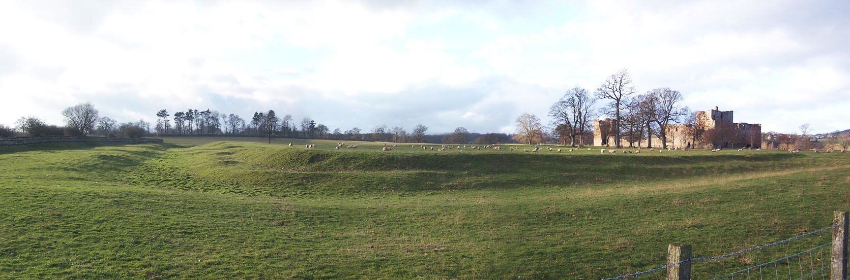 Click to enlarge BLM15.jpg From the cross roads. (taken 23.12.2005) |
||
|
|
||
| evidence:- | old map:- OS County Series (Wmd 4 9) placename:- Brovacum |
|
| source data:- | Maps, County Series maps of Great Britain, scales 6 and 25
inches to 1 mile, published by the Ordnance Survey, Southampton,
Hampshire, from about 1863 to 1948. |
|
|
|
||
| evidence:- | old map:- Speed 1611 (Wmd) placename:- Brocovum |
|
| source data:- | Map, hand coloured engraving, The Countie Westmorland and
Kendale the Cheif Towne, scale about 2.5 miles to 1 inch, by
John Speed, 1610, published by George Humble, Popes Head Alley,
London, 1611-12.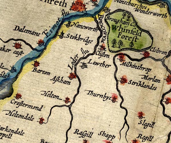 SP14NY52.jpg "BROCOVUM" no symbol item:- Armitt Library : 2008.14.5 Image © see bottom of page |
|
|
|
||
| evidence:- | old map:- Morden 1695 (Wmd) placename:- Bravoniacum |
|
| source data:- | Map, hand coloured engraving, Westmorland, scale about 2.5 miles to 1 inch, by Robert
Morden, published by Abel Swale, the Unicorn, St Paul's Churchyard, Awnsham, and John
Churchill, the Black Swan, Paternoster Row, London, 1695.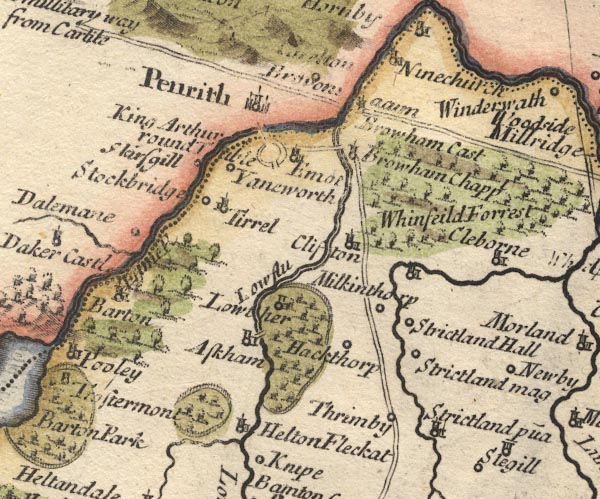 MD10NY52.jpg "Bravon[i]acum" item:- JandMN : 24 Image © see bottom of page |
|
|
|
||
| evidence:- | old map:- Stukeley 1723 placename:- Overborough placename:- Galava |
|
| source data:- | Road map, uncoloured engraving, the Antonine Itineraries through
Britain, scale about 55 miles to 1 inch, plotted by William
Stukeley, 1723, published London, 1724.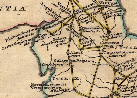 click to enlarge click to enlargeStu1Cm.jpg "Galava / Overborough" item:- Hampshire Museums : FA2001.171 Image © see bottom of page |
|
|
|
||
| evidence:- | perhaps descriptive text:- Defoe 1724-26 placename:- Brovoniacum |
|
| source data:- | Tour through England and Wales, by Daniel Defoe, published in
parts, London, 1724-26. "The Roman highway, ... passing the Eden a little north from Perith, at an antient Roman station call'd Brovoniacum," |
|
|
|
||
| evidence:- | old map:- Jefferys 1770 (Wmd) placename:- Brovoniacum |
|
| source data:- | Map, 4 sheets, The County of Westmoreland, scale 1 inch to 1
mile, surveyed 1768, and engraved and published by Thomas
Jefferys, London, 1770.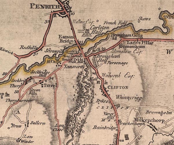 J5NY52NW.jpg "Brovoniacum" antiquity item:- National Library of Scotland : EME.s.47 Image © National Library of Scotland |
|
|
|
||
| evidence:- | old text:- Pennant 1773 placename:- Brovocum placename:- Broconiacum |
|
| source data:- | Book, A Tour from Downing to Alston Moor, 1773, by Thomas
Pennant, published by Edward Harding, 98 Pall Mall, London, 1801. goto source goto sourcePennant's Tour 1773, page 155 "[Brougham Castle] ... On its site, or perhaps near to it, had been the Roman station Brovocum, or Broconiacum. ..." |
|
|
|
||
| evidence:- | old map:- Donald 1774 (Cmd) placename:- Brovoniacum |
|
| source data:- | Map, hand coloured engraving, 3x2 sheets, The County of Cumberland, scale about 1
inch to 1 mile, by Thomas Donald, engraved and published by Joseph Hodskinson, 29
Arundel Street, Strand, London, 1774.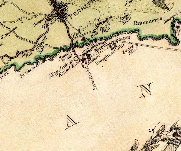 D4NY52NW.jpg "Brovoniacum" square within a square; roman fort, drawn boldly item:- Carlisle Library : Map 2 Image © Carlisle Library |
|
|
|
||
| evidence:- | old map:- Pennant 1777 placename:- Brovacum |
|
| source data:- | Map, hand coloured engraving, A Map of Scotland, Hebrides and
Part of England, drawn for Thomas Pennant, engraved by J Bayly,
published by Benjamin White, London, 1777. click to enlarge click to enlargePEN1Cm.jpg "BROVACUM / Brougham" circle; buildings, village, etc item:- private collection : 66 Image © see bottom of page |
|
|
|
||
| evidence:- | old text:- Camden 1789 (Gough Additions) placename:- Brocavum item:- roman altar; altar, roman; roman inscription; inscription, roman |
|
| source data:- | Book, Britannia, or A Chorographical Description of the Flourishing Kingdoms of England,
Scotland, and Ireland, by William Camden, 1586, translated from the 1607 Latin edition
by Richard Gough, published London, 1789. goto source Page 160:- "..." "It is agreed the BROUGHAM is the BROCAVUM of Antoninus' 5th Iter, not Brovoniacum, for there is no such name, but not the BRABONIACUM of the Notitia, which Gruter confounds with Brocavicum its Borcovicum. Antoninus's BROVONACAE, which Gale places at Kendal, and makes the same with Brocavum, is by Ward removed to Kirby Thor, or Whelp castle. Stukeley makes it Galava. Brougham castle stands within the station, and there is a fragment of an altar inscribed, PRO SE ET SVIS. L. L. M. remarkable only for the form of the stops. He says the Roman city lies on the east side of the Louther just by the castle, and is very easily traced. He saw many fragments of altars and inscriptions at the hall; and in the wall by the Roman road beyond the castle and near the countess of Pembroke's pillar a pretty busto part of a funeral monument, and further on another bas relievo much defaced. He imagined the high ground by this pillar, where most of the inscriptions were found, was the site of the city, rather perhaps of the pomaerium, or cemetery." "Horsley gives Mr. Camden's inscription here thus:" ".IMP. .C. VAL CONST ANTINO PIENT AVG:" "and refers it to Constantine the Great, but of a later date than that in his honor found in the wall. He doubts if it be the same which Mr. Camden saw. It is now at Appleby. Under it had been another inserted in the wall, whence the inscriptions at Appleby were taken, though now they are lying loose on the ground. The inscription on this other stone is modern, and perhaps by Mr. Bainbrigg:" "H. L. INVENT. E BROVONACI." "i.e. Hic lapsis inventus est Brovonaci." "To this same station must be referred another inscription whose original Mr. Horsley would gladly have recovered, but was told two or three inscribed stones had lately been destroyed by masons at Appleby, and this might be one. Burton and Gale give it" "DEABVS MATRIBVS TRAMAI. VEX. GERMA. P. V. R. D. PRO SALVTE RFVS. L. M." "which is to be read:" "Deabus Matribus tramarinis vexillato Germa-" goto sourcePage 161:- "norum quo salute republicae volum solvit libens merito." "norum quo salute republicae volum solvit libens merito." "..." |
|
|
|
||
| evidence:- | old text:- Camden 1789 placename:- Brovoniacum placename:- Brocovum placename:- Broconiacum item:- Antonine Itineraries; Notitia Dignitatum |
|
| source data:- | Book, Britannia, or A Chorographical Description of the Flourishing Kingdoms of England,
Scotland, and Ireland, by William Camden, 1586, translated from the 1607 Latin edition
by Richard Gough, published London, 1789. goto source Page 148:- "... BROVONIACUM, 20 Italian and 17 English miles from VERTERAE, as placed by Antoninus, who called it likewise Brocovum, as does the Notitia Broconiacum, adding that the Numerus Defensorum was stationed here. Though time has destroyed its buildings and glory, the name remains almost unaltered. For we still call it Brougham." |
|
|
|
||
| evidence:- | descriptive text:- Ford 1839 (3rd edn 1843) placename:- Brovoniacum |
|
| source data:- | Guide book, A Description of Scenery in the Lake District, by
Rev William Ford, published by Charles Thurnam, Carlisle, by W
Edwards, 12 Ave Maria Lane, Charles Tilt, Fleet Street, William
Smith, 113 Fleet Street, London, by Currie and Bowman,
Newcastle, by Bancks and Co, Manchester, by Oliver and Boyd,
Edinburgh, and by Sinclair, Dumfries, 1839. goto source Page 134:- "..." "BROUGHAM CASTLE," "On the site of the Roman Brovoniacum, at the confluence of the Eamont and Lowther, where many Roman remains have been found. ..." |
|
|
|
||
| evidence:- | old text:- Gents Mag item:- inscription, roman; roman inscription |
|
| source data:- | Magazine, The Gentleman's Magazine or Monthly Intelligencer or
Historical Chronicle, published by Edward Cave under the
pseudonym Sylvanus Urban, and by other publishers, London,
monthly from 1731 to 1922. goto source Gentleman's Magazine 1848 part 1 p.373 "... Dr. Markham, in the MS. before quoted, A.D. 1680, thus writes:- "That Browham was a Roman station is evident from the many Roman altars which have been frequently dug up here. In the year 1602 one was discovered near the confluence of the rivers Lowther and Eamont, with these letters inscribed,-" "IMP C. VAL CONSTAN TINO PIENT AUG" "and of late years several of the like kind have been found in the fields, but so shattered and defaced by the rashness and negligence of the workmen and labourers, that the characters are not legible." These are now, as before stated, in the great court near the entrance gate tower [Brougham Hall], in a quiet snug corner, not exposed to any danger. Gale, in his edition of the Itinerary of Antoninus, ed. 1719, p.97,- the latter part of the fifth journey from London to Carlisle,- gives "Brovaco," Brougham, the intermediate station between Brough and Carlisle. Camden and Stukeley also mention the station. In Caxton's Chronicle, "The Description of Englande," &c. is the following passage:- "Other men wolde suppose yt Alcluid was that cite that now is called Burgham, in the north cou~tre of Westmorlonde, fast by Comberland, and standeth by the river Eden. The cite is there wondrously seen."" |
|
|
|
||
| evidence:- | old text:- Martineau 1855 placename:- Brovacum |
|
| source data:- | Guide book, A Complete Guide to the English Lakes, by Harriet
Martineau, published by John Garnett, Windermere, Westmorland,
and by Whittaker and Co, London, 1855; published 1855-76. goto source Page 171:- "... Brougham, Burg-ham (meaning Castle-town) was the Brovacum of the Romans, where, as we learn from Nicolson and Burn, they had a company of Defensores, and left many tokens of their presence in antiquities which have come to light from time to time. ..." |
|
|
|
||
| evidence:- | site plan:- Historical Monuments 1936 |
|
| source data:- | Site plan, uncoloured lithograph, Brougham Castle Roman and Mediaeval Earthworks,
Brougham, Westmorland, scale about 1 to 2500, published by Royal Commission on Historical
Monuments England, London, 1936.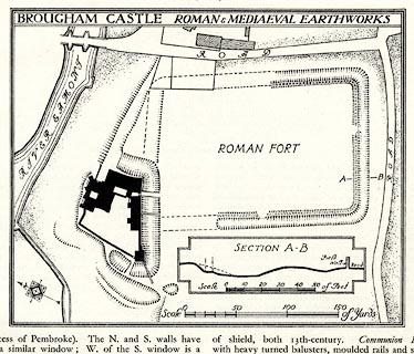 click to enlarge click to enlargeHMW039.jpg On p.55 of the Inventory of the Historical Monuments in Westmorland. printed, top "BROUGHAM CASTLE ROMAN AND MEDIAEVAL EARTHWORKS" RCHME no. Wmd, Brougham 1 item:- Armitt Library : A745.39 Image © see bottom of page |
|
|
|
||
| evidence:- | textbook:- Rivet and Smith 1979 placename:- Brocavum placename:- Brocavo |
|
| source data:- | ||
|
|
||
| evidence:- | old map:- Horsley 1732 placename:- Brocavum placename:- Brougham |
|
| source data:- | Map, uncoloured engraving, Britannia Antiqua, roman Britain,
scale about 50 miles to 1 inch, by John Horsley, perhaps 1732,
edition published about 1869?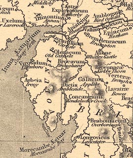 click to enlarge click to enlargeHOR1Cm.jpg "Brocavum / Brougham" item:- JandMN : 429 Image © see bottom of page |
|
|
|
||
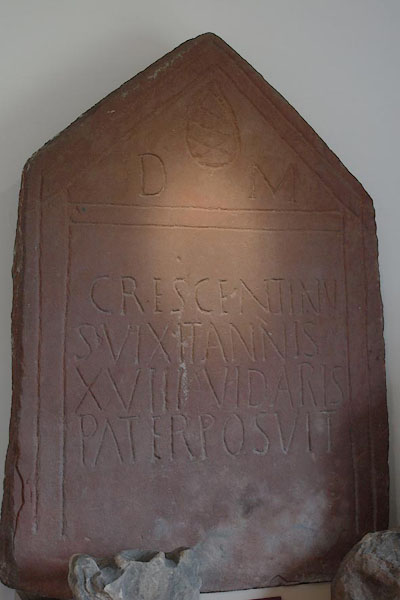 BTF54.jpg Roman inscription (at Brougham Castle). (taken 18.7.2010) 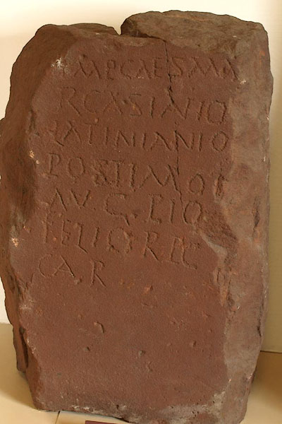 BTF55.jpg Roman inscription (at Brougham Castle). (taken 18.7.2010) |
||
|
|
||
Lakes Guides menu.