 Old Cumbria Gazetteer
 |
 |
|
| Mote, Brampton | ||
| Brampton Motte | ||
| locality:- | Brampton | |
| civil parish:- | Brampton (formerly Cumberland) | |
| county:- | Cumbria | |
| locality type:- | motte and bailey | |
| locality type:- | castle | |
| coordinates:- | NY53326128 (etc) | |
| 1Km square:- | NY5361 | |
| 10Km square:- | NY56 | |
|
|
||
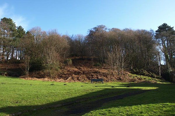 BUA94.jpg (taken 16.2.2011) |
||
|
|
||
| evidence:- | old map:- OS County Series (Cmd 18 5) placename:- Moat, The |
|
| source data:- | Maps, County Series maps of Great Britain, scales 6 and 25
inches to 1 mile, published by the Ordnance Survey, Southampton,
Hampshire, from about 1863 to 1948. |
|
|
|
||
| evidence:- | old map:- OS County Series (Cmd 18) placename:- Moat, The |
|
| source data:- | Maps, County Series maps of Great Britain, scales 6 and 25
inches to 1 mile, published by the Ordnance Survey, Southampton,
Hampshire, from about 1863 to 1948. "The Moat" |
|
|
|
||
| evidence:- | descriptive text:- Simpson 1746 placename:- Mote, The |
|
| source data:- | Atlas, three volumes of maps and descriptive text published as
'The Agreeable Historian, or the Compleat English Traveller
...', by Samuel Simpson, 1746. goto source goto source"..." "... By it [Brampton] there is a high Hill, called the Mote, ditched round at the Top, from which there is a clear Prospect over all the Country. Below this, ... have been found several Roman Inscriptions." |
|
|
|
||
| evidence:- | old text:- Pennant 1773 placename:- Moat, The placename:- Castle Hill |
|
| source data:- | Book, A Tour from Downing to Alston Moor, 1773, by Thomas
Pennant, published by Edward Harding, 98 Pall Mall, London, 1801. goto source Pennant's Tour 1773, page 172 "The Moat, or the Castle-hill, is a vast circular mount near the town: not far from the top is a trench and rampart; and on the last, in one part, is a ridge of raised earth, about fourteen feet long and four broad. As it lies so near to the wall, it was possibly exploratory, and the work of the Romans." |
|
|
|
||
| evidence:- | old map:- Donald 1774 (Cmd) |
|
| source data:- | Map, hand coloured engraving, 3x2 sheets, The County of Cumberland, scale about 1
inch to 1 mile, by Thomas Donald, engraved and published by Joseph Hodskinson, 29
Arundel Street, Strand, London, 1774.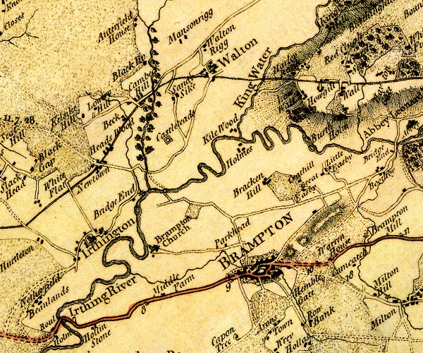 D4NY56SW.jpg hill hachuring; a hill or mountain item:- Carlisle Library : Map 2 Image © Carlisle Library |
|
|
|
||
| evidence:- | old text:- Camden 1789 placename:- Mote, The |
|
| source data:- | Book, Britannia, or A Chorographical Description of the Flourishing Kingdoms of England,
Scotland, and Ireland, by William Camden, 1586, translated from the 1607 Latin edition
by Richard Gough, published London, 1789. goto source Page 176:- "... Nor must I omit that at Brampton is a high hill fortified at the top with a ditch and called The Mote, commanding an extensive prospect over the country below." |
|
|
|
||
| evidence:- | old text:- Camden 1789 (Gough Additions) placename:- Moat, The |
|
| source data:- | Book, Britannia, or A Chorographical Description of the Flourishing Kingdoms of England,
Scotland, and Ireland, by William Camden, 1586, translated from the 1607 Latin edition
by Richard Gough, published London, 1789. goto source Page 201:- "..." "... Brampton ... Near the town is a large round hill called the moat, 50 yards high, gently and gradually tapering from the base to the summit with a trench or ditch round it at the top." "..." goto sourcePage 203:- "..." "... Brampton, ... The moat is a considerable fortification, probably Danish, near 360 feet perpendicular, about 40 feet perpendicular from the crown, a ditch near 20 feet deep and 300 paces in circumference, the top a level plain 40 paces diameter." |
|
|
|
||
| notes:- |
motte and ditch |
|
| Perriam, D R &Robinson, J: 1998: Medieval Fortified Buildings of Cumbria: CWAAS::
ISBN 1 873124 23 6; illustration |
||
|
|
||
Lakes Guides menu.