 Old Cumbria Gazetteer
 |
 |
|
| Morecambe Bay | ||
| site name:- | Irish Sea | |
| civil parish:- | Aldingham (formerly Lancashire) | |
| civil parish:- | Lower Allithwaite (formerly Lancashire) | |
| civil parish:- | Lower Holker (formerly Lancashire) | |
| county:- | Cumbria | |
| locality type:- | bay | |
| coordinates:- | SD37406840 (etc etc) | |
| 1Km square:- | SD3768 | |
| 10Km square:- | SD36 | |
| county:- | Lancashire | |
| locality type:- | bay | |
|
|
||
| evidence:- | old map:- OS County Series (Wmd 42 15) placename:- Morecambe Bay |
|
| source data:- | Maps, County Series maps of Great Britain, scales 6 and 25
inches to 1 mile, published by the Ordnance Survey, Southampton,
Hampshire, from about 1863 to 1948. "MORECAMBE BAY / High Water Mark of Ordinary Spring Tides" |
|
| source data:- | Maps, County Series maps of Great Britain, scales 6 and 25
inches to 1 mile, published by the Ordnance Survey, Southampton,
Hampshire, from about 1863 to 1948. "MORE[ ] / High Water Mark of Ordinary Spring Tides" shows the coastline to be as far west as Saltcote Wood |
|
| source data:- | Maps, County Series maps of Great Britain, scales 6 and 25
inches to 1 mile, published by the Ordnance Survey, Southampton,
Hampshire, from about 1863 to 1948. "[ ] CAMBE BAY / Line of Ordinary High Tides" |
|
|
|
||
| evidence:- | probably old map:- Lloyd 1573 |
|
| source data:- | Map, hand coloured copper plate engraving, Angliae Regni,
Kingdom of England, with Wales, scale about 24 miles to 1 inch, authored by Humphrey
Lloyd, Denbigh, Clwyd, drawn and engraved
by Abraham Ortelius, Netherlands, 1573. click to enlarge click to enlargeLld1Cm.jpg item:- Hampshire Museums : FA1998.69 Image © see bottom of page |
|
|
|
||
| evidence:- | old map:- Speed 1611 (Cum/EW) |
|
| source data:- | Map, hand coloured engraving, Kingdome of Great Britaine and
Ireland, scale about 36 miles to 1 inch, by John Speed, about
1610-11, published by Thomas Bassett, Fleet Street and Richard
Chiswell, St Paul's Churchyard, London, 1676? click to enlarge click to enlargeSPD6Cm.jpg bay item:- private collection : 85 Image © see bottom of page |
|
|
|
||
| evidence:- | old map:- Ogilby 1675 (plate 38) |
|
| source data:- | Road strip map, hand coloured engraving, continuation of the
Road from London to Carlisle, scale about 1 inch to 1 mile, by
John Ogilby, London, 1675.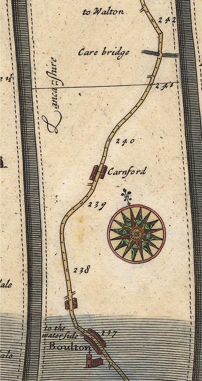 OG38m237.jpg In mile 237, Lancashire. Turning left off the road:- "to the water side" item:- JandMN : 21 Image © see bottom of page |
|
|
|
||
| evidence:- | old map:- Sanson 1679 |
|
| source data:- | Map, hand coloured engraving, Ancien Royaume de Northumberland
aujourdhuy Provinces de Nort, ie the Ancient Kingdom of
Northumberland or the Northern Provinces, scale about 9.5 miles
to 1 inch, by Nicholas Sanson, Paris, France, 1679. click to enlarge click to enlargeSAN2Cm.jpg bay item:- Dove Cottage : 2007.38.15 Image © see bottom of page |
|
|
|
||
| evidence:- | old map:- Morden 1695 (EW) |
|
| source data:- | Map, hand coloured engraving, England, including Wales, scale
about 27 miles to 1 inch, by Robert Morden, published by Abel
Swale Awnsham and John Churchil, London, about 1695. click to enlarge click to enlargeMRD3Cm.jpg bay item:- JandMN : 339 Image © see bottom of page |
|
|
|
||
| evidence:- | old map:- Stukeley 1723 |
|
| source data:- | Road map, uncoloured engraving, the Antonine Itineraries through
Britain, scale about 55 miles to 1 inch, plotted by William
Stukeley, 1723, published London, 1724.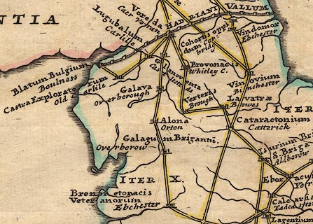 click to enlarge click to enlargeStu1Cm.jpg item:- Hampshire Museums : FA2001.171 Image © see bottom of page |
|
|
|
||
| evidence:- | old text:- Mackenzie 1776 placename:- |
|
| source data:- | Charts, and sailing directions, Nautical Descriptions of the
West Coast of Great Britain, Bristol Channel to Cape Wrath, by
Murdoch Mackenzie, published London, 1776. goto source goto sourcePage 18:- "... ..." "KENT River." "The River Kent, between Sunderland and the Piel-of-Foudray, is very dangerous, and not to be attempted by any stranger, except in necessity; as there are neither buoys, perches, or distinct land-marks to point out the channels to one that is not particularly acquainted. When a vessel is forced into this Bay, the only channels to be pursued are, either Furness, or Grange; the former on the west side of Cartmel-wharfs Bank, which dries about low-water only, the other on the E. side of it: at four hours of flood, a vessel, that draws ten or twelve feet, will have sufficient water over Cartmel-wharfs, near the channel. These channels often discover themselves, by the appearance of the water in them; a good look-out is therefore necessary here." |
|
|
|
||
| evidence:- | old map:- Pennant 1777 placename:- Moricambe Aestuarium |
|
| source data:- | Map, hand coloured engraving, A Map of Scotland, Hebrides and
Part of England, drawn for Thomas Pennant, engraved by J Bayly,
published by Benjamin White, London, 1777. click to enlarge click to enlargePEN1Cm.jpg "MORICAMBE AEST" bay, and sands item:- private collection : 66 Image © see bottom of page |
|
|
|
||
| evidence:- | old text:- Camden 1789 (Gough Additions) placename:- Cartmel Bay placename:- Moricambe |
|
| source data:- | Book, Britannia, or A Chorographical Description of the Flourishing Kingdoms of England,
Scotland, and Ireland, by William Camden, 1586, translated from the 1607 Latin edition
by Richard Gough, published London, 1789. goto source Page 142:- "... Ptolemy's MORICAMBE (sic) is Cartmel bay, perhaps from British Moreb, a haven and Cain white or beautiful, from the white rocks on this coast." "..." goto sourcePage 153:- "... Helslack tower, now in ruins. ... Arnside tower, the walls thereof not yet much decayed. These towers seem to have been erected to guard the bay; as there are on the opposite side the vestiges of Broughton tower and Bazin tower, so there is Castle head upon the island in Lindal Pow, and higher up the moses of Methop, Ulva, and Foulsham were inaccessible. In the centre of the bay is Peel castle." |
|
|
|
||
| evidence:- | old map:- Ptolemy 1793 placename:- Moricambe AEstuarium |
|
| source data:- | Map, hand coloured engraving, Albion et Hibernia Britannicae
Insulae, from the data of Claudius Ptolemy, 2nd century, on the
example of Gerard Mercator, 16th century, scale about 55 miles
to 1 inch, engraved by Basire, published for the Society of
Antiquaries, 1793.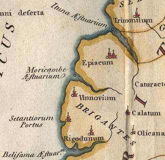 click to enlarge click to enlargePTY3Cm.jpg "Moricambe AEstuarium" item:- Hampshire Museums : FA2002.651 Image © see bottom of page |
|
|
|
||
| evidence:- | old map:- Horsley 1732 placename:- Morecambe AEstuar placename:- Morecambe Bay |
|
| source data:- | Map, uncoloured engraving, Britannia Antiqua, roman Britain,
scale about 50 miles to 1 inch, by John Horsley, perhaps 1732,
edition published about 1869?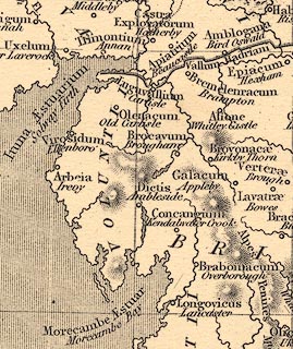 click to enlarge click to enlargeHOR1Cm.jpg "Morecambe AEstuar / Morecambe Bay" item:- JandMN : 429 Image © see bottom of page |
|
|
|
||
| evidence:- | old map:- Ptolemy 1578 |
|
| source data:- | Map, hand coloured engraving, Prima Europe tabula, Europe Map 1,
Ptolemy map of roman Britain, by Gerard Mercator, 1578.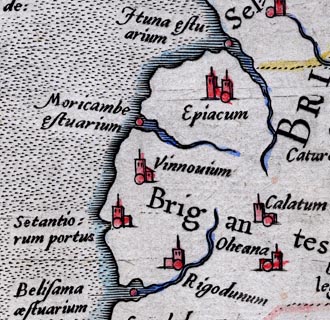 click to enlarge click to enlargePty1Cm.jpg item:- private collection : 13 Image © see bottom of page |
|
|
|
||
| evidence:- | old map:- Cooke 1802 placename:- Bay of Morecambe |
|
| source data:- | Map, Lancashire, scale about 18 miles to 1 inch, by George
Cooke, 1802, bound in Gray's New Book of Roads, 1824, published
by Sherwood, Jones and Co, Paternoster Road, London, 1824. click to enlarge click to enlargeGRA1La.jpg "BAY OF MORECAMBE" bay item:- Hampshire Museums : FA2000.62.6 Image © see bottom of page |
|
|
|
||
| evidence:- | old map:- Perrot 1823 placename:- Baie de Morecambe |
|
| source data:- | Map, hand coloured engraving, Cumberland and Westmoreland ie
Westmorland, scale about 38 miles to 1 inch, by Aristide Michel
Perrot, engraved by Migneret, 1823, published by Etienne Ledoux,
9 Rue Guenegaud, Paris, France, 1824-48. click to enlarge click to enlargePER2.jpg "B. de Morecambe" bay item:- Dove Cottage : 2007.38.45 Image © see bottom of page |
|
|
|
||
| evidence:- | descriptive text:- Ford 1839 (3rd edn 1843) placename:- Bay of Morecambe |
|
| source data:- | Guide book, A Description of Scenery in the Lake District, by
Rev William Ford, published by Charles Thurnam, Carlisle, by W
Edwards, 12 Ave Maria Lane, Charles Tilt, Fleet Street, William
Smith, 113 Fleet Street, London, by Currie and Bowman,
Newcastle, by Bancks and Co, Manchester, by Oliver and Boyd,
Edinburgh, and by Sinclair, Dumfries, 1839. goto source Page 152:- "..." "... The ruins of Hilslack and Arnside towers are not very distant; they seem to have been erected to guard the Bay of Morecambe. ..." |
|
|
|
||
| evidence:- | old map:- Ford 1839 map placename:- Morecambe Bay |
|
| source data:- | Map, uncoloured engraving, Map of the Lake District of
Cumberland, Westmoreland and Lancashire, scale about 3.5 miles
to 1 inch, published by Charles Thurnam, Carlisle, and by R
Groombridge, 5 Paternoster Row, London, 3rd edn 1843. FD02SD26.jpg 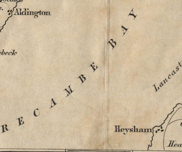 FD02SD36.jpg 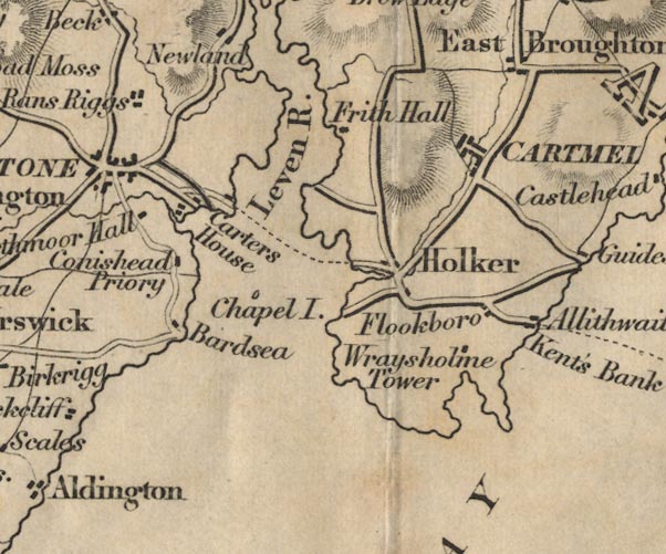 FD02SD37.jpg 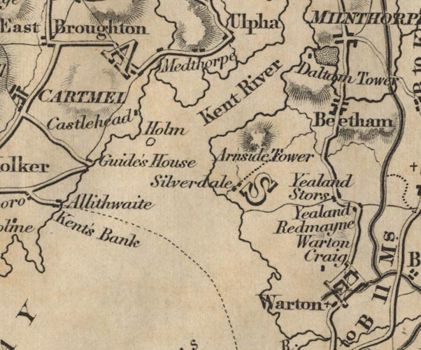 FD02SD47.jpg "MORECAMBE BAY" item:- JandMN : 100.1 Image © see bottom of page |
|
|
|
||
| evidence:- | old map:- Ford 1839 map placename:- Morecambe Bay |
|
| source data:- | Map, uncoloured engraving, Map of the Lake District of
Cumberland, Westmoreland and Lancashire, scale about 3.5 miles
to 1 inch, published by Charles Thurnam, Carlisle, and by R
Groombridge, 5 Paternoster Row, London, 3rd edn 1843. FD02SD26.jpg FD02SD36.jpg FD02SD37.jpg FD02SD47.jpg "MORECAMBE BAY" item:- JandMN : 100.1 Image © see bottom of page |
|
|
|
||
| evidence:- | old map:- Garnett 1850s-60s H placename:- Morecambe Bay |
|
| source data:- | Map of the English Lakes, in Cumberland, Westmorland and
Lancashire, scale about 3.5 miles to 1 inch, published by John
Garnett, Windermere, Westmorland, 1850s-60s.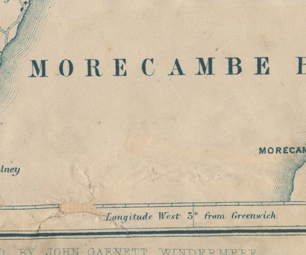 GAR2SD36.jpg "MORECAMBE BAY" area  GAR2SD46.jpg "MORECAMBE BAY" item:- JandMN : 82.1 Image © see bottom of page |
|
|
|
||
| evidence:- | old text:- Gents Mag |
|
| source data:- | Magazine, The Gentleman's Magazine or Monthly Intelligencer or
Historical Chronicle, published by Edward Cave under the
pseudonym Sylvanus Urban, and by other publishers, London,
monthly from 1731 to 1922. goto source Gentleman's Magazine 1852 part 2 p.191 "The reclaiming of Morecambe Bay in Lancashire is at length about to be carried into effect. The right has been purchased from the Admiralty by Messrs. Brogden and Co. and the undertaking will be carried out conjointly with the formation of the Ulverstone and the Lancaster Railway (sic). The rivers Crake and Leven will be confined to a fixed channel, and the bay will no doubt be left in a great measure to silt up. This vast tract, which extends from Tridlea-point (near to the Ulversone Canal foot) to Greenodd, comprises an area of about 145,000 acres." |
|
|
|
||
| evidence:- | old print:- Barber 1873 |
|
| source data:- | Print, ?colour lithograph, Head of Morecambe Bay from Leven
Viaduct, published by The Graphotyping Co, 7 Garrick Street and
Simpkin, Marshall and Co, Stationers' Hall Court, London, and by
J Atkinson, King Street, Ulverston, Cumberland, about 1873.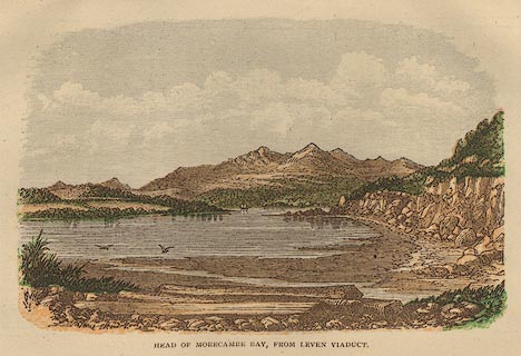 click to enlarge click to enlargeBB1E03.jpg "HEAD OF MORECAMBE BAY, FROM LEVEN VIADUCT" item:- JandMN : 69.4 Image © see bottom of page |
|
|
|
||
| evidence:- | text:- Rivet and Smith 1979 placename:- Moricambe placename:- Moriacambe |
|
| source data:- | Morecambe Bay (whose name is an antiquarian revival). |
|
|
|
||
| evidence:- | old print:- Bogg 1898 item:- cockles; cart; basket |
|
| source data:- | Print, engraving, Cockle Gatherers on Cartmel Sands, Morecambe Bay, by Gilbert Foster,
published by Edmund Bogg, 3 Woodhouse Lane, and James Miles, Guildford Street, Leeds,
Yorkshire, 1898.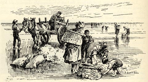 click to enlarge click to enlargeBGG186.jpg Included on p.220 of Lakeland and Ribblesdale, by Edmund Bogg. item:- JandMN : 231.86 Image © see bottom of page |
|
|
|
||
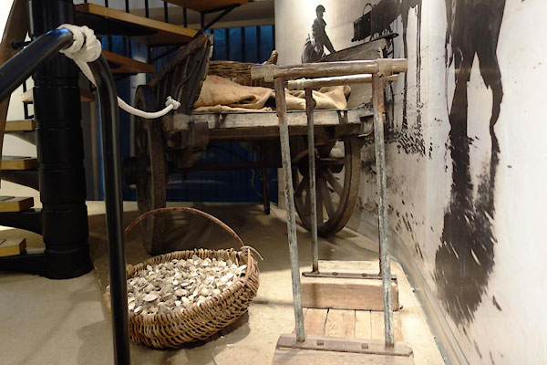 BZG15.jpg Cockling; cart, basket of cockles, etc (taken 6.9.2013) courtesy of Lancaster Museums. 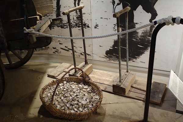 BZG16.jpg Cockling; cart, basket of cockles, jumbo, etc (taken 6.9.2013) courtesy of Lancaster Museums. |
||
| Cockles are scooped up from the sand by a fork with three bent iron times, a craam.
The jumbo is pounded on the and to make the cockles rise towards the surface. |
||
|
|
||
Lakes Guides menu.