 Old Cumbria Gazetteer
 |
 |
|
| Bew Castle, Bewcastle | ||
| Bew Castle | ||
| Bewcastle Castle | ||
| locality:- | Bewcastle | |
| civil parish:- | Bewcastle (formerly Cumberland) | |
| county:- | Cumbria | |
| locality type:- | castle | |
| coordinates:- | NY56567468 | |
| 1Km square:- | NY5674 | |
| 10Km square:- | NY57 | |
|
|
||
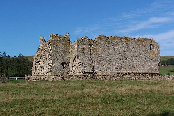 BMQ86.jpg From the churchyard. (taken 15.9.2006) 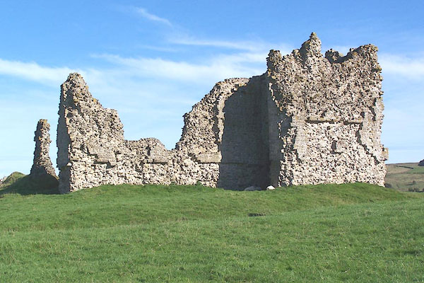 BMQ87.jpg (taken 15.9.2006) |
||
|
|
||
| evidence:- | old map:- OS County Series (Cmd 8 6) |
|
| source data:- | Maps, County Series maps of Great Britain, scales 6 and 25
inches to 1 mile, published by the Ordnance Survey, Southampton,
Hampshire, from about 1863 to 1948. "Castle (Remains of)" |
|
|
|
||
| evidence:- | old map:- Saxton 1579 placename:- Bewcastle |
|
| source data:- | Map, hand coloured engraving, Westmorlandiae et Cumberlandiae Comitatus ie Westmorland
and Cumberland, scale about 5 miles to 1 inch, by Christopher Saxton, London, engraved
by Augustinus Ryther, 1576, published 1579-1645.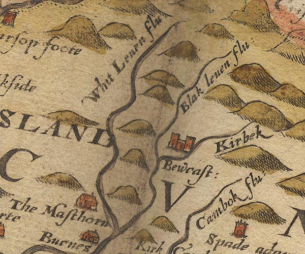 Sax9NY57.jpg Building with two towers, symbol for a castle. "Bewcast:" item:- private collection : 2 Image © see bottom of page |
|
|
|
||
| evidence:- | old map:- Burghley 1590 (facsimile) placename:- Bewcastell |
|
| source data:- | Facsimile map, A Platt of the Opposete Border of Scotland to ye West Marches of England,
parts of Cumberland and Scotland including the Debateable Land, from a manuscript
drawn for William Cecil, Lord Burghley, about 1590, published by R B Armstrong, 1897. courtesy of the National Library of Scotland 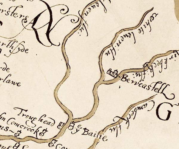 M048NY57.jpg "Bewcastell" circle, buildings or walls, tower item:- National Library of Scotland : MS6113 f.267 Image © National Library of Scotland |
|
|
|
||
| evidence:- | old map:- Speed 1611 (Cum/EW) placename:- Castle Bew |
|
| source data:- | Map, hand coloured engraving, Kingdome of Great Britaine and
Ireland, scale about 36 miles to 1 inch, by John Speed, about
1610-11, published by Thomas Bassett, Fleet Street and Richard
Chiswell, St Paul's Churchyard, London, 1676? click to enlarge click to enlargeSPD6Cm.jpg "Ca Bew" dot, circle, and tower item:- private collection : 85 Image © see bottom of page |
|
|
|
||
| evidence:- | old map:- Speed 1611 (Cmd) placename:- Bew Castle |
|
| source data:- | Map, hand coloured engraving, Cumberland and the Ancient Citie
Carlile Described, scale about 4 miles to 1 inch, by John Speed,
1610, published by J Sudbury and George Humble, Popes Head
Alley, London, 1611-12.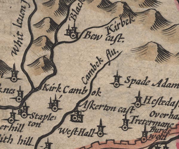 SP11NY57.jpg "Bew cast." circle, buildings, tower item:- private collection : 16 Image © see bottom of page |
|
|
|
||
| evidence:- | table of distances:- Simons 1635 placename:- Bewe Castle |
|
| source data:- | Table of distances, uncoloured engraving, Cumberland, with a
thumbnail map, scale about 41 miles to 1 inch, by Mathew Simons,
published in A Direction for the English Traviller, 1635.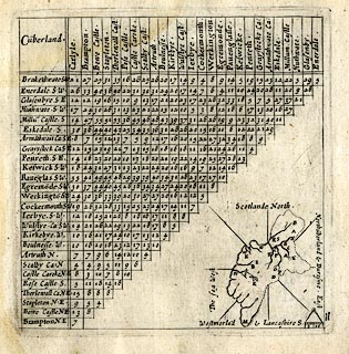 click to enlarge click to enlargeSIM4.jpg "Bewe Castle N.E." and tabulated distances; B on thumbnail map item:- private collection : 50.11 Image © see bottom of page |
|
|
|
||
| evidence:- | old map:- Jansson 1646 placename:- Bew Castle |
|
| source data:- | Map, hand coloured engraving, Cumbria and Westmoria, ie
Cumberland and Westmorland, scale about 3.5 miles to 1 inch, by
John Jansson, Amsterdam, Netherlands, 1646. JAN3NY57.jpg "Bew Cast" Buildings and tower with flag. item:- JandMN : 88 Image © see bottom of page |
|
|
|
||
| evidence:- | old map:- Sanson 1679 placename:- Bew |
|
| source data:- | Map, hand coloured engraving, Ancien Royaume de Northumberland
aujourdhuy Provinces de Nort, ie the Ancient Kingdom of
Northumberland or the Northern Provinces, scale about 9.5 miles
to 1 inch, by Nicholas Sanson, Paris, France, 1679. click to enlarge click to enlargeSAN2Cm.jpg "Bew" circle, two towers, flag; castle item:- Dove Cottage : 2007.38.15 Image © see bottom of page |
|
|
|
||
| evidence:- | old map:- Morden 1695 (Cmd) placename:- Bew Castle |
|
| source data:- | Map, uncoloured engraving, Cumberland, scale about 4 miles to 1
inch, by Robert Morden, 1695, published by Abel Swale, the
Unicorn, St Paul's Churchyard, Awnsham, and John Churchill, the
Black Swan, Paternoster Row, London, 1695-1715. MD12NY57.jpg "Bew Castle" Circle, building with two towers. item:- JandMN : 90 Image © see bottom of page |
|
|
|
||
| evidence:- | old map:- Bowen and Kitchin 1760 placename:- Beu Castle placename:- Bueth Castle |
|
| source data:- | Map, hand coloured engraving, A New Map of the Counties of
Cumberland and Westmoreland Divided into their Respective Wards,
scale about 4 miles to 1 inch, by Emanuel Bowen and Thomas
Kitchin et al, published by T Bowles, Robert Sayer, and John
Bowles, London, 1760.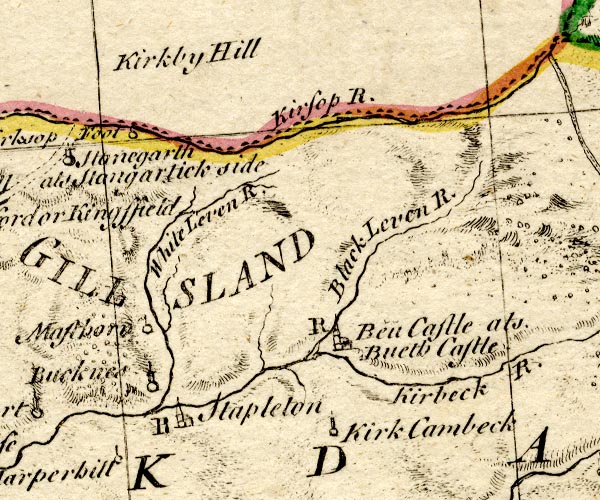 BO18NY57.jpg "Beu Castle als Bueth Castle / R" circle, building and tower, rectory item:- Armitt Library : 2008.14.10 Image © see bottom of page |
|
|
|
||
| evidence:- | old text:- Pennant 1773 placename:- Beucastle placename:- Bueth Castle |
|
| source data:- | Book, A Tour from Downing to Alston Moor, 1773, by Thomas
Pennant, published by Edward Harding, 98 Pall Mall, London, 1801. "About three mile farther is Beucastle, or Bueth Castle, so called from one Bueth, Lord of the country at the time of the Conquest, who is said to have repaired a Roman castle, and called it after his own name: ... Bueth's lands afterwards fell to the Crown. Henry II. bestowed it on the last Hubert de Vallibus; and by his"  goto source goto sourcePennant's Tour 1773, page 181 "daughter it came to Thomas de Multon. It passed through several hands till the fifth of Charles I. who, on consideration of two hundred pounds, granted it to Sir Richard Graham; and is now, with the vast territory round, the property of the Rev. Mr. Graham of Netherby." "The castle is small, square, and surrounded with a foss; was garrisoned in the year 1641, when it was dismantled, and the garrison removed to Carlisle." |
|
|
|
||
| evidence:- | old map:- Donald 1774 (Cmd) placename:- Bewcastle |
|
| source data:- | Map, hand coloured engraving, 3x2 sheets, The County of Cumberland, scale about 1
inch to 1 mile, by Thomas Donald, engraved and published by Joseph Hodskinson, 29
Arundel Street, Strand, London, 1774. D4NY57SE.jpg "Bewcastle" large building; a castle item:- Carlisle Library : Map 2 Image © Carlisle Library |
|
|
|
||
| evidence:- | old text:- Clarke 1787 placename:- Bewcastle |
|
| source data:- | Guide book, A Survey of the Lakes of Cumberland, Westmorland,
and Lancashire, written and published by James Clarke, Penrith,
Cumberland, and in London etc, 1787; published 1787-93. goto source Page 105:- "..." "I do not find any ancient authors mention a castle here [Castlerigg], Speed, who speaks of twenty-five in Cumberland, hath found out every one I ever heard or knew of, except Kirkoswald; how that has escaped him I cannot tell. I shall here put down their names, and, as well as I can, their most ancient owners, and supposed founders." "1. BEWCASTLE. Built by the Romans, and after the Conquest repaired by one Bueth, who gave it his own name, viz, Bueth-castle; he was killed by Robert the" goto sourcePage 106:- "Vallibus, who afterwards, to purchase absolution from the Pope, built Lanercost Priory, and endowed it." "..." |
|
|
|
||
| evidence:- | old text:- Camden 1789 placename:- Beucastle placename:- Bueth Castle |
|
| source data:- | Book, Britannia, or A Chorographical Description of the Flourishing Kingdoms of England,
Scotland, and Ireland, by William Camden, 1586, translated from the 1607 Latin edition
by Richard Gough, published London, 1789. goto source Page 176:- "..." "... The Leven and other river before-mentioned, rising in the very border of two kingdoms, passes by nothing remarkable except Beucastle, as it is commonly called, a royal castle in a waste tract with a garrison. In the public records it is written Bueth-castle, whence its name should seem to be derived from that Bueth, who about the time of Henry I. was a sort of absolute lord in these parts. Certain it is that in the reign of Edward III. it was the property of John baron de Strivelin, who married the daughter and coheiress of Adam de Swinborn." |
|
|
|
||
| evidence:- | old text:- Camden 1789 (Gough Additions) placename:- Bowecastle |
|
| source data:- | Book, Britannia, or A Chorographical Description of the Flourishing Kingdoms of England,
Scotland, and Ireland, by William Camden, 1586, translated from the 1607 Latin edition
by Richard Gough, published London, 1789. goto source Page 200:- "..." ""Bowecastle longing to the king, 10 mile east from Carluel on Kirkebek. Near about it be found Briton brikes with entayled work and portraitures in the old foundations."" "..." "The place has its name from Bueth its owner at the Conquest. The castle was demolished 1641." |
|
|
|
||
| evidence:- | site plan:- Curwen 1913 placename:- Bew Castle |
|
| source data:- | Site plan, lithograph, Bew Castle, Bewcastle, Cumberland, by T H B Grahams, published
for the Cumberland and Westmorland Antiquarian and Archaeological Society by Titus
Wilson, Kendal, Westmorland, 1913.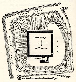 click to enlarge click to enlargeCW0125.jpg On p.138 of The Castles and Fortified Towers of Cumberland, Westmorland, and Lancashire North of the Sands, by John F Curwen. printed at bottom right:- "measured by / T. H. B.Grahams / 1910" item:- Armitt Library : A782.25 Image © see bottom of page |
|
|
|
||
| evidence:- | text:- Jackson 1990 placename:- Belcastell placename:- Boa Castle placename:- Bothe Castle placename:- Bowe Castle |
|
| source data:- | ||
|
|
||
| evidence:- | old painting:- placename:- Bew Castle |
|
| source data:- | Painting, watercolour, Bew Castle, Bewcastle, Cumberland, by William James Blacklock,
1840-58.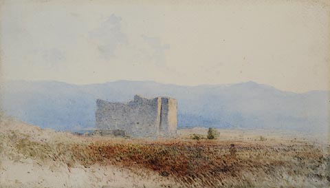 click to enlarge click to enlargePR0947.jpg A solitary figure on the right of the composition approaches a ruined castle standing in midst of heathery moorland with distant blue hills beyond. signed at bottom left:- "W J Blacklock" inscribed at top centre:- "Bew Castle Cumberland" item:- Tullie House Museum : 1946.67.15 Image © Tullie House Museum |
|
|
|
||
| evidence:- | old print:- Pennant 1773 (edn 1801) placename:- Beu Castle |
|
| source data:- | Print, engraving, Beu Castle, Bewcastle, Cumberland, drawn by Moses Griffith, engraved
by Comte, published by Edward Harding, 98 Pall Mall, London, 1801.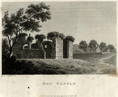 click to enlarge click to enlargePEN626.jpg Tipped in opposite p.180 of A Tour from Downing to Alston Moor, 1773, by Thomas Pennant. printed at bottom left, right, centre:- "Moses Griffith. Del / Comte Sc / BEU CASTLE / Pub June 1 1801 by Edw Harding 98 Pall Mall." item:- Armitt Library : A1057.26 Image © see bottom of page |
|
|
|
||
| evidence:- | possibly old painting:- placename:- Buit's Castle |
|
| source data:- | Painting, oil painting, Buit's Castle, Bewcastle, Cumberland, by William James Blacklock,
1844.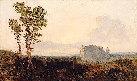 click to enlarge click to enlargePR0939.jpg To left of foreground cattle are grouped beside three spindly trees. A woman, her back to the viewer, carrying a basket balanced on her head, walks towards the ruins of a castle which are bathed in the rosy glow of a fading sunset. Distant hills lie beyond. labelled at reverse:- "Evening on the Gelt near Castle Carrock W J Blacklock 40 London St, Fitzroy Square No 3" item:- Tullie House Museum : 1946.67.4 Image © Tullie House Museum |
|
|
|
||
 BWQ25.jpg (taken 1.6.2012) 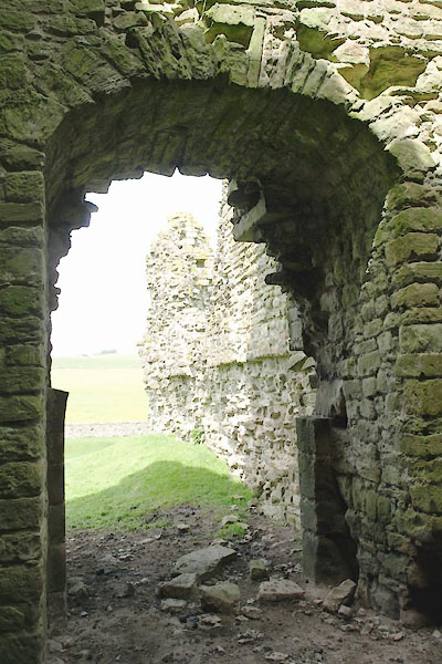 BWQ26.jpg (taken 1.6.2012) 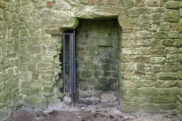 BWQ27.jpg (taken 1.6.2012) 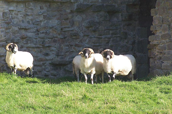 BMQ88.jpg Swaledale tups. (taken 15.9.2006) 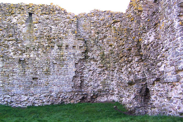 BMQ89.jpg (taken 15.9.2006) 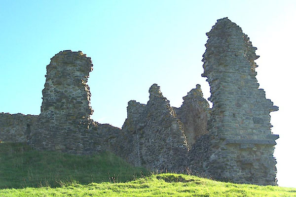 BMQ90.jpg (taken 15.9.2006) |
||
|
|
||
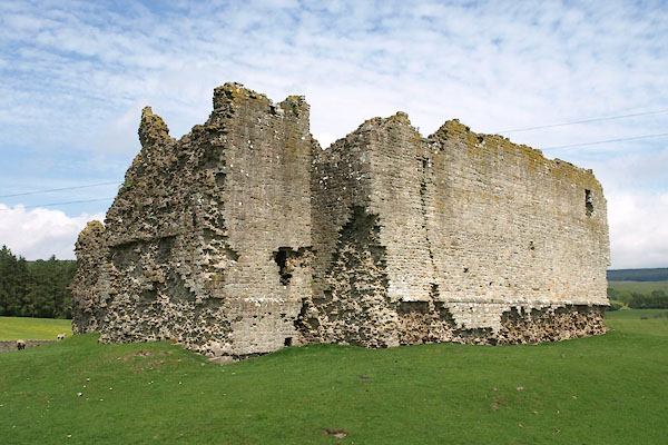
| hearsay:- |
Perhaps 13th century, 90 foot square enclosure, a tower and a gatehouse remain as
well as curtain wall. |
|
|
|
||
| notes:- |
Gateway, keep, moat, within the roman camp |
|
| Perriam, D R &Robinson, J: 1998: Medieval Fortified Buildings of Cumbria: CWAAS::
ISBN 1 873124 23 6; plan and illustrations |
||
|
|
||
Lakes Guides menu.