 Old Cumbria Gazetteer
 |
 |
|
|
| included in:- |
 M6 motorway M6 motorway |
||
| M6, Westmorland | |||
| Carnforth to Penrith | |||
| Penrith to Carnforth | |||
| locality:- | Carnforth | ||
| county:- | Lancashire | ||
| locality type:- | route | ||
| locality type:- | motorway | ||
| 10Km square:- | SD57 | ||
| civil parish:- | Burton-in-Kendal (formerly Westmorland) | ||
| civil parish:- | Holme (formerly Westmorland) | ||
| civil parish:- | Beetham (formerly Westmorland) | ||
| civil parish:- | Preston Patrick (formerly Westmorland) | ||
| civil parish:- | Old Hutton and Holmescales (formerly Westmorland) | ||
| civil parish:- | New Hutton (formerly Westmorland) | ||
| civil parish:- | Lambrigg (formerly Westmorland) | ||
| civil parish:- | Firbank (formerly Westmorland) | ||
| civil parish:- | Grayrigg (formerly Westmorland) | ||
| civil parish:- | Tebay (formerly Westmorland) | ||
| civil parish:- | Orton S (formerly Westmorland) | ||
| civil parish:- | Crosby Ravensworth (formerly Westmorland) | ||
| civil parish:- | Shap Rural (formerly Westmorland) | ||
| civil parish:- | Shap (formerly Westmorland) | ||
| civil parish:- | Thrimby (formerly Westmorland) | ||
| civil parish:- | Lowther (formerly Westmorland) | ||
| county:- | Cumbria | ||
| locality type:- | route | ||
| locality type:- | motorway | ||
| 10Km square:- | SD57 | ||
| 10Km square:- | SD58 | ||
| 10Km square:- | SD59 | ||
| 10Km square:- | SD69 | ||
| 10Km square:- | NY60 | ||
| 10Km square:- | NY50 | ||
| 10Km square:- | NY51 | ||
| 10Km square:- | NY52 | ||
|
|
|||
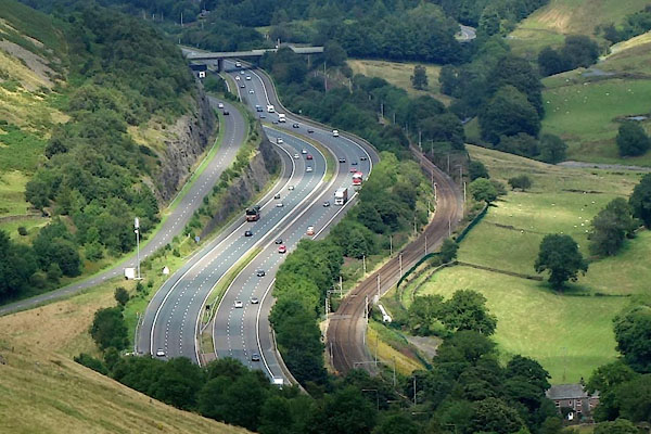 CGJ82.jpg (taken 10.8.2017) |
|||
|
|
|||
| notes:- |
Route |
||
| An early proposal for a north south motorway route in Westmorland was through the
Lune valley and Tebay. In 1959 there were objections condeming the route and the Ministry
of Transport asked for a review of options, and recommendations. Some of the routes
considered involved tunnels, which are not desirable for dangerous cargoes, and high
viaducts, for example: through Longsleddale, tunnel under Shap Fells, then the Hawes
Water valley etc; or along the line of the A6 with viaducts. Thirty variations were
brought forward in 1960. Stereophotography, origin and destination studies, and a
meteorological study, which argued against a route over Shap Fells, were included
in the report produced in 1962. The Killington and Lune Gorge route was commenced
October 1967, opened October 1970. The summit is 1036 feet, nearly 400 feet down from
the A6 Shap summit. |
|||
| References |
|||
| Yeadon, Harry L: 2005: Motoway Achievement & Building the Network, the North West
of England: Motorway Archive Trust &Phillimore and Co (Chichester, West Sussex)::
ISBN 1 86077 352 4 |
|||
|
|
|||
| places:- | [M6, junction 35] [M6, junction 36] M6, junction 37[M6, junction 38] M6, junction 39 M6, Hackthorpe |
||
|
|
|||
Lakes Guides menu.