 Old Cumbria Gazetteer
 |
 |
|
|
| road, through Grange-over-Sands | |||
| Grange-over-Sands road | |||
| Lindale to Flookburgh | |||
| Flookburgh to Lindale | |||
| B5277 | |||
| civil parish:- | Grange-over-Sands (formerly Lancashire) | ||
| civil parish:- | Lower Allithwaite (formerly Lancashire) | ||
| civil parish:- | Upper Allithwaite (formerly Lancashire) | ||
| civil parish:- | Lower Holker (formerly Lancashire) | ||
| county:- | Cumbria | ||
| locality type:- | route | ||
| 10Km square:- | SD48 | ||
| 10Km square:- | SD47 | ||
| 10Km square:- | SD37 | ||
|
|
|||
| evidence:- | old strip map:- CTC 1911 (Roads) |
||
| source data:- | Page 115 of Cyclists' Touring Club British Road Book new series vol.6, edited by F
B Sandford, published by Thomas Nelson and Sons, London etc, 1911.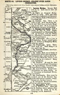 click to enlarge click to enlargeCTC2B5.jpg Strip road map, route 60, Levens Bridge Grange-over-Sands Broughton, scale roughly 5 miles to 1 inch. Together with an itinerary and gradient diagram. item:- JandMN : 491.115 Image © see bottom of page |
||
|
|
|||
| places:- |  Lindale, Upper Allithwaite Grange-over-Sands Allithwaite, Lower Allithwaite Flookburgh Lindale, Upper Allithwaite Grange-over-Sands Allithwaite, Lower Allithwaite Flookburgh |
||
|
|
|||
Lakes Guides menu.