 Old Cumbria Gazetteer
 |
 |
|
||
| road, Caldbeck to Aspatria | ||||
| Caldbeck to Aspatria | ||||
| Aspatria to Caldbeck | ||||
| A5299 | ||||
| civil parish:- | Caldbeck (formerly Cumberland) | |||
| civil parish:- | Boltons (formerly Cumberland) | |||
| civil parish:- | Allhallows (formerly Cumberland) | |||
| civil parish:- | Aspatria (formerly Cumberland) | |||
| county:- | Cumbria | |||
| locality type:- | route | |||
| 10Km square:- | NY33 | |||
| 10Km square:- | NY23 | |||
| 10Km square:- | NY24 | |||
| 10Km square:- | NY14 | |||
|
|
||||
| evidence:- | old strip map:- CTC 1911 (Roads) |
|||
| source data:- | Page 106 of Cyclists' Touring Club British Road Book new series vol.6, edited by F
B Sandford, published by Thomas Nelson and Sons, London etc, 1911.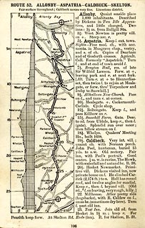 click to enlarge click to enlargeCTC2A6.jpg Strip road map, route 52, Allonby Aspatria Caldbeck Skelton, scale roughly 5 miles to 1 inch. Together with an itinerary and gradient diagram. item:- JandMN : 491.106 Image © see bottom of page |
|||
|
|
||||
| places:- |  Caldbeck Boltongate, Boltons Mealsgate, Boltons Aspatria Caldbeck Boltongate, Boltons Mealsgate, Boltons Aspatria |
|||
|
|
||||
| places:- |
|
|||
Lakes Guides menu.