Old Cumbria Gazetteer
 |
 |
|
||
| included in:- |
 road, Levens Bridge to Barrow-in-Furness road, Kendal to Kirkby Ireleth road, Levens Bridge to Barrow-in-Furness road, Kendal to Kirkby Ireleth |
|||
| road, Ulverston to Dalton-in-Furness | ||||
| Ulverston to Dalton-in-Furness | ||||
| Dalton-in-Furness to Ulverston | ||||
| A590 | ||||
| civil parish:- | Ulverston (formerly Lancashire) | |||
| civil parish:- | Pennington (formerly Lancashire) | |||
| civil parish:- | Lindal and Marton (formerly Lancashire) | |||
| civil parish:- | Dalton Town with Newton (formerly Lancashire) | |||
| county:- | Cumbria | |||
| locality type:- | road route | |||
| 10Km square:- | SD27 | |||
|
|
||||
| evidence:- | old map:- OS County Series (Lan 16) |
|||
| source data:- | Maps, County Series maps of Great Britain, scales 6 and 25
inches to 1 mile, published by the Ordnance Survey, Southampton,
Hampshire, from about 1863 to 1948. "KIRKBY KENDAL AND KIRKBY IRELETH TRUST" along road |
|||
|
|
||||
| evidence:- | road map:- Cary 1790 (Lan/edn 1792) |
|||
| source data:- | Road map, hand coloured engraving, Lancashire, scale about 18
miles to 1 inch, by John Cary, 181 Strand, London, 1790, edn
1792.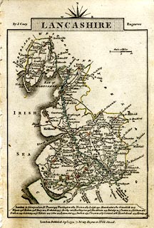 click to enlarge click to enlargeCY46.jpg double line item:- JandMN : 418 Image © see bottom of page |
|||
|
|
||||
| evidence:- | road book:- Cary 1798 (2nd edn 1802) |
|||
| source data:- | Road book, itineraries, Cary's New Itinerary, by John Cary, 181
Strand, London, 2nd edn 1802. goto source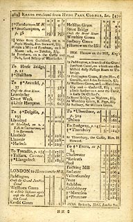 click to enlarge click to enlargeC38469.jpg page 468-470 part of item:- JandMN : 228.1 Image © see bottom of page |
|||
|
|
||||
| evidence:- | road book:- Cary 1798 (2nd edn 1802) |
|||
| source data:- | Road book, itineraries, Cary's New Itinerary, by John Cary, 181
Strand, London, 2nd edn 1802. goto source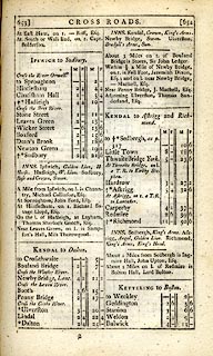 click to enlarge click to enlargeC38653.jpg page 653-654 "KENDAL to Dalton" part of item:- JandMN : 228.2 Image © see bottom of page |
|||
|
|
||||
| evidence:- | old map:- Cooke 1802 |
|||
| source data:- | Map, Lancashire, scale about 18 miles to 1 inch, by George
Cooke, 1802, bound in Gray's New Book of Roads, 1824, published
by Sherwood, Jones and Co, Paternoster Road, London, 1824.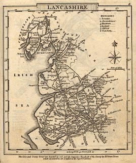 click to enlarge click to enlargeGRA1La.jpg double line, light dark solid; road item:- Hampshire Museums : FA2000.62.6 Image © see bottom of page |
|||
|
|
||||
| evidence:- | old map:- Laurie and Whittle 1806 |
|||
| source data:- | Road map, Completion of the Roads to the Lakes, scale about 10
miles to 1 inch, by Nathaniel Coltman? 1806, published by Robert
H Laurie, 53 Fleet Street, London, 1834. click to enlarge click to enlargeLw18.jpg light line; 'Other Direct Roads from LONDON' item:- private collection : 18.18 Image © see bottom of page |
|||
|
|
||||
| evidence:- | gradient diagram:- Gall and Inglis 1890s-1900s (Roads) |
|||
| source data:- | Contour Road Book of England, Northern Division, by Harry R G Inglis, published by
Gall and Inglis, 25 Paternoster Square, London and Edinburgh, 1898.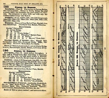 click to enlarge click to enlargeIG5185.jpg Itinerary, with gradient diagram, route 185, Kendal to Barrow, and route 187, Kendal to Keswick, Westmorland and Lancashire, 1898. item:- JandMN : 763.18 Image © see bottom of page |
|||
|
|
||||
| evidence:- | old strip map:- CTC 1911 (Roads) |
|||
| source data:- | Page 81 of Cyclists' Touring Club British Road Book new series vol.6, edited by F
B Sandford, published by Thomas Nelson and Sons, London etc, 1911.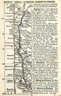 click to enlarge click to enlargeCTC281.jpg Strip road map, route 36, Kendal Ulverston Barrow-in-Furness, scale roughly 5 miles to 1 inch. Together with an itinerary and gradient diagram. item:- JandMN : 491.81 Image © see bottom of page |
|||
|
|
||||
| evidence:- | old strip map:- Geographia 1925 |
|||
| source data:- | Road book, with road strip maps and gradient diagrams, Premier Road Book of Great
Britain, by Alexander Gross and F Waite-Browne, published by Geographia, 55 Fleet
Street, London, about 1925?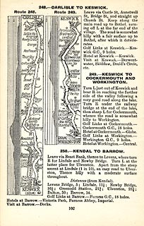 click to enlarge click to enlargeGE1102.jpg "250. - KENDAL TO BARROW." item:- Hampshire Museums : B1990.161.4 Image © see bottom of page |
|||
|
|
||||
 Act of Parliament Act of Parliament |
||||
|
|
||||
| evidence:- | old strip map:- Rumney 1899 |
|||
| source data:- | Road map, strip map, gradient diagram, and itinerary for Route III, Newby Bridge to
Furness Abbey and Barrow, Lancashire, scale about 2 miles to 1 inch, by A W Rumney,
published by George Philip and Son, 32 Fleet Street, London, and Liverpool, 1899.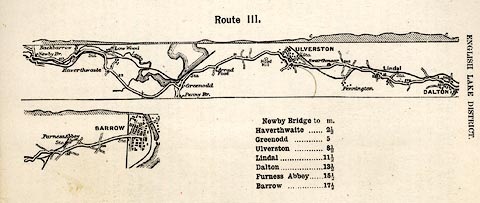 click to enlarge click to enlargeRUM105.jpg On p.22 of the Cyclist's Guide to the English Lake District, by A W Rumney. printed at top:- "Route III." item:- JandMN : 147.6 Image © see bottom of page |
|||
|
|
||||
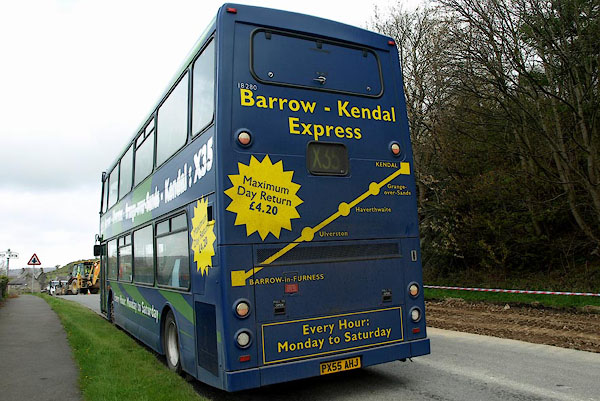 BPC36.jpg The Kendal Barrow bus passing through High Newton, Upper Allithwaite. (taken 26.4.2008) 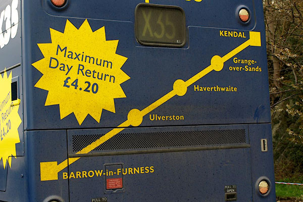 BPC37.jpg Bus map. (taken 26.4.2008) |
||||
|
|
||||
| places:- | Ulverston Lindal in Furness Dalton-in-Furness |
|||
|
|
||||
| places:- |
|
|||
|
||||
|
||||
|
||||
|
||||
|
||||
Lakes Guides menu.