 Old Cumbria Gazetteer
 |
 |
|
| Fellfoot Bridge, Little Langdale | ||
| Fellfoot Bridge | ||
| site name:- | Brathay, River | |
| locality:- | Little Langdale | |
| civil parish:- | Lakes (formerly Westmorland) | |
| county:- | Cumbria | |
| locality type:- | bridge | |
| coordinates:- | NY30000316 | |
| 1Km square:- | NY3003 | |
| 10Km square:- | NY30 | |
|
|
||
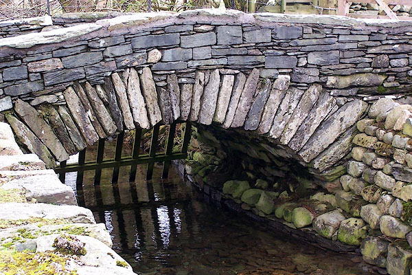 BNI92.jpg (taken 14.3.2007) |
||
|
|
||
| evidence:- | old map:- OS County Series (Wmd 25 11) placename:- Dalehead Bridge |
|
| source data:- | Maps, County Series maps of Great Britain, scales 6 and 25
inches to 1 mile, published by the Ordnance Survey, Southampton,
Hampshire, from about 1863 to 1948. |
|
|
|
||
| evidence:- | old map:- OS County Series (Lan 1 8) placename:- Fell Foot Bridge |
|
| source data:- | Maps, County Series maps of Great Britain, scales 6 and 25
inches to 1 mile, published by the Ordnance Survey, Southampton,
Hampshire, from about 1863 to 1948. |
|
|
|
||
| evidence:- | probably old drawing:- Aspland 1840s-60s |
|
| source data:- | Drawing, pencil and ink wash, Fellfoot Bridge? Fell Foot, Little Langdale, Westmorland,
by Theophilus Lindsey Aspland, 1849.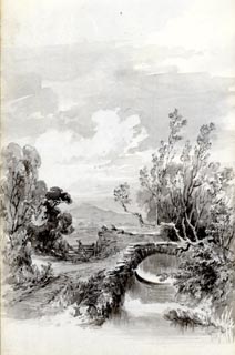 click to enlarge click to enlargeAS0161.jpg item:- Armitt Library : 1958.487.61 Image © see bottom of page |
|
|
|
||
 Lakes Guides menu.