 Old Cumbria Gazetteer
 |
 |
|
| Warwick Bridge, Warwick Bridge | ||
| Warwick Bridge | ||
| site name:- | Eden, River | |
| locality:- | Warwick Bridge | |
| civil parish:- | Wetheral (formerly Cumberland) | |
| county:- | Cumbria | |
| locality type:- | bridge | |
| coordinates:- | NY46925672 | |
| 1Km square:- | NY4656 | |
| 10Km square:- | NY45 | |
|
|
||
 BMN82.jpg (taken 25.8.2006) 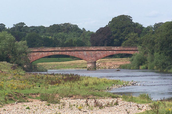 BMN85.jpg (taken 25.8.2006) |
||
|
|
||
| evidence:- | old map:- OS County Series (Cmd 24 2) placename:- Warwick Bridge |
|
| source data:- | Maps, County Series maps of Great Britain, scales 6 and 25
inches to 1 mile, published by the Ordnance Survey, Southampton,
Hampshire, from about 1863 to 1948. |
|
|
|
||
| evidence:- | old map:- Saxton 1579 |
|
| source data:- | Map, hand coloured engraving, Westmorlandiae et Cumberlandiae Comitatus ie Westmorland
and Cumberland, scale about 5 miles to 1 inch, by Christopher Saxton, London, engraved
by Augustinus Ryther, 1576, published 1579-1645.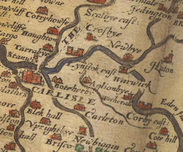 Sax9NY45.jpg item:- private collection : 2 Image © see bottom of page |
|
|
|
||
| evidence:- | old map:- Mercator 1595 (edn?) placename:- |
|
| source data:- | Map, hand coloured engraving, Northumbria, Cumberlandia, et
Dunelmensis Episcopatus, ie Northumberland, Cumberland and
Durham etc, scale about 6.5 miles to 1 inch, by Gerard Mercator,
Duisberg, Germany, about 1595. MER8CumD.jpg "" double across a stream; bridge, over the Eden item:- JandMN : 169 Image © see bottom of page |
|
|
|
||
| evidence:- | old map:- Jansson 1646 |
|
| source data:- | Map, hand coloured engraving, Cumbria and Westmoria, ie
Cumberland and Westmorland, scale about 3.5 miles to 1 inch, by
John Jansson, Amsterdam, Netherlands, 1646.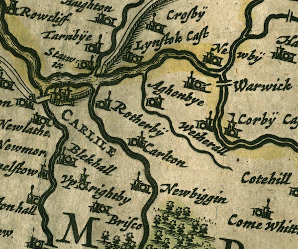 JAN3NY45.jpg Double line crossing the stream. item:- JandMN : 88 Image © see bottom of page |
|
|
|
||
| evidence:- | old map:- Ogilby 1675 (plate 86) |
|
| source data:- | Road strip map, uncoloured engraving, the Road from Tinmouth ...
to Carlisle, scale about 1 inch to 1 mile, by John Ogilby,
London, 1675.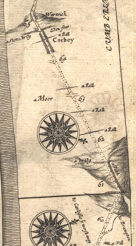 OG86m060.jpg In mile 64, Cumberland. Road crosses over:- "a Stone bridg Eden fluv:" no bridge is drawn. item:- JandMN : 73 Image © see bottom of page |
|
|
|
||
| evidence:- | old map:- Sanson 1679 |
|
| source data:- | Map, hand coloured engraving, Ancien Royaume de Northumberland
aujourdhuy Provinces de Nort, ie the Ancient Kingdom of
Northumberland or the Northern Provinces, scale about 9.5 miles
to 1 inch, by Nicholas Sanson, Paris, France, 1679. click to enlarge click to enlargeSAN2Cm.jpg double line over a stream; bridge item:- Dove Cottage : 2007.38.15 Image © see bottom of page |
|
|
|
||
| evidence:- | old map:- Seller 1694 (Cmd) |
|
| source data:- | Map, uncoloured engraving, Cumberland, scale about 12 miles to 1
inch, by John Seller, 1694. click to enlarge click to enlargeSEL9.jpg double line across a stream; bridge item:- Dove Cottage : 2007.38.89 Image © see bottom of page |
|
|
|
||
| evidence:- | old map:- Morden 1695 (Cmd) |
|
| source data:- | Map, uncoloured engraving, Cumberland, scale about 4 miles to 1
inch, by Robert Morden, 1695, published by Abel Swale, the
Unicorn, St Paul's Churchyard, Awnsham, and John Churchill, the
Black Swan, Paternoster Row, London, 1695-1715.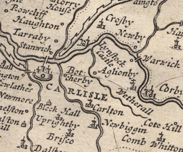 MD12NY45.jpg Double line over a stream, over the Eden at Warwick. item:- JandMN : 90 Image © see bottom of page |
|
|
|
||
| evidence:- | old map:- Bowen 1720 (plate 232) placename:- Warwick Stone Bridge |
|
| source data:- | Road strip map, road map, pl.232, part of The Road from Tinmouth
to Carlisle, scale about 2 miles to 1 inch, with sections in
Northumberland and Cumberland, published by Emanuel Bowen, St
Katherines, London, 1720.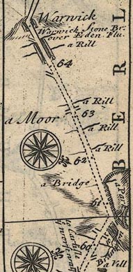 B232m60.jpg "Warwick Stone Br. over Eden Flu; mile 64½." item:- JandMN : 65.232 Image © see bottom of page |
|
|
|
||
| evidence:- | old map, descriptive text:- Bowen 1720 (plate 232) |
|
| source data:- | Road book, Britannia Depicta Or Ogilby Improv'd, including road
strip maps with sections in Westmorland and Cumberland, scale
about 2 miles to 1 inch, derived from maps by Ogilby, 1675, also
a county map of Westmorland, scale about 8 miles to 1 inch, and
of Cumberland, scale about 16.5 miles to 1 inch, each with text,
by John Owen, published by Emanuel Bowen, London, 1720;
published 1720-64. "Warwick Stone Bridge (at 64¾) was built not many years since at the joint & equal expence of the Salkelds and Richmonds, two ancient and worthy Families in this County; out of a generous regard to ye conveniency &safety of Travellers." |
|
|
|
||
| evidence:- | old map:- Badeslade 1742 placename:- |
|
| source data:- | Map, uncoloured engraving, A Map of Cumberland North from
London, scale about 11 miles to 1 inch, with descriptive text,
by Thomas Badeslade, London, engraved and published by William
Henry Toms, Union Court, Holborn, London, 1742. click to enlarge click to enlargeBD10.jpg "" double line across a stream item:- JandMN : 115 Image © see bottom of page |
|
|
|
||
| evidence:- | descriptive text:- Simpson 1746 |
|
| source data:- | Atlas, three volumes of maps and descriptive text published as
'The Agreeable Historian, or the Compleat English Traveller
...', by Samuel Simpson, 1746. goto source goto source"... In the last Age, the Richmonds and Salkelds bearing the Expence equally, built a very strong Stone Bridge over the Eden for the Convenience of Travellers. ..." |
|
|
|
||
| evidence:- | old map:- Bowen and Kitchin 1760 |
|
| source data:- | Map, hand coloured engraving, A New Map of the Counties of
Cumberland and Westmoreland Divided into their Respective Wards,
scale about 4 miles to 1 inch, by Emanuel Bowen and Thomas
Kitchin et al, published by T Bowles, Robert Sayer, and John
Bowles, London, 1760.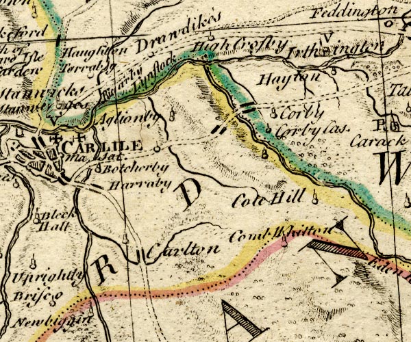 BO18NY45.jpg road cross the Eden item:- Armitt Library : 2008.14.10 Image © see bottom of page |
|
|
|
||
| evidence:- | old map:- Donald 1774 (Cmd) placename:- Warwick Bridge |
|
| source data:- | Map, hand coloured engraving, 3x2 sheets, The County of Cumberland, scale about 1
inch to 1 mile, by Thomas Donald, engraved and published by Joseph Hodskinson, 29
Arundel Street, Strand, London, 1774.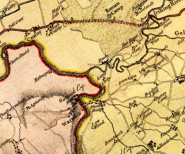 D4NY45NE.jpg "Warwick Bridge" double line across a river; a bridge item:- Carlisle Library : Map 2 Image © Carlisle Library |
|
|
|
||
| evidence:- | old text:- Camden 1789 |
|
| source data:- | Book, Britannia, or A Chorographical Description of the Flourishing Kingdoms of England,
Scotland, and Ireland, by William Camden, 1586, translated from the 1607 Latin edition
by Richard Gough, published London, 1789. goto source Page 174:- "..." "... Warwic ... in the last age a strong stone bridge was built at the expence of the Salkelds and Richmonds: ..." |
|
|
|
||
| evidence:- | old map:- Bell 1892 placename:- Warwick Bridge |
|
| source data:- | Map, colour lithograph, Road Map of Cumberland, by George Joseph
Bell, scale about 2.5 miles to 1 inch, printed by Charles
Thurnam and Sons, Carlisle, Cumberland, 1892.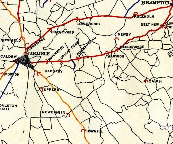 BEL9NY45.jpg "WARWICK" bridge symbol Road map of Cumberland showing County Bridges item:- Carlisle Library : Map 38 Image © Carlisle Library |
|
|
|
||
| evidence:- | database:- Listed Buildings 2010 placename:- Warwick Bridge |
|
| source data:- | courtesy of English Heritage "WARWICK BRIDGE / / A69 / WETHERAL / CARLISLE / CUMBRIA / II / 77747 / NY4691656720" |
|
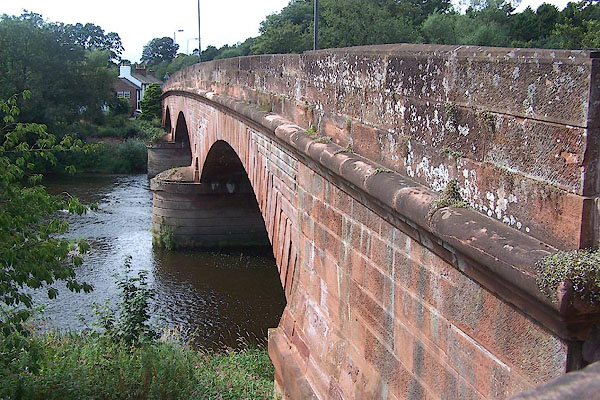
| source data:- | courtesy of English Heritage "Road bridge. Begun 1833, completed 1835, by Francis Giles, built by William Denton. Red sandstone ashlar. 2 piers with rounded cutwaters supporting 3 shallow segmental arches: bold string course and solid parapets: channelled joints to masonry and voussoirs. Inscription stone in both parapets records architect and builder with dates. Carries 2 lines of road traffic. A bridge of excellent architectural and engineering quality, by the architect of Corby Bridge. Replaced C16 bridge, slightly upstream, which in turn replaced a medieval bridge: on an important crossing point over the River Eden for the approach to Carlisle from the east. Pevsner, Buildings of England, wrongly ascribes the bridge to Dobson and dates it 1837." |
|
|
|
||
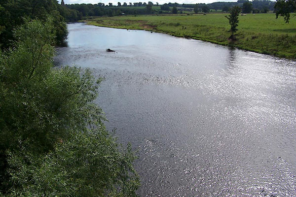 BMN86.jpg View of river. (taken 25.8.2006) |
||
|
|
||
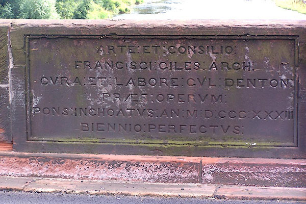 BMN83.jpg Sandstone plaque on south parapet:- "ARTE ET CONSILIO FRANCISCI GILES ARCH CVRA ET LABORE CVL DENTON PRAEF OPERVM PONS INCHOATVS AN M D CCC XXX III BIENNIO PERFECTVS" (taken 25.8.2006) 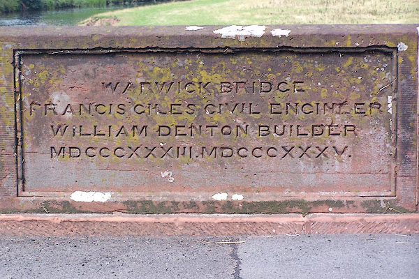 BMN84.jpg Sandstone plaque on north parapet:- "WARWICK BRIDGE FRANCIS GILES CIVIL ENGINEER WILLIAM DENTON BUIDLER MDCCCXXXIII MDCCCXXXV" (taken 25.8.2006) |
||
|
|
||
Lakes Guides menu.