 Old Cumbria Gazetteer
 |
 |
|
| roman road 7c, Cumbria | ||
| locality:- | Ribchester | |
| county:- | Lancashire | |
| locality:- | Low Borrow Bridge | |
| county:- | Cumbria | |
| locality type:- | roman road | |
| locality type:- | road | |
| 10Km square:- | SD63 | |
| 10Km square:- | SD64 | |
| 10Km square:- | SD65 | |
| 10Km square:- | SD66 | |
| 10Km square:- | SD67 | |
| 10Km square:- | SD68 | |
| 10Km square:- | SD69 | |
| 10Km square:- | NY60 | |
| references:- | Margary, Ivan D: 1973 (3rd edn): Roman Roads in Britain: Baker, John (London):: ISBN
0 212 97001 1; describes the route in moderate detail |
|
|
|
||
| evidence:- | old map:- Stukeley 1723 |
|
| source data:- | Road map, uncoloured engraving, the Antonine Itineraries through
Britain, scale about 55 miles to 1 inch, plotted by William
Stukeley, 1723, published London, 1724.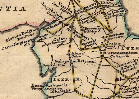 click to enlarge click to enlargeStu1Cm.jpg "ITER X." item:- Hampshire Museums : FA2001.171 Image © see bottom of page |
|
|
|
||
| evidence:- | descriptive text:- West 1778 (11th edn 1821) |
|
| source data:- | Guide book, A Guide to the Lakes, by Thomas West, published by
William Pennington, Kendal, Cumbria once Westmorland, and in
London, 1778 to 1821. goto source goto sourceTour to the Caves in the West Riding of Yorkshire, late 18th century Page 243:- "..." "... The Roman road is easily traced from Ribchester into Yorkshire, running on the north side of Slaidburn, through Crossa-Greta, then on the north side of Tatham Chapel, through Bentham, to Overborough; afterwards the Roman road goes through Casterton and Middleton, and, as some think, by Borrow-bridge and Orton, to Apulby. Others, and perhaps from better reasons, are of opinion, the road went by Sedbergh, or Sedburgh, [2] over Blewcaster, along Ravenstonedale-street, and through Kirkby-Stephen, to Brough or Burgh. For Antoninus's tenth Itinerary runs from Glanoventa or Lanchester, in the county of Durham, by Galacum, Bremetonacae, Coccium, Mancunium or Manchester, to Glenovento or Draton, in the county of Salop. In various places by the side of this road are high artificial mounts of earth, which were without doubt the stations of centinels, to prevent any insurrections, or being surprised by an enemy: they may be now seen entire at Burton-in-Lons-" "[2] Chester, or caster, is derived from the Latin word castrum, or camp. Street is derived from the Latin word stratum, or military road, or causeway. Borough, or Burgh, from the Greek word burgos, or watch tower." goto sourcePage 244:- "[Burton-in-Lons]dale, Overborough, Kirkby-Lonsdale, and Sedbergh. There are several lateral ones, as at Lune-bridge near Hornby, at Melling, and Wennington. ..." |
|
|
|
||
| :- |
References cited by Margary for the whole route from Ribchester |
|
| Watkin, W T: 1883: Roman Lancashire Ross, P:: Bradford Ant[ ]: vol.6: p.243 Harrison, W:: Lancashire and Cheshire Antiquarian Society Transactions: vol.31: p.69 Slinger, J S:: Lancashire and Cheshire Antiquarian Society Transactions: vol.12: p.122 Watkin, W T:: CWAAS: vol.7: p.109 Birley, E:: CWAAS: new series vol.53: p.52 Ewbank, J M:: CWAAS: new series vol.60; p.28 Macadam, E M L:: CWAAS: new series vol.64: p.76 |
||
|
|
||
| mapping:- | The parts in Yorkshire and Westmorland, approximately:- | |
| note:- | from the south, Manchester | |
| place identity:- | [Long Level, Lancashire] | |
| place identity:- | Gowrey, Casterton |
|
| place identity:- | Wandales Lane, Casterton |
|
| place:- | SD62708100 / Cross Stone / Casterton / Cumbria | |
| place:- | SD62558178 | |
| place identity:- | [settlement, Barbon] | |
| place:- | SD62438200 | |
| place:- | SD62258253 / Hodge Bridge / Barbon / Cumbrai | |
| place:- | SD62108303 | |
| place:- | SD62028436 | |
| to link:- | roman milestone, Middleton |
|
| place identity:- | Low Stockdale Bridge, Middleton |
|
| place:- | SD62758821 | |
| place identity:- | Jordan Lane, Middleton |
|
| place identity:- | Lords' Dub, Sedbergh |
|
| place identity:- | Ingmire Back Lane, Sedbergh |
|
| place:- | SD63839325 | |
| place identity:- | Howgill Lane, Sedbergh |
|
| place identity:- | Fairmile Road, Tebay |
|
| place:- | SD62419948 | |
| place identity:- | Salterwath Bridge, Tebay |
|
| to link:- | roman fort, Low Borrow Bridge (passing by the east gate) |
|
|
|
||
Lakes Guides menu.