 Old Cumbria Gazetteer
 |
 |
|
| roman fort, Low Borrow Bridge | ||
| Alone | ||
| locality:- | Low Borrowbridge | |
| civil parish:- | Tebay (formerly Westmorland) | |
| county:- | Cumbria | |
| locality type:- | roman fort | |
| coordinates:- | NY60960127 | |
| 1Km square:- | NY6001 | |
| 10Km square:- | NY60 | |
|
|
||
| evidence:- | old map:- Jefferys 1770 (Wmd) |
|
| source data:- | Map, 4 sheets, The County of Westmoreland, scale 1 inch to 1
mile, surveyed 1768, and engraved and published by Thomas
Jefferys, London, 1770.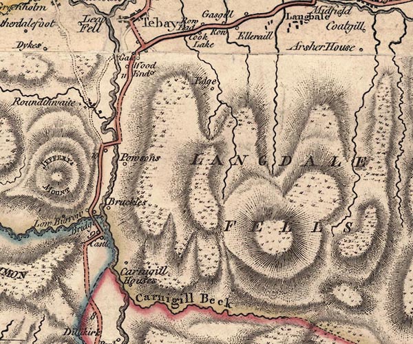 J5NY60SW.jpg "Castle" circle; roman fort? item:- National Library of Scotland : EME.s.47 Image © National Library of Scotland |
|
|
|
||
| evidence:- | old map:- Hall 1820 (Wmd) placename:- Castle |
|
| source data:- | Map, hand coloured engraving, Westmoreland ie Westmorland, scale
about 14.5 miles to 1 inch, by Sidney Hall, London, 1820,
published by Samuel Leigh, 18 Strand, London, 1820-31. click to enlarge click to enlargeHA18.jpg "Castle" circle, italic lowercase text; settlement item:- Armitt Library : 2008.14.58 Image © see bottom of page |
|
|
|
||
| evidence:- | descriptive text:- Otley 1823 (8th edn 1849) placename:- Castle Field placename:- Alone |
|
| source data:- | Guide book, A Concise Description of the English Lakes, the
mountains in their vicinity, and the roads by which they may be
visited, with remarks on the mineralogy and geology of the
district, by Jonathan Otley, published by the author, Keswick,
Cumberland now Cumbria, by J Richardson, London, and by Arthur
Foster, Kirkby Lonsdale, Cumbria, 1823; published 1823-49,
latterly as the Descriptive Guide to the English Lakes. goto source goto sourcePage 189:- "[Low Borrow Bridge] ... Behind the house is a Roman Station, now called Castle Field, consisting of a square inclosure, 360 feet in length, and 300 in breadth. On the sides facing the east, north, and west, are the remains of the walls; and on the latter side, the traces of two fosses. Where the east gate stood, is a stone, which was dug out a few years ago, and it is evidently one of the original sockets, the groove for the hinge remaining as perfect as if freshly cut. Sherds of Roman pottery have been found; and a silver coin of the reign of Aurelian. From the style of the cutting or quartering of the facing stones, (many of which have been used in building the outhouses, in order to preserve them,) there is no doubt that this station is coeval with Overborough, and is the site of the long lost and much disputed Alone. The very name seems to warrant this opinion; for it is the first station on the Lune (or Lone); and what so natural as to give it the title from the river which watered its walls? The remains of several buildings have been discovered between the eastern wall and the river." |
|
|
|
||
| evidence:- | old map:- Ford 1839 map |
|
| source data:- | Map, uncoloured engraving, Map of the Lake District of
Cumberland, Westmoreland and Lancashire, scale about 3.5 miles
to 1 inch, published by Charles Thurnam, Carlisle, and by R
Groombridge, 5 Paternoster Row, London, 3rd edn 1843.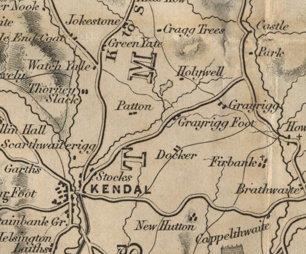 FD02SD59.jpg "Castle" item:- JandMN : 100.1 Image © see bottom of page |
|
|
|
||
| evidence:- | site plan:- Historical Monuments 1936 placename:- Low Borrowbridge Roman Station |
|
| source data:- | Site plan, uncoloured lithograph, Grayrigg, Low Borrowbridge Roman Station, Tebay,
Westmorland, scale about 1 to 2500, published by Royal Commission on Historical Monuments
England, London, 1936.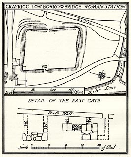 click to enlarge click to enlargeHMW070.jpg On p.100 of the Inventory of the Historical Monuments in Westmorland. printed, top "GRAYRIGG, LOW BORROWBRIDGE ROMAN STATION" RCHME no. Wmd, Grayrigg 1 item:- Armitt Library : A745.70 Image © see bottom of page |
|
|
|
||
Lakes Guides menu.