Old Cumbria Gazetteer
 |
 |
|
||
| Portinscale, Above Derwent | ||||
| Portinscale | ||||
| civil parish:- | Above Derwent (formerly Cumberland) | |||
| county:- | Cumbria | |||
| locality type:- | locality | |||
| locality type:- | buildings | |||
| coordinates:- | NY25202355 (etc) | |||
| 1Km square:- | NY2523 | |||
| 10Km square:- | NY22 | |||
|
|
||||
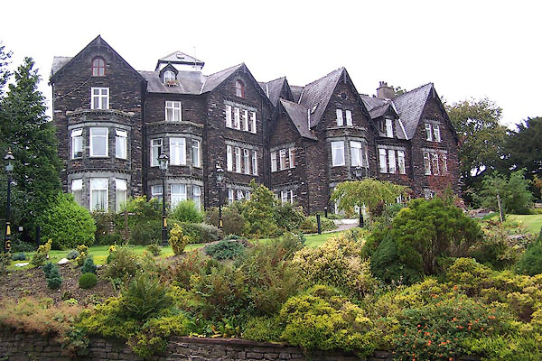
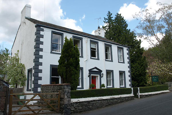
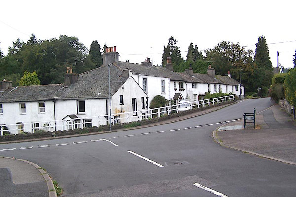 BMR85.jpg One side of the street. (taken 22.9.2006) 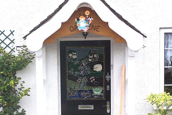 BMR81.jpg The door of Oakdene, on the Main Street. (taken 22.9.2006) |
||||
|
|
||||
| evidence:- | old map:- OS County Series (Cmd 64 5) placename:- Portinscales |
|||
| source data:- | Maps, County Series maps of Great Britain, scales 6 and 25
inches to 1 mile, published by the Ordnance Survey, Southampton,
Hampshire, from about 1863 to 1948. |
|||
|
|
||||
| evidence:- | old map:- Saxton 1579 placename:- Portinskale |
|||
| source data:- | Map, hand coloured engraving, Westmorlandiae et Cumberlandiae Comitatus ie Westmorland
and Cumberland, scale about 5 miles to 1 inch, by Christopher Saxton, London, engraved
by Augustinus Ryther, 1576, published 1579-1645.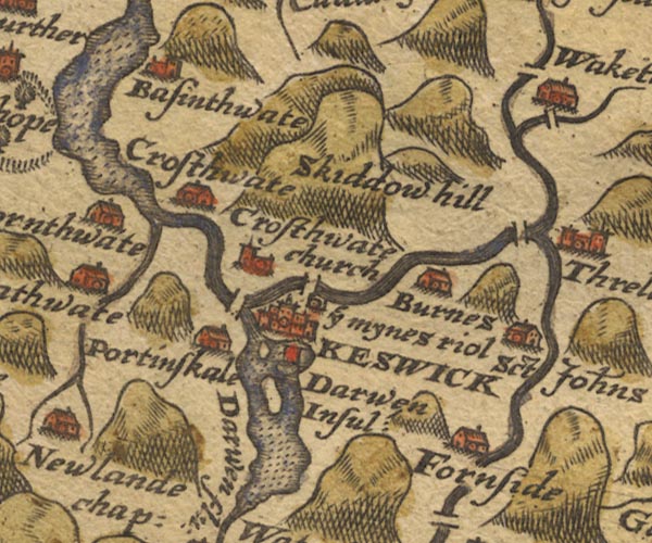 Sax9NY22.jpg Building, symbol for a hamlet, which may or may not have a nucleus. "Portinskale" item:- private collection : 2 Image © see bottom of page |
|||
|
|
||||
| evidence:- | old map:- Mercator 1595 (edn?) placename:- Portinskale |
|||
| source data:- | Map, hand coloured engraving, Northumbria, Cumberlandia, et
Dunelmensis Episcopatus, ie Northumberland, Cumberland and
Durham etc, scale about 6.5 miles to 1 inch, by Gerard Mercator,
Duisberg, Germany, about 1595. MER8CumF.jpg "Portinskale" circle item:- JandMN : 169 Image © see bottom of page |
|||
|
|
||||
| evidence:- | old map:- Speed 1611 (Cmd) placename:- Portinskal |
|||
| source data:- | Map, hand coloured engraving, Cumberland and the Ancient Citie
Carlile Described, scale about 4 miles to 1 inch, by John Speed,
1610, published by J Sudbury and George Humble, Popes Head
Alley, London, 1611-12.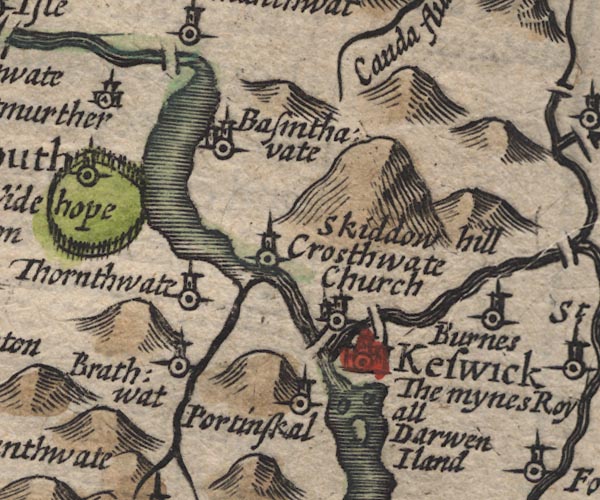 SP11NY22.jpg "Portinskal" circle, tower item:- private collection : 16 Image © see bottom of page |
|||
|
|
||||
| evidence:- | old map:- Jansson 1646 placename:- Portinskal |
|||
| source data:- | Map, hand coloured engraving, Cumbria and Westmoria, ie
Cumberland and Westmorland, scale about 3.5 miles to 1 inch, by
John Jansson, Amsterdam, Netherlands, 1646. JAN3NY22.jpg "Portinskal" Buildings and tower. item:- JandMN : 88 Image © see bottom of page |
|||
|
|
||||
| evidence:- | old map:- Morden 1695 (Cmd) placename:- Portinskal |
|||
| source data:- | Map, uncoloured engraving, Cumberland, scale about 4 miles to 1
inch, by Robert Morden, 1695, published by Abel Swale, the
Unicorn, St Paul's Churchyard, Awnsham, and John Churchill, the
Black Swan, Paternoster Row, London, 1695-1715.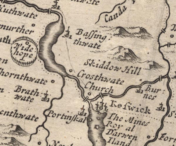 MD12NY22.jpg "Portinskal" Circle, building and tower. item:- JandMN : 90 Image © see bottom of page |
|||
|
|
||||
| evidence:- | old map:- Badeslade 1742 placename:- Portinskall |
|||
| source data:- | Map, uncoloured engraving, A Map of Cumberland North from
London, scale about 11 miles to 1 inch, with descriptive text,
by Thomas Badeslade, London, engraved and published by William
Henry Toms, Union Court, Holborn, London, 1742. click to enlarge click to enlargeBD10.jpg "Portinskall" circle, italic lowercase text; village, hamlet or locality item:- JandMN : 115 Image © see bottom of page |
|||
|
|
||||
| evidence:- | old map:- Bowen and Kitchin 1760 placename:- Portinskall |
|||
| source data:- | Map, hand coloured engraving, A New Map of the Counties of
Cumberland and Westmoreland Divided into their Respective Wards,
scale about 4 miles to 1 inch, by Emanuel Bowen and Thomas
Kitchin et al, published by T Bowles, Robert Sayer, and John
Bowles, London, 1760.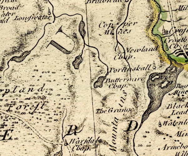 BO18NY11.jpg "Portinskall" circle, tower item:- Armitt Library : 2008.14.10 Image © see bottom of page |
|||
|
|
||||
| evidence:- | old map:- Donald 1774 (Cmd) placename:- Portingscale |
|||
| source data:- | Map, hand coloured engraving, 3x2 sheets, The County of Cumberland, scale about 1
inch to 1 mile, by Thomas Donald, engraved and published by Joseph Hodskinson, 29
Arundel Street, Strand, London, 1774. D4NY22SW.jpg "Portingscale" block or blocks, labelled in lowercase; a hamlet or just a house item:- Carlisle Library : Map 2 Image © Carlisle Library |
|||
|
|
||||
| evidence:- | descriptive text:- West 1778 (11th edn 1821) |
|||
| source data:- | Guide book, A Guide to the Lakes, by Thomas West, published by
William Pennington, Kendal, Cumbria once Westmorland, and in
London, 1778 to 1821. goto source goto sourceAddendum; Mr Gray's Journal, 1769 Page 207:- "..." "Oct. 5. ... I took my way through Portinscale village to the Park, ..." |
|||
|
|
||||
| evidence:- | old map:- Crosthwaite 1783-94 (Der) placename:- Portinscale |
|||
| source data:- | Map, uncoloured engraving, An Accurate Map of the Matchless Lake
of Derwent, ie Derwent Water, scale about 3 inches to 1 mile, by
Peter Crosthwaite, Keswick, Cumberland, 1783, version published
1800. CT2NY22K.jpg "PORTINSCALE" item:- Armitt Library : 1959.191.3 Image © see bottom of page |
|||
|
|
||||
| evidence:- | old map:- West 1784 map placename:- Portinscale |
|||
| source data:- | Map, hand coloured engraving, A Map of the Lakes in Cumberland,
Westmorland and Lancashire, scale about 3.5 miles to 1 inch,
engraved by Paas, 53 Holborn, London, about 1784.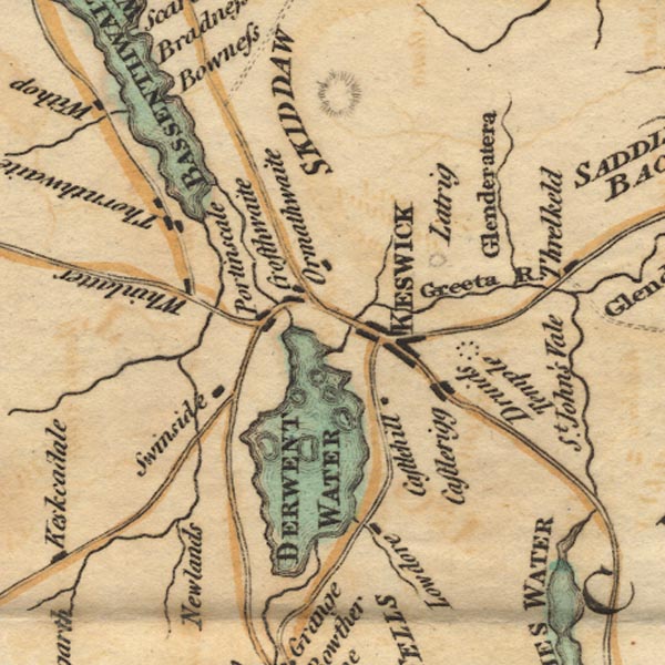 Ws02NY22.jpg item:- Armitt Library : A1221.1 Image © see bottom of page |
|||
|
|
||||
| evidence:- | old text:- Clarke 1787 placename:- Portingsill |
|||
| source data:- | Guide book, A Survey of the Lakes of Cumberland, Westmorland,
and Lancashire, written and published by James Clarke, Penrith,
Cumberland, and in London etc, 1787; published 1787-93. goto source Page 91:- "..." "... Leaving Keswick, we come to the little village of Portingsgill, which we pass ..." |
|||
|
|
||||
| evidence:- | old map:- Clarke 1787 map (Der) placename:- Portinskill |
|||
| source data:- | Map, uncoloured engraving, Map of Derwentwater and its Environs,
scale about 13 ins to 1 mile, by James Clarke, engraved by S J
Neele, published by James Clarke, Penrith, Cumberland and in
London etc, 1787.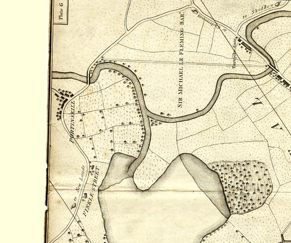 CL152523.jpg "PORTINSKILL" group of buildings, and trees item:- private collection : 169 Image © see bottom of page |
|||
|
|
||||
| evidence:- | road book:- Cary 1798 (2nd edn 1802) placename:- Portinscale |
|||
| source data:- | Road book, itineraries, Cary's New Itinerary, by John Cary, 181
Strand, London, 2nd edn 1802. goto source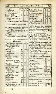 click to enlarge click to enlargeC38317.jpg page 317-318 "Portinscale" item:- JandMN : 228.1 Image © see bottom of page |
|||
|
|
||||
| evidence:- | old map:- Cooke 1802 placename:- Portincastle |
|||
| source data:- | Map, Cumberland, scale about 15.5 miles to 1 inch, by George
Cooke, 1802, bound in Gray's New Book of Roads, 1824, published
by Sherwood, Jones and Co, Paternoster Road, London, 1824. click to enlarge click to enlargeGRA1Cd.jpg "Portincastle" blocks, italic lowercase text, village, hamlet, locality item:- Hampshire Museums : FA2000.62.2 Image © see bottom of page |
|||
|
|
||||
| evidence:- | old map:- Laurie and Whittle 1806 placename:- Portinscale |
|||
| source data:- | Road map, Completion of the Roads to the Lakes, scale about 10
miles to 1 inch, by Nathaniel Coltman? 1806, published by Robert
H Laurie, 53 Fleet Street, London, 1834. click to enlarge click to enlargeLw18.jpg "Portinscale 295" village or other place; distance from London item:- private collection : 18.18 Image © see bottom of page |
|||
|
|
||||
| evidence:- | old map:- Wallis 1810 (Cmd) placename:- Portinscale |
|||
| source data:- | Road map, hand coloured engraving, Cumberland, scale about 16
miles to 1 inch, by James Wallis, 77 Berwick Stree, Soho,
London, 1810. click to enlarge click to enlargeWL13.jpg "Portinscale" village, hamlet, house, ... item:- Dove Cottage : 2009.81.10 Image © see bottom of page |
|||
|
|
||||
| evidence:- | old map:- Otley 1818 placename:- Portinscale |
|||
| source data:- | Map, uncoloured engraving, The District of the Lakes,
Cumberland, Westmorland, and Lancashire, scale about 4 miles to
1 inch, by Jonathan Otley, 1818, engraved by J and G Menzies,
Edinburgh, Scotland, published by Jonathan Otley, Keswick,
Cumberland, et al, 1833.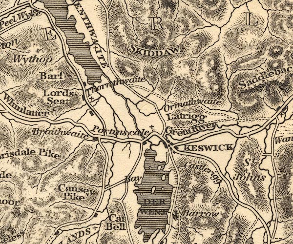 OT02NY22.jpg item:- JandMN : 48.1 Image © see bottom of page |
|||
|
|
||||
| evidence:- | old print:- Green 1822 (plate 23) placename:- Portinscale item:- barn |
|||
| source data:- | Print, uncoloured soft ground etching, Portinscale, Above Derwent, Cumberland, by
William Green, Ambleside, Westmorland, 1822.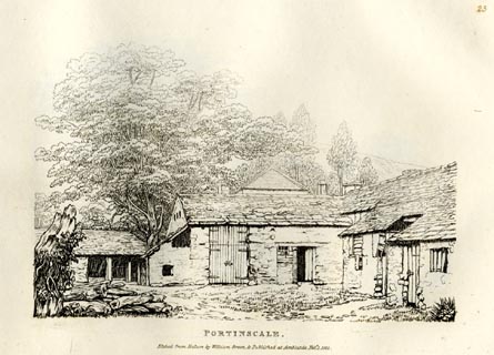 click to enlarge click to enlargeGN0823.jpg Perhaps part of Portinscale House? Plate 23 in Forty Etchings from Nature. printed at bottom:- "PORTINSCALE. / Etched from Nature by William Green, &Published at Ambleside, Feby. 1, 1822." item:- Armitt Library : A6644.23 Image © see bottom of page |
|||
|
|
||||
| evidence:- | old print:- Green 1822 (plate 24) placename:- Portinscale item:- barn |
|||
| source data:- | Print, uncoloured etching, Portinscale, Above Derwent, Cumberland, by William Green,
Ambleside, Westmorland, 1822.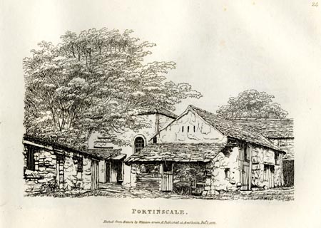 click to enlarge click to enlargeGN0824.jpg Perhaps part of Portinscale House? Plate 24 in Forty Etchings from Nature. printed at bottom:- "PORTINSCALE. / Etched from Nature by William Green, &Published at Ambleside, Feby. 1, 1822." item:- Armitt Library : A6644.24 Image © see bottom of page |
|||
|
|
||||
| evidence:- | old print:- Green 1822 (plate 25) placename:- Portinscale item:- rainwater butt |
|||
| source data:- | Print, uncoloured soft ground etching, Village of Portinscale, Above Derwent, Cumberland,
by William Green, Ambleside, Westmorland, 1822.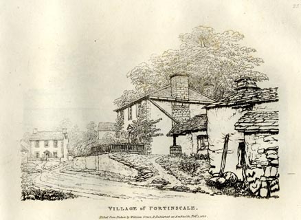 click to enlarge click to enlargeGN0825.jpg Plate 25 in Forty Etchings from Nature. printed at bottom:- "VILLAGE of PORTINSCALE. / Etched from Nature by William Green, &Published at Ambleside, Feby. 1, 1822." item:- Armitt Library : A6644.25 Image © see bottom of page |
|||
|
|
||||
| evidence:- | old print:- Green 1822 (plate 26) placename:- Portinscale |
|||
| source data:- | Print, uncoloured soft ground etching, Portinscale, Above Derwent, Cumberland, by
William Green, Ambleside, Westmorland, 1822.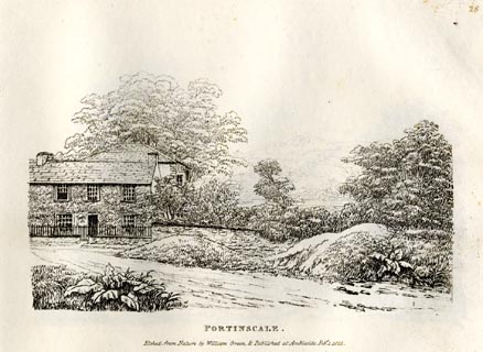 click to enlarge click to enlargeGN0826.jpg Plate 26 in Forty Etchings from Nature. printed at bottom:- "PORTINSCALE. / Etched from Nature by William Green, &Published at Ambleside, Feby. 1, 1822." item:- Armitt Library : A6644.26 Image © see bottom of page |
|||
|
|
||||
| evidence:- | descriptive text:- Ford 1839 (3rd edn 1843) placename:- Portinscale |
|||
| source data:- | Guide book, A Description of Scenery in the Lake District, by
Rev William Ford, published by Charles Thurnam, Carlisle, by W
Edwards, 12 Ave Maria Lane, Charles Tilt, Fleet Street, William
Smith, 113 Fleet Street, London, by Currie and Bowman,
Newcastle, by Bancks and Co, Manchester, by Oliver and Boyd,
Edinburgh, and by Sinclair, Dumfries, 1839. goto source Page 166:- "..." "Portinscale is a small village, near the foot of Derwent Water. Near it are situated the villas" goto sourcePage 167:- "of Derwent Bay, Derwent Bank, and Derwent Lodge. From the neighbouring heights may be viewed the lakes of Derwent Water and Bassenthwaite, with all the finely-wooded and fertile country reaching from Swinside to Skiddaw." |
|||
|
|
||||
| evidence:- | old map:- Ford 1839 map placename:- Portinscale |
|||
| source data:- | Map, uncoloured engraving, Map of the Lake District of
Cumberland, Westmoreland and Lancashire, scale about 3.5 miles
to 1 inch, published by Charles Thurnam, Carlisle, and by R
Groombridge, 5 Paternoster Row, London, 3rd edn 1843.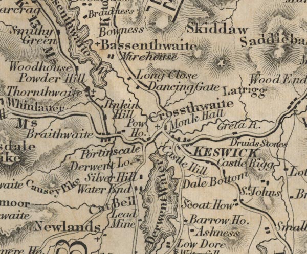 FD02NY22.jpg "Portinscale" item:- JandMN : 100.1 Image © see bottom of page |
|||
|
|
||||
| evidence:- | old map:- Garnett 1850s-60s H placename:- Portinscale |
|||
| source data:- | Map of the English Lakes, in Cumberland, Westmorland and
Lancashire, scale about 3.5 miles to 1 inch, published by John
Garnett, Windermere, Westmorland, 1850s-60s. GAR2NY22.jpg "Portinscale" blocks, settlement item:- JandMN : 82.1 Image © see bottom of page |
|||
|
|
||||
 Martineau Directory 1855 Martineau Directory 1855 |
||||
|
|
||||
| evidence:- | old text:- Martineau 1855 |
|||
| source data:- | Guide book, A Complete Guide to the English Lakes, by Harriet
Martineau, published by John Garnett, Windermere, Westmorland,
and by Whittaker and Co, London, 1855; published 1855-76. goto source Page 83:- "... The villages along the road, beginning with Portinscale, will exhibit their own evidence of the employment of the inhabitants in the woollen manufacture; an ancient staple of the town and district, as is shown by the inscription which has come down from the olden time, engraved on a flagstone." "" ""May God Almighty grant His aid" "To Keswick and its woollen trade."" |
|||
|
|
||||
| evidence:- | old print:- placename:- Portinscale |
|||
| source data:- | Print, uncoloured lithograph, Portinscale, Above Derwent, Cumberland, perhaps 1900s-10s?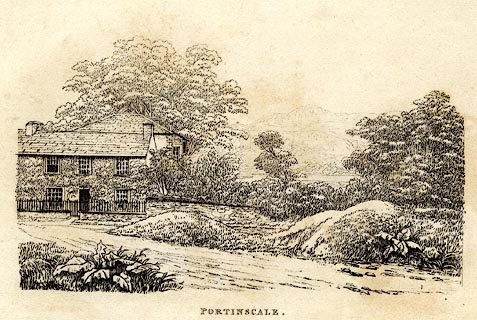 click to enlarge click to enlargePR0584.jpg printed at bottom:- "PORTINSCALE." item:- Dove Cottage : 2008.107.532 Image © see bottom of page |
|||
|
|
||||
| notes:- |
One local boy, John Graves, became Lord Mayor of Manchester. He retired to Portinscale
and built a mansion by the lake, ignoring warnings about the boggy ground. His mansion
sank. |
|||
|
|
||||
| places:- |
|
|||
|
||||
|
||||
|
||||
|
||||
|
||||
|
||||
|
||||
|
||||
|
||||
|
||||
|
||||
|
||||
|
||||
|
||||
|
||||
|
||||
|
||||
|
||||
|
||||
|
||||
|
||||
|
||||
|
||||
Lakes Guides menu.