 Old Cumbria Gazetteer
 |
 |
|
| Pendragon Castle, Mallerstang | ||
| Pendragon Castle | ||
| locality:- | Mallerstang | |
| civil parish:- | Mallerstang (formerly Westmorland) | |
| county:- | Cumbria | |
| locality type:- | castle | |
| coordinates:- | NY78180263 | |
| 1Km square:- | NY7802 | |
| 10Km square:- | NY70 | |
|
|
||
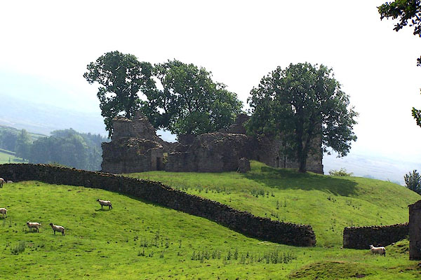 BJQ79.jpg (taken 24.7.2005) 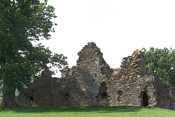 BJQ80.jpg (taken 24.7.2005) |
||
|
|
||
| evidence:- | old map:- OS County Series (Wmd 30 11) placename:- Pendragon Castle |
|
| source data:- | Maps, County Series maps of Great Britain, scales 6 and 25
inches to 1 mile, published by the Ordnance Survey, Southampton,
Hampshire, from about 1863 to 1948. |
|
|
|
||
| evidence:- | old map:- Gough 1350s-60s placename:- Pen-dragon |
|
| source data:- | Map, colour photozincograph copy, reduced size facsimile, Gough
Map of Britain, scale about 28.5 miles to 1 inch, published by
the Ordnance Survey, Southampton, Hampshire, 1875. click to enlarge click to enlargeGgh1Cm.jpg item:- JandMN : 33 Image © see bottom of page |
|
|
|
||
| evidence:- | old map:- Gough 1350s-60s placename:- Pen-dragon |
|
| source data:- | Map, lithograph facsimile, Gough Map of Britain, 20 miles to 1
inch? published by the Ordnance Survey, Southampton, Hampshire,
1935. click to enlarge click to enlargeGgh2Cm.jpg item:- JandMN : 34 Image © see bottom of page |
|
|
|
||
| evidence:- | old map:- Saxton 1579 placename:- Pendragon Castle |
|
| source data:- | Map, hand coloured engraving, Westmorlandiae et Cumberlandiae Comitatus ie Westmorland
and Cumberland, scale about 5 miles to 1 inch, by Christopher Saxton, London, engraved
by Augustinus Ryther, 1576, published 1579-1645.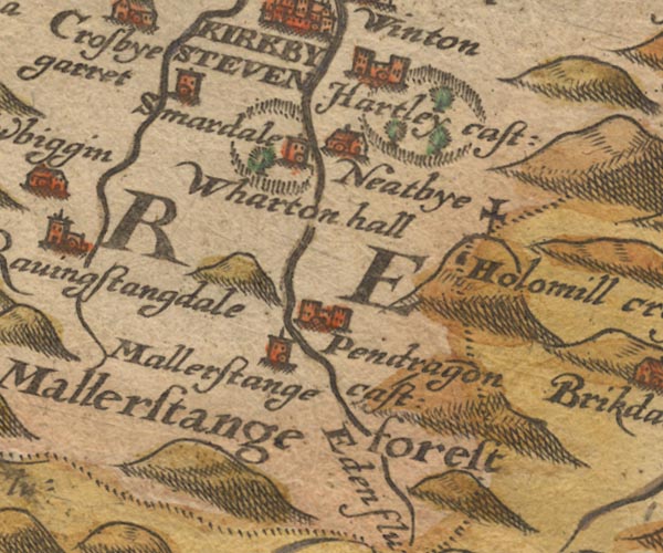 Sax9NY70.jpg Building with two towers, symbol for a castle. "Pendragon cast:" item:- private collection : 2 Image © see bottom of page |
|
|
|
||
| evidence:- | old map:- Mercator 1595 (edn?) placename:- Pendragon Castle |
|
| source data:- | Map, hand coloured engraving, Westmorlandia, Lancastria, Cestria
etc, ie Westmorland, Lancashire, Cheshire etc, scale about 10.5
miles to 1 inch, by Gerard Mercator, Duisberg, Germany, 1595,
edition 1613-16. MER5WmdA.jpg "Pendragon ca." circle, building/s, tower, tinted red item:- Armitt Library : 2008.14.3 Image © see bottom of page |
|
|
|
||
| evidence:- | old map:- Keer 1605 placename:- Pendragon Castle |
|
| source data:- | Map, hand coloured engraving, Westmorland and Cumberland, scale
about 16 miles to 1 inch, probably by Pieter van den Keere, or
Peter Keer, about 1605 edition perhaps 1676. click to enlarge click to enlargeKER8.jpg "Pendrago~ cast" dot, circle and tower; village item:- Dove Cottage : 2007.38.110 Image © see bottom of page |
|
|
|
||
| evidence:- | old map:- Speed 1611 (Cum/EW) placename:- Pendragon Castle |
|
| source data:- | Map, hand coloured engraving, Kingdome of Great Britaine and
Ireland, scale about 36 miles to 1 inch, by John Speed, about
1610-11, published by Thomas Bassett, Fleet Street and Richard
Chiswell, St Paul's Churchyard, London, 1676? click to enlarge click to enlargeSPD6Cm.jpg "Pendragon ca" dot, circle, and tower item:- private collection : 85 Image © see bottom of page |
|
|
|
||
| evidence:- | old map:- Speed 1611 (Wmd) placename:- Pendragon Castle |
|
| source data:- | Map, hand coloured engraving, The Countie Westmorland and
Kendale the Cheif Towne, scale about 2.5 miles to 1 inch, by
John Speed, 1610, published by George Humble, Popes Head Alley,
London, 1611-12.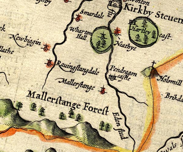 SP14NY70.jpg "Pendragon castle" circle, towers item:- Armitt Library : 2008.14.5 Image © see bottom of page |
|
|
|
||
| evidence:- | table of distances:- Simons 1635 placename:- Pendragon Castle |
|
| source data:- | Table of distances, uncoloured engraving, Westmerland ie
Westmorland, with a thumbnail map, scale about 42 miles to 1
inch, by Mathew Simons, published in A Direction for the English
Traviller, 1635. click to enlarge click to enlargeSIM3.jpg "Pendragon Ca: E" and tabulated distances; P on thumbnail map item:- private collection : 50.39 Image © see bottom of page |
|
|
|
||
| evidence:- | old map:- Jansson 1646 placename:- Pendragon Castle |
|
| source data:- | Map, hand coloured engraving, Cumbria and Westmoria, ie
Cumberland and Westmorland, scale about 3.5 miles to 1 inch, by
John Jansson, Amsterdam, Netherlands, 1646.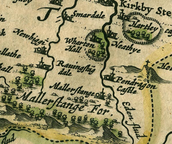 JAN3NY70.jpg "Pendragon Castle" Buildings and tower with flag. item:- JandMN : 88 Image © see bottom of page |
|
|
|
||
| evidence:- | old map:- Sanson 1679 placename:- Pendragon |
|
| source data:- | Map, hand coloured engraving, Ancien Royaume de Northumberland
aujourdhuy Provinces de Nort, ie the Ancient Kingdom of
Northumberland or the Northern Provinces, scale about 9.5 miles
to 1 inch, by Nicholas Sanson, Paris, France, 1679. click to enlarge click to enlargeSAN2Cm.jpg "Pendragon" circle, 2 towers, flag; castle item:- Dove Cottage : 2007.38.15 Image © see bottom of page |
|
|
|
||
| evidence:- | old map:- Seller 1694 (Wmd) placename:- Pendragon Castle |
|
| source data:- | Map, hand coloured engraving, Westmorland, scale about 8 miles
to 1 inch, by John Seller, 1694. click to enlarge click to enlargeSEL7.jpg "Pendragon Cast." circle; castle item:- Dove Cottage : 2007.38.87 Image © see bottom of page |
|
|
|
||
| evidence:- | old map:- Morden 1695 (Wmd) placename:- Pendragon Castle |
|
| source data:- | Map, hand coloured engraving, Westmorland, scale about 2.5 miles to 1 inch, by Robert
Morden, published by Abel Swale, the Unicorn, St Paul's Churchyard, Awnsham, and John
Churchill, the Black Swan, Paternoster Row, London, 1695.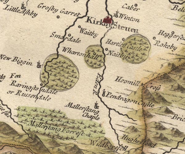 MD10NY70.jpg "Pendragon Castle" Circle, tower with a flag. item:- JandMN : 24 Image © see bottom of page |
|
|
|
||
| evidence:- | descriptive text:- Defoe 1724-26 placename:- Pendragon Castle |
|
| source data:- | Tour through England and Wales, by Daniel Defoe, published in
parts, London, 1724-26. "This lady [Lady Anne Clifford] was one of the family of Clifford; she had no less than four castles in this county, of which Pendragon Castle was the chief, which is a fine building to this day." |
|
|
|
||
| evidence:- | old print:- Buck 1739 placename:- Pendragon Castle item:- Scots; incursion, 1341 |
|
| source data:- | Print, uncoloured engraving, The North West View of Pendragon Castle, in the County
of Westmorland, Mallerstang, Westmorland, drawn and engraved by Samuel and Nathaniel
Buck, published 1739.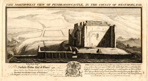 click to enlarge click to enlargeBU0223.jpg printed, top "THE NORTH-WEST VIEW OF PENDRAGON-CASTLE, IN THE COUNTY OF WESTMORLAND." printed, bottom "THIS Castle was entirely destroyed A.D.1341 by ye Scots under their K. David, and is one of those that were repair'd A.D.1660 by the Right Honourable Lady Anne Clifford, Countess Dowager of Pembroke &c. sole Daughter & Heir to ye Right Honble. George, third Earl of Cumberland, three hundred and twenty Years after the Scots had destroy'd it. The present proprietor is the R. Honble. the Earl of Thanet. / Saml. &Nathl. Buck delin: et Sculp: Publish'd according to Act of Parliamt. March 26. 1739." item:- Armitt Library : 1959.67.23 Image © see bottom of page |
|
|
|
||
| evidence:- | descriptive text:- Simpson 1746 placename:- Pendragon Castle |
|
| source data:- | Atlas, three volumes of maps and descriptive text published as
'The Agreeable Historian, or the Compleat English Traveller
...', by Samuel Simpson, 1746. goto source goto sourcePage 1026:- "..." "Pendragon Castle, twelve Miles from Appleby, the Seat of the Earl of Thanet, Hereditary Sheriff of the County." |
|
|
|
||
| evidence:- | old map:- Simpson 1746 map (Wmd) placename:- Pendragon Castle |
|
| source data:- | Map, uncoloured engraving, Westmorland, scale about 8 miles to 1
inch, printed by R Walker, Fleet Lane, London, 1746.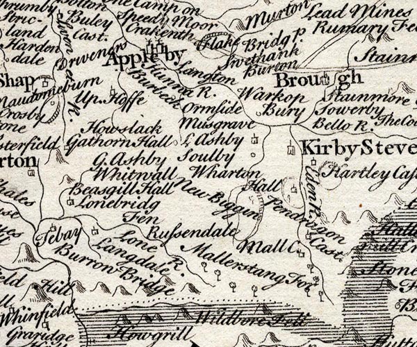 SMP2NYQ.jpg "Pendragon Cast." Building. item:- Dove Cottage : 2007.38.59 Image © see bottom of page |
|
|
|
||
| evidence:- | descriptive text:- Bickham 1753-54 |
|
| source data:- | Maps, A Map of Westmorland, 1753, and A Map of Cumberland, 1754,
by George Bickham, James Street, Bunhill Fields, London;
published 1750s-96. "Noblemen's Seats are Pendragon-Castle, the Earl of Thanet's; ..." |
|
|
|
||
| evidence:- | old text:- Morgan 1759 placename:- Pendragon Castle |
|
| source data:- | MG02q054.txt "of Pendragon-castle, anciently the seat of the Lords Clifford, which, when in its prime, was a strong building, the walls being four yards thick, with battlements upon them. Time, and the neglect of the owners, have brought them to little better than a heap of ruins." |
|
|
|
||
| evidence:- | old map:- Bowen and Kitchin 1760 placename:- Pendragon Castle |
|
| source data:- | Map, hand coloured engraving, A New Map of the Counties of
Cumberland and Westmoreland Divided into their Respective Wards,
scale about 4 miles to 1 inch, by Emanuel Bowen and Thomas
Kitchin et al, published by T Bowles, Robert Sayer, and John
Bowles, London, 1760.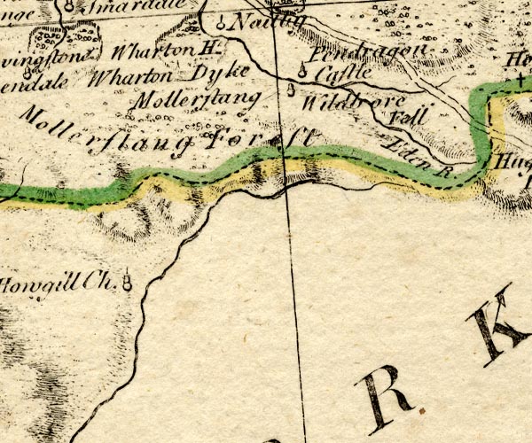 BO18NY70.jpg "Pendragon Castle" circle, tower item:- Armitt Library : 2008.14.10 Image © see bottom of page |
|
|
|
||
| evidence:- | old map:- Jefferys 1770 (Wmd) placename:- Pendragon Castle |
|
| source data:- | Map, 4 sheets, The County of Westmoreland, scale 1 inch to 1
mile, surveyed 1768, and engraved and published by Thomas
Jefferys, London, 1770.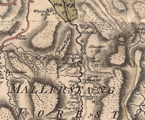 J5NY70SE.jpg "Pendragon Castle" castle item:- National Library of Scotland : EME.s.47 Image © National Library of Scotland |
|
|
|
||
| evidence:- | old text:- Pennant 1773 placename:- Pendragon Castle item:- Arthurian legend; Eden, River; well, Pendragon; poisoned well; library, Pendragon |
|
| source data:- | Book, A Tour from Downing to Alston Moor, 1773, by Thomas
Pennant, published by Edward Harding, 98 Pall Mall, London, 1801. goto source Pennant's Tour 1773, page 131 "About a mile further I reached Pendragon-castle, a small but strong square building, with great marks of age on all its parts. The foundation of this castle is ascribed to the great British hero, Uther Pendragon, the father of the greater Arthur. It is notorious what feats Pendragon ac-" goto sourcePennant's Tour 1773, page 132 "[ac]complished by art-magic, assisted by his friend the sage Merlin. By his aid, he assumed the form of King Gorlois, deceived all his guards, and, during his Majesty's absence on an important seige, got access to the fair Queen Igerna, and passed a rapturous night with the unwitting charmer in the castle of Tintagel. Notwithstanding this, the river Eden baffled all his attempts to make it surround his new fortress - a Queen was an easier conquest." ""Let Uther Pendragon do what he can, "Eden will run where Eden ran."" "It still preserves its old course, and a deep foss on the more defenceless side supplies the place of the obstinate stream. A well near it commemorates another piece of history relative to our Prince: in this it is said the treacherous Saxons, who did not dare to face him in the field, flung poison; he drank of this his favourite spring, and, with a hundred of his courtiers, fell victims to their villainy. I will not insist on this great antiquity of the castle; it possibly may have been British: it is of a square form, of vast thickness, and with rudeness enough for an early period. It certainly is of very long standing, having been, as Anne Clifford informs us in her Diary, the beloved" goto sourcePennant's Tour 1773, page 133 "seat of Idonea, daughter of Robert de Veteripont, a lady who died either in the latter end of Henry III. or beginning of the reign of Edward I. Little of its history is preserved: it was burnt in an inroad of the Scots about the year 1341; was restored and sunk again in that of 1541, it having, as the inscription informs us, lain ruinous from that year to 1600, when it was repaired by the celebrated heroine Anne, who relates in the same inscription that she came to lie in it herself for a little while in October 1661. We are informed in her Diary, that she took up the design as early as the year 1615, for the purpose of making it a library for a Mr. Christopher Wolridge, who probably never lived to the time in which she was able to bring it into execution. The inscription at the conclusion refers to this most apt text: "And they that shall be of thee shall build the old waste places: thou shall raise up the foundations of many generations, and thou shalt be called the repairer of the breach, the restorer of paths to dwell in." Isaiah, ch.lviii. verse 12. - No person ever merited the application so strongly. She restored six of the castles of her ancestors, Brough, Brougham, Appleby, Barden Tower, Skipton, and that in question. To give an easy access to the castle, she built the neighbouring bridge over the Eden, and at a small distance beneath the castle she built stables and other offices, but their place is only marked by the ruins." goto sourcePennant's Tour 1773, page 134 "..." "The view from the castle southward is along a valley terminating with Wild-boar-fell, which impends with a great cape-like head over the country, soaring to a great height, and at its base is the fountain of the river" |
|
|
|
||
| evidence:- | old text:- Camden 1789 placename:- Pendragon Castle |
|
| source data:- | Book, Britannia, or A Chorographical Description of the Flourishing Kingdoms of England,
Scotland, and Ireland, by William Camden, 1586, translated from the 1607 Latin edition
by Richard Gough, published London, 1789. goto source Page 147:- "... Pendragon castle, to which time has left nothing but a name and heap of stones; ..." |
|
|
|
||
| evidence:- | old text:- Camden 1789 (Gough Additions) placename:- Pendragon Castle |
|
| source data:- | Book, Britannia, or A Chorographical Description of the Flourishing Kingdoms of England,
Scotland, and Ireland, by William Camden, 1586, translated from the 1607 Latin edition
by Richard Gough, published London, 1789. Page 156:- "..." "Pendragon castle belonged to the Cliffords from the beginning of Edward II. and now again reduced to bare walls, four yards thick and embattled, was rebuilt 1660 by Ann Clifford countess dowager of Pembroke, Dorset, and Montgomery, with three other antient seats of her ancestors in this county; in which she kept up the antient hospitality by removing from one to the other, and diffused her charity all over the county. Over the entrance of the castle is this inscription:" ""This Pendragon castle was repaired by the lady Anne Clifford, countesse dowager of Pembroke, Dorsett, and Montgomerie, baronesse Clifford, Westmerland, and Vescie, high sheriffesse by inheritance of the county of Westmerland, and lady of the honour of Skepton in Craven in the year 1660; so as she came to lye in it herself for a little while in October 1661, after it had layen ruinus without timber or any covering, ever since the year 1541. Isiah, chap.lviii. ver.12.""God's name be praised."" "... The castle was demolished by Thomas earl of Thanet about 1685. It is washed on the east by the Eden, and on the other side are great trenches, as if its founder meant to draw the water round it. But tradition says the attempt failed; and, according to the old provincial rhyme,Let Pendragon do what he can, Eden will run where Eden ran." |
|
|
|
||
| evidence:- | old map:- Cary 1789 (edn 1805) placename:- Pendragon Castle |
|
| source data:- | Map, uncoloured engraving, Westmoreland, scale about 2.5 miles
to 1 inch, by John Cary, London, 1789; edition 1805.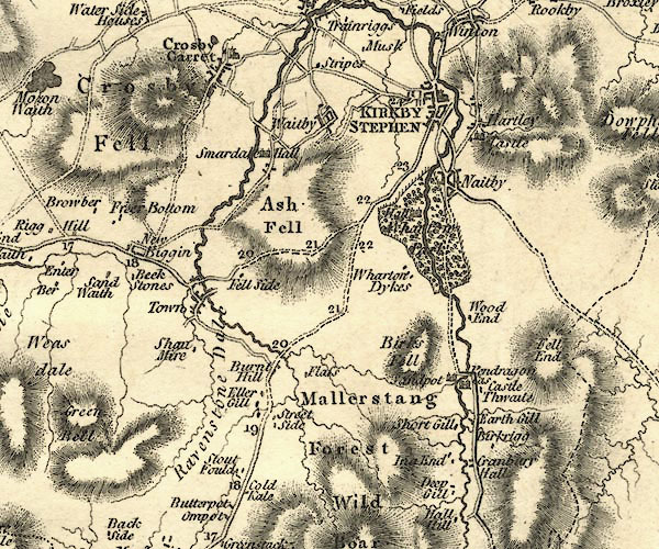 CY24NY70.jpg "Pendragon Cas" house symbol; castle item:- JandMN : 129 Image © see bottom of page |
|
|
|
||
| evidence:- | old map:- Laurie and Whittle 1806 placename:- Pendragon Castle |
|
| source data:- | Road map, Continuation of the Roads to Glasgow and Edinburgh,
scale about 10 miles to 1 inch, by Nathaniel Coltman? 1806,
published by Robert H Laurie, 53 Fleet Street, London, 1834. click to enlarge click to enlargeLw21.jpg "Pendragon Castle 262½" castle; distance from London item:- private collection : 18.21 Image © see bottom of page |
|
|
|
||
| evidence:- | old text:- Capper 1808 placename:- Pendragon Castle |
|
| source data:- | Gazetteer, A Topographical Dictionary of the United Kingdom,
compiled by Benjamin Pitts Capper, published by Richard
Phillips, Bridge Street, Blackfriars, London, 1808; published
1808-29. goto source "... Near the town [Kirkby Stephen] are the ruins of Penpragon (sic) castle, anciently the seat of the Cliffords. It was of amazing strength, the walls being four yards thick, with embattlements; but little remains at present, except a square tower, apparently of more modern date, as it appears to have been repaired by the countess of Pembroke after it had lain in ruins for nearly two centuries. Its situation, as a place of strength, was badly chosen, being in a deep dell entirely overlooked by mountains; on the opposite side of the dell are the traces of an entrenchment and fortification. ..." |
|
|
|
||
| evidence:- | old text:- Gents Mag item:- well; poison |
|
| source data:- | Magazine, The Gentleman's Magazine or Monthly Intelligencer or
Historical Chronicle, published by Edward Cave under the
pseudonym Sylvanus Urban, and by other publishers, London,
monthly from 1731 to 1922. goto source Gentleman's Magazine 1825 part 1 p.516 "Compendium of County History. - Westmorland." "Near PENDRAGON Castle is a well which commemorates a piece of history respecting Uter Pendragon. It is said the treacherous Saxons who dared not face him in the field, flung poison into the well. He drank of this his favourite spring, and with a hundred of his courtiers fell victim to the Saxon villany." |
|
|
|
||
| evidence:- | old photograph:- Bell 1880s-1940s |
|
| source data:- | Photograph, black and white, Pendragon Castle, Mallerstang, Westmorland, by Herbert
Bell, photographer, Ambleside, Westmorland, 1890s.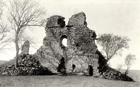 click to enlarge click to enlargeHB0657.jpg item:- Armitt Library : ALPS320 Image © see bottom of page |
|
|
|
||
| evidence:- | old photograph:- Bell 1880s-1940s placename:- Pendragon Castle |
|
| source data:- | Photograph, Pendragon Castle, Mallerstang, Westmorland, by Herbert Bell, photographer,
Ambleside, Westmorland, 1894.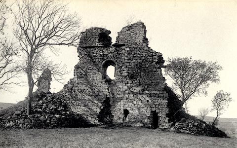 click to enlarge click to enlargeHB0031.jpg Vol.1 no.31 in an album, Examples of Early Domestic and Military Architecture in Westmorland, assembled 1910. ms at bottom:- "31. Pendragon Castle. Kirkby Stephen. E." item:- Armitt Library : 1958.3165.31 Image © see bottom of page |
|
|
|
||
| evidence:- | old photograph:- Bell 1880s-1940s placename:- Pendragon Castle |
|
| source data:- | Photograph, Pendragon Castle, Mallerstang, Westmorland, by Herbert Bell, photographer,
Ambleside, Westmorland, 1897.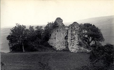 click to enlarge click to enlargeHB0032.jpg Vol.1 no.32 in an album, Examples of Early Domestic and Military Architecture in Westmorland, assembled 1910. ms at bottom:- "32. Pendragon Castle. Kirkby Stephen. E." item:- Armitt Library : 1958.3165.32 Image © see bottom of page |
|
|
|
||
| evidence:- | site plan:- Curwen 1913 placename:- Pendragon Castle |
|
| source data:- | Site plan, lithograph, Pendragon Castle, Plan of Solar, Mallerstang, Westmorland,
scale about 1 to 260, published for the Cumberland and Westmorland Antiquarian and
Archaeological Society by Titus Wilson, Kendal, Westmorland, 1913.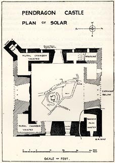 click to enlarge click to enlargeCW0121.jpg On p.120 of The Castles and Fortified Towers of Cumberland, Westmorland, and Lancashire North of the Sands, by John F Curwen. printed at upper right:- "Plan of Carlisle Castle:" item:- Armitt Library : A782.21 Image © see bottom of page |
|
|
|
||
| evidence:- | site plan:- Historical Monuments 1936 placename:- Pendragon Castle |
|
| source data:- | Site plan, uncoloured lithograph, Pendragon Castle Mallerstang, Westmorland, scale
about 1 to 380, published by Royal Commission on Historical Monuments England, London,
1936.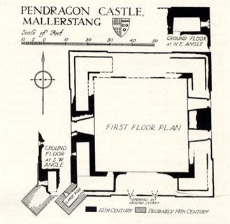 click to enlarge click to enlargeHMW101.jpg On p.163 of the Inventory of the Historical Monuments in Westmorland. printed, upper left "PENDRAGON CASTLE / MALLERSTANG" RCHME no. Wmd, Mallerstang 3 item:- Armitt Library : A745.101 Image © see bottom of page |
|
|
|
||
| evidence:- | text:- Jackson 1990 placename:- Melvestang castle placename:- Castle of Mallerstang placename:- Mallerstang, Castle of |
|
| source data:- | ||
|
|
||
| evidence:- | database:- Listed Buildings 2010 placename:- Pendragon Castle |
|
| source data:- | courtesy of English Heritage "PENDRAGON CASTLE / / B6259 (NORTH OF OUTHGILL) / MALLERSTANG / EDEN / CUMBRIA / I / 73359 / NY7817002626" |
|
| source data:- | courtesy of English Heritage "Fortified tower-house dating from C12 with later additions and alterations; extensively restored 1660 for Lady Anne Clifford. Dismantled c1685. See descrip- tion and plan in R.C.H.M. pp 163-164; since its publication some of the fallen masonry has been cleared away, uncovering north entrance with spiral stair to either side of passage which was closed by portcullis (slot visible in masonry). Scheduled Ancient Monument." |
|
|
|
||
| evidence:- | old print:- Braithwaite 1922 placename:- Pendragon Castle |
|
| source data:- | Print, halftone photograph, Pendragon Castle, Mallerstang, Westmorland, published
by J W Braithwaite and Sons, Kirkby Stephen, Westmorland, 1922.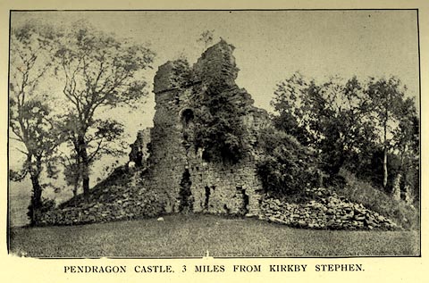 click to enlarge click to enlargeBT0105.jpg Tipped in opposite p.16 of a guide book, Kirkby Stephen, 4th edn 1922. printed at bottom:- "PENDRAGON CASTLE, 3 MILES FROM KIRKBY STEPHEN." item:- private collection : 220.5 Image © see bottom of page |
|
|
|
||
| evidence:- | old print:- Pennant 1773 (edn 1801) placename:- Pendragon Castle |
|
| source data:- | Print, engraving, Pendragon Castle, Mallerstang, Westmorland, drawn by Moses Griffith,
engraved by S Sparrow, published by Edward Harding, 98 Pall Mall, London, 1801.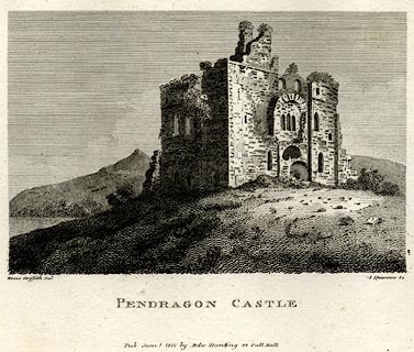 click to enlarge click to enlargePEN618.jpg Tipped in opposite p.131 of A Tour from Downing to Alston Moor, 1773, by Thomas Pennant. printed at bottom left, right, centre:- "Moses Griffith. Del / S Sparrow. Sc / PENDRAGON CASTLE / Pub June 1 1801 by Edw Harding 98 Pall Mall." item:- Armitt Library : A1057.18 Image © see bottom of page |
|
|
|
||
 BJQ82.jpg (taken 24.7.2005) |
||
|
|
||
| hearsay:- |
The castle is said to have been built by Sir Hugh de Morville in the time of Henry
II. Sir Hugh was one of the four murderers of Thomas a Becket, 1170, though tradition
says he only held back the crowd at sword point while the cleric was killed. After
the murder he was exiled to France. Ownership of the castle eventually went to a nephew. |
|
| John gave Mallerstang, including the castle, to Robert de Vetripont, 1202. The Vipont
Family held the castle for 700 years, till it went to the Clifford Family and descendants.
It was one of the favourite seats of Lady Anne Clifford. She repaired the castle in
the mid 17th century, recording that she:- |
||
| "came to lie in it herselfe for a little while in October 1661, after it had layen
ruinous without timber or any covering since the year 1541." |
||
|
|
||
| hearsay:- |
It is said that Uther Pendragon lived here, the father of King Arthur. He built the
original castle on an existing mound, roman of course, in the late 5th century. Uther
was a giant warrior, and a canibal, and fought the Saxons from Dumfries to Cornwall.
Merlin, the magician, is supposed to have helped Uther take the form of King Gorlois
so that he could sleep with the queen, Igerna, at Tintagel Castle. Thus was Arthur
conceived. |
|
| Uther tried to divert the River Eden to flow around the moat at Pendragon castle,
and failed. |
||
| "Let Uther Pendragon do what he can Eden will run where Eden ran." |
||
| Awkward stuff, water. The moat is dry. |
||
| The Saxons could not defeat Uther on the battlefield, but in a siege they poisonned
the water supply. In 515 Uther and a hundred supporters died from the poisonned water
from the castle well. Then there was anarchy, till Arthur grew old enough to create
a kingdom. |
||
|
|
||
| Robertson, Dawn & Koronka, Peter: 1992: Secrets and Legends of Old Westmorland: Pagan
Press (Kirkby Stephen, Cumbria) &Cumbria CC (library service) |
||
|
|
||
| notes:- |
12th century castle restored in the 17th century; in ruins |
|
| Perriam, D R &Robinson, J: 1998: Medieval Fortified Buildings of Cumbria: CWAAS::
ISBN 1 873124 23 6; plan and illustrations |
||
|
|
||
| personal | ||
| person:- | : Arthur, King |
|
| place:- | birthplace | |
|
|
||
Lakes Guides menu.