 Jefferys 1770 SD69SE

|

|
|
|
gazetteer links places may or may not be labelled on the map |
||

|
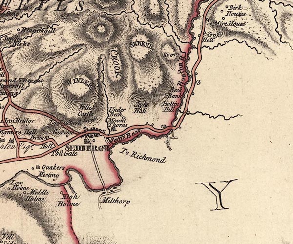
-- Arant Haw |
|
|
|
-- Buckbank -- "Beck Bank" |
|
|
|
-- Burnt Mill |
|
|
|
-- Castlehaw -- "Castle Low" |
|
|
|
-- Clough River |
|
|
|
-- Crook -- "CROOK" |
|
|
|
-- Cross Hall -- "Cross Hall" |
|
|
|
-- Cross Haw Bridge |
|
|
|
-- Crosshaw Beck |
|
|
|
-- Dee, River |
|
|
|
-- Garsdale Bridge |
|
|
|
-- Grimes Gill |
|
|
|
-- Gunrow -- "Gunrow" |
|
|
|
-- Hebblethwaite Hall Gill |
|
|
|
-- High Holme -- "High Holme" |
|
|
|
-- Hobdale Beck |
|
|
|
-- Hollin Hill -- "Hollin Hill" |
|
|
|
-- Knott -- "KNOT" |
|
|
|
-- Lockbank Farm -- "Lock Bank" |
|
|
|
-- Millthrop Bridge |
|
|
|
-- Millthrop -- "Milthorp" |
|
|
|
-- New Bridge |
|
|
|
-- Old House at the Hill, The -- "Hill" |
|
|
|
-- Rawthey, River -- "Roatha R." |
|
|
|
-- Kendal to Sedbergh |
|
|
|
-- Kirkby Lonsdale to Sedbergh -- "F. S to K. 11.2" |
|
|
|
-- Sedbergh to Hawes -- "To Richmond" |
|
|
|
-- Sedbergh to Kirkby Stephen |
|
|
|
-- Sedbergh -- "SEDBERGH" |
|
|
|
-- Settlebeck -- "Settle Beck" |
|
|
|
-- Settlebeck Bridge |
|
|
|
-- Settlebeck Gill |
|
|
|
-- Sickers Fell -- "SERKER" |
|
|
|
-- St Andrew's Church |
|
|
|
-- Stone Hall -- "Stone Hall" |
|
|
|
-- Straight Bridge |
|
|
|
-- Thorns Hall -- "Mount Thorns" |
|
|
|
-- Toll Bar -- "Toll Gate" |
|
|
|
-- Underbank -- "Under Beck" |
|
|
|
-- Whinny Gill |
|
|
|
-- Winder -- "WINDER" |
|
|
civil parishes The area roughly includes parts of parishes:- Sedbergh Dent Garsdale |
||
|
|
||
|
|
Lakes Guides menu. | |