 Jefferys 1770 NY70NE

|

|
|
|
gazetteer links places may or may not be labelled on the map |
||

|
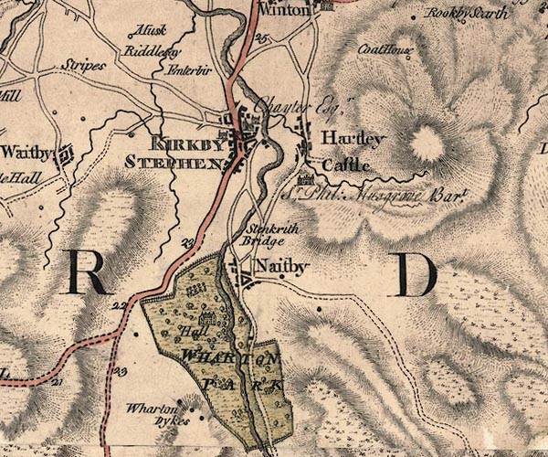
-- Birkett Hill |
|
|
|
-- Bollam Bridge |
|
|
|
-- Cote Garth -- "Coat House" |
|
|
|
-- Eden, River -- "Eden River" -- "Eden
River" -- "Eden R." |
|
|
|
-- Enterber -- "Enterbir" |
|
|
|
-- Hartley Beck |
|
|
|
-- Hartley Castle -- "Hartley Castle / Sr: Phil: Musgrove
Bart." |
|
|
|
-- Hartley |
|
|
|
-- Kirkby Stephen -- "KIRKBY STEPHEN / Chayter
Esqr." |
|
|
|
-- Nateby -- "Naitby" |
|
|
|
-- New Bridge |
|
|
|
-- Riddlesay -- "Riddlesay" |
|
|
|
-- Kirkby Stephen to Brough |
|
|
|
-- Kirkby Stephen to Moorcock -- "to Askrigg" |
|
|
|
-- Kirby Stephen to Richmond -- "To Richmond and
York" |
|
|
|
-- Sedbergh to Kirkby Stephen |
|
|
|
-- Tebay to Kirkby Stephen |
|
|
|
-- Kirkby Stephen to Tan Hill |
|
|
|
-- Soulby road -- "F. O to K 13 4" |
|
|
|
-- Kirkby Stephen to Rey Cross |
|
|
|
-- St Stephen's Church (?) |
|
|
|
-- Stenkrith Bridge -- "Stenkrith Bridge" |
|
|
|
-- Waitby Beck |
|
|
|
-- Wharton Dikes -- "Wharton Dykes" |
|
|
|
-- Wharton Hall -- "WHARTON PARK / Hall" |
|
|
civil parishes The area roughly includes parts of parishes:- Asby Waitby Kirkby Stephen Wharton Nateby Hartley Winton |
||
|
|
||
|
|
Lakes Guides menu. | |