 Old Cumbria Gazetteer
 |
 |
|
|
| road, Kirkby Stephen to Richmond | |||
| Kirby Stephen to Richmond | |||
| Richmond to Kirby Stephen | |||
| B6270 | |||
| civil parish:- | Kirkby Stephen (formerly Westmorland) | ||
| civil parish:- | Nateby (formerly Westmorland) | ||
| county:- | Cumbria | ||
| locality type:- | road route | ||
| 10Km square:- | NY70 | ||
| 10Km square:- | NY80 | ||
| county:- | North Yorkshire | ||
| 10Km square:- | NY80 | ||
| 10Km square:- | SD89 | ||
| 10Km square:- | SD99 | ||
| 10Km square:- | SE09 | ||
| 10Km square:- | SE19 | ||
| 10Km square:- | NZ10 | ||
|
|
|||
| evidence:- | old map:- Jefferys 1770 (Wmd) |
||
| source data:- | Map, 4 sheets, The County of Westmoreland, scale 1 inch to 1
mile, surveyed 1768, and engraved and published by Thomas
Jefferys, London, 1770.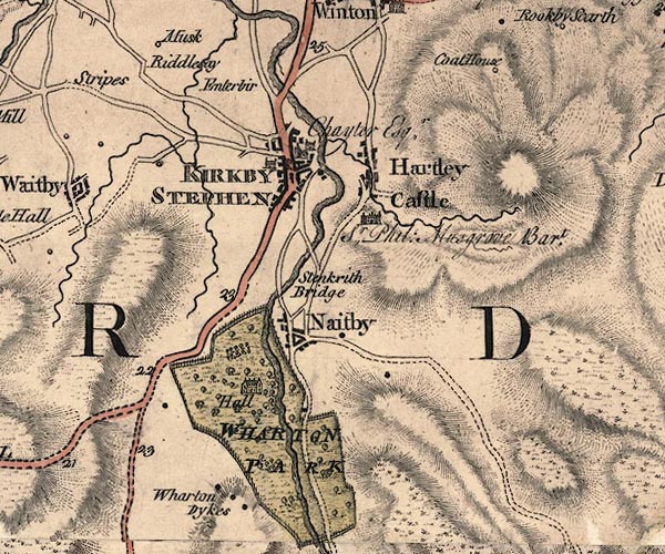 J5NY70NE.jpg 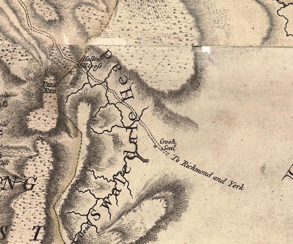 J5NY80SW.jpg "To Richmond and York" double line; road item:- National Library of Scotland : EME.s.47 Images © National Library of Scotland |
||
|
|
|||
| evidence:- | old map:- Cary 1789 (edn 1805) |
||
| source data:- | Map, uncoloured engraving, Westmoreland, scale about 2.5 miles
to 1 inch, by John Cary, London, 1789; edition 1805. CY24NY70.jpg  CY24NY80.jpg double line, bold light, numbered miles; main road item:- JandMN : 129 Image © see bottom of page |
||
|
|
|||
| evidence:- | road map:- Cary 1790 (Wmd/edn 1792) |
||
| source data:- | Road map, hand coloured engraving, Westmoreland, scale about
11.5 miles to 1 inch, by John Cary, 181 Strand, London, 1790,
edn 1792.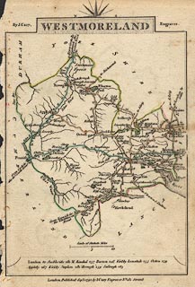 click to enlarge click to enlargeCY16.jpg "to Richmond" double line item:- JandMN : 44 Image © see bottom of page |
||
|
|
|||
| evidence:- | old map:- Cooke 1802 |
||
| source data:- | Map, Westmoreland ie Westmorland, scale about 12 miles to 1
inch, by George Cooke, 1802, published by Sherwood, Jones and
Co, Paternoster Road, London, 1824. click to enlarge click to enlargeGRA1Wd.jpg "to Richmond" double line, light dark dotted; unfenced road item:- Hampshire Museums : FA2000.62.4 Image © see bottom of page |
||
|
|
|||
| evidence:- | old map:- Laurie and Whittle 1806 |
||
| source data:- | Road map, Continuation of the Roads to Glasgow and Edinburgh,
scale about 10 miles to 1 inch, by Nathaniel Coltman? 1806,
published by Robert H Laurie, 53 Fleet Street, London, 1834. click to enlarge click to enlargeLw21.jpg light line; 'Other Direct Roads from LONDON'; and dotted line with plus signs; 'Indifferent Cross Roads' item:- private collection : 18.21 Image © see bottom of page |
||
|
|
|||
| evidence:- | old map:- Cooper 1808 |
||
| source data:- | Map, hand coloured engraving, Westmoreland ie Westmorland, scale
about 9 miles to 1 inch, by H Cooper, 1808, published by R
Phillips, Bridge Street, Blackfriars, London, 1808. click to enlarge click to enlargeCOP4.jpg double line; road item:- Dove Cottage : 2007.38.53 Image © see bottom of page |
||
|
|
|||
| evidence:- | old map:- Wallis 1810 (Wmd) |
||
| source data:- | Road map, Westmoreland, scale about 19 miles to 1 inch, by James
Wallis, 77 Berwick Street, Soho, 1810, published by W Lewis,
Finch Lane, London, 1835? click to enlarge click to enlargeWAL5.jpg "to Richmond" double line, light bold; 'Turnpike Road' item:- JandMN : 63 Image © see bottom of page |
||
|
|
|||
| evidence:- | gradient diagram:- Gall and Inglis 1890s-1900s (Roads) |
||
| source data:- | Contour Road Book of England, Northern Division, by Harry R G Inglis, published by
Gall and Inglis, 25 Paternoster Square, London and Edinburgh, 1898.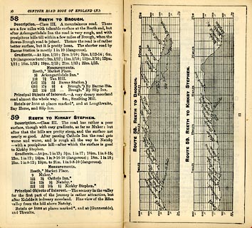 click to enlarge click to enlargeIG5058.jpg Itinerary, with gradient diagram, route 58, Reeth to Brough and route 59, Reeth to Kirkby Stephen, Yorkshire and Cumberland, 1898. item:- JandMN : 763.6 Image © see bottom of page |
||
|
|
|||
| place:- |  Kirkby Stephen Nateby Keld, North Yorkshire Reeth, North Yorkshire Richmond, North Yorkshire Kirkby Stephen Nateby Keld, North Yorkshire Reeth, North Yorkshire Richmond, North Yorkshire |
||
|
|
|||
Lakes Guides menu.