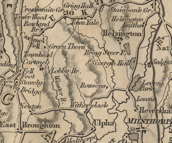
 Ford 1839 map SD48


|

|
|
|
gazetteer links places may or may not be labelled on the map |
||

|
-- Bowland Bridge -- "Bowland Br" |
|
|
|
-- Brigsteer Park -- "Brigg Steer P." |
|
|
|
-- Cartmel Fell -- "Cartmel" |
|
|
|
-- Green Thorn -- "Green Thorn" |
|
|
|
-- Helsington Laithes -- "Helsington" --
"Helsington Laithes" |
|
|
|
-- Heversham -- "Heversham" |
|
|
|
-- High Newton -- "Newton" |
|
|
|
-- Levens Park -- "Levens Park" |
|
|
|
-- Levens -- "Levens" |
|
|
|
-- Lobby Bridge -- "Lobby Br." |
|
|
|
-- Milnthorpe -- "MILNTHORPE" |
|
|
|
-- Rawsons -- "Rowsons" |
|
|
|
-- Kendal to Newby Bridge -- "U to K 21 Ms." |
|
|
|
-- Sizergh Castle -- "Sizergh Hall" |
|
|
|
-- Town Yeat -- "Town Yale" |
|
|
|
-- Ulpha -- "Ulpha" |
|
|
|
-- Winster, River -- "Winster R." |
|
|
|
-- Witherslack -- "Witherslack" |
|
|
civil parishes The area roughly includes parts of parishes:- Broughton East Staveley-in-Cartmel Underbarrow and Bradleyfield Heversham Witherslack Beetham Meathop and Ulpha Milnthorpe Cartmel Fell Crosthwaite and Lyth Levens Helsington Upper Allithwaite Grange-over-Sands |
||
|
|
||
|
|
Lakes Guides menu. | |