 Ford 1839 map SD29


|

|
|
|
gazetteer links places may or may not be labelled on the map |
||

|
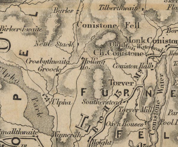
-- Coniston Fells -- "Conistone Fell" |
|
|
|
-- Crook, The -- "Crosbythwaite Crook" |
|
|
|
-- Furness Fells -- "FURNESS FELLS" |
|
|
|
-- Hollin House -- "Holling Ho." |
|
|
|
-- Nettle Slack -- "Nettle Stack" |
|
|
|
-- Old Man of Coniston, The -- "Old Man" |
|
|
|
-- Oxen House -- "Oxen Houses" |
|
|
|
-- Hawkshead to Broughton -- "B to H 13 Ms." |
|
|
|
-- Souterstead -- "Southerstead" |
|
|
|
-- Torver Mill -- "Torver Mill" |
|
|
|
-- Torver -- "Torver" |
|
|
|
-- Ulpha Park -- "Ulpha Park" |
|
|
|
-- Ulpha -- "Ulpha" |
|
|
civil parishes The area roughly includes parts of parishes:- Blawith and Subberthwaite Torver Coniston Kirkby Ireleth Dunnerdale-with-Seathwaite Ulpha Colton Broughton West Eskdale |
||
|
|
||
|
|
Lakes Guides menu. | |