 Old Cumbria Gazetteer
 |
 |
|
| Coniston Fells, Coniston | ||
| Coniston Fells | ||
| civil parish:- | Coniston (formerly Lancashire) | |
| county:- | Cumbria | |
| locality type:- | hill | |
| locality type:- | fell | |
| coordinates:- | SD28249863 (etc) | |
| 1Km square:- | SD2898 | |
| 10Km square:- | SD29 | |
|
|
||
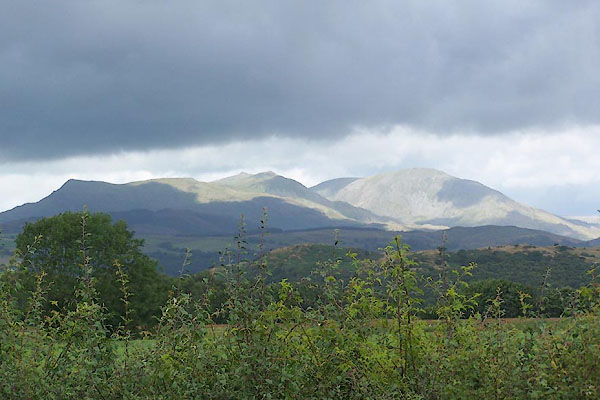 BJR46.jpg From the south. (taken 5.8.2005) 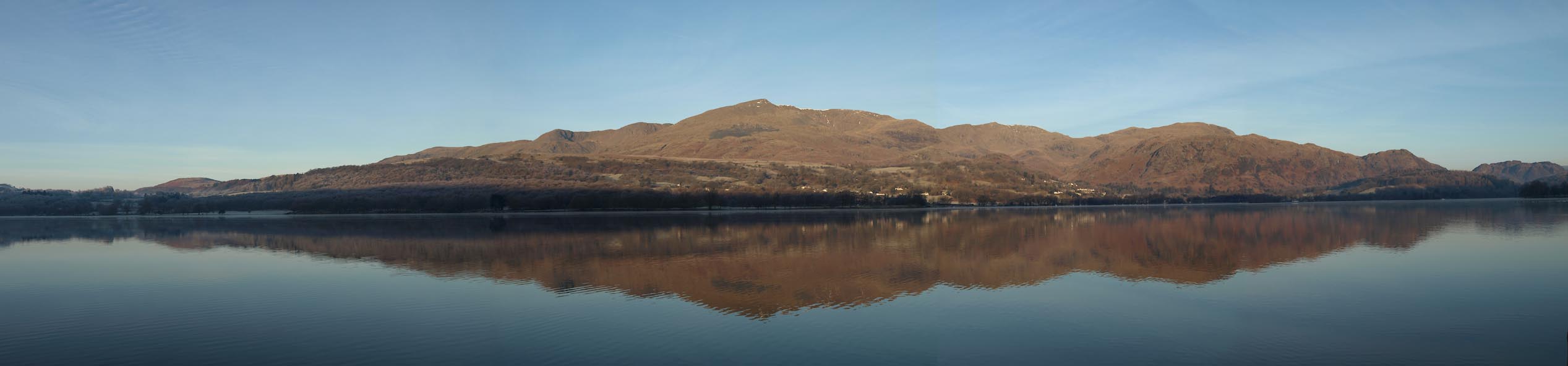 Click to enlarge BTX55.jpg From Brantwood. (taken 21.1.2011) |
||
|
|
||
| evidence:- | old map:- Simpson 1746 map (Wmd) placename:- Fourness Fells |
|
| source data:- | Map, uncoloured engraving, Westmorland, scale about 8 miles to 1
inch, printed by R Walker, Fleet Lane, London, 1746.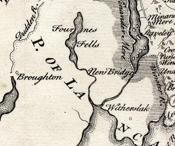 SMP2SDJ.jpg "Fourness Fells" Area. item:- Dove Cottage : 2007.38.59 Image © see bottom of page |
|
|
|
||
| evidence:- | old map:- West 1784 map placename:- Coniston Fells |
|
| source data:- | Map, hand coloured engraving, A Map of the Lakes in Cumberland,
Westmorland and Lancashire, scale about 3.5 miles to 1 inch,
engraved by Paas, 53 Holborn, London, about 1784.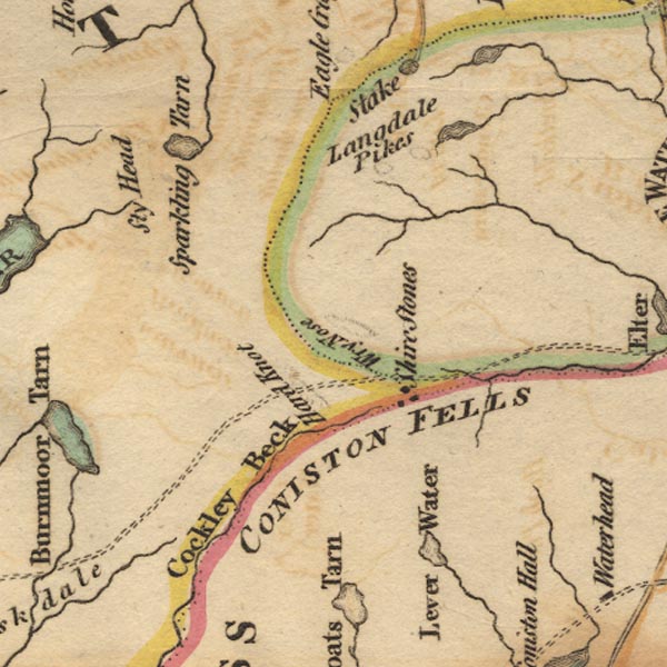 Ws02NY20.jpg "CONISTON FELLS" item:- Armitt Library : A1221.1 Image © see bottom of page |
|
|
|
||
| evidence:- | outline view:- Otley 1823 (4th edn 1830) placename:- Coniston Fell |
|
| source data:- | Print, engraving, outline view, Some of the Western Mountains as seen from Helvellyn,
published by Jonathan Otley, Keswick, Cumberland et al, 1830.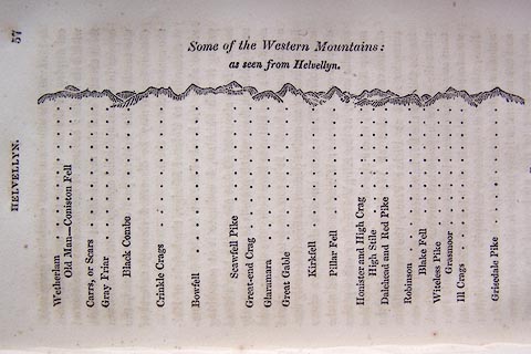 click to enlarge click to enlargeO75E02.jpg p.57 in A Concise Description of the English Lakes, by Jonathan Otley, 4th edition, 1830. "Some of the Western Mountains: / as seen from Helvellyn." "Wetherlam / Old Man - Coniston Fell / Carrs, or Scars / Gray Friar / Black Combe / Crinkle Crags / Bowfell / Scawfell Pike / Great-end Crag / Glaramara / Great Gable / Kirkfell / Pillar Fell / Honister and High Crag / High Stile / Dalehead and Red Pike / Robinson / Blake Fell / Witeless Pike / Grasmoor / Ill Crags / Grisedale Pike" item:- Armitt Library : A1175.3 Image © see bottom of page |
|
|
|
||
| evidence:- | outline view:- Otley 1823 (4th edn 1830) placename:- Coniston Fell |
|
| source data:- | Print, engraving, outline view, Mountains of Coniston, Langdale, &c. as they appear
from the road between Troutbeck Bridge and Bowness, published by Jonathan Otley, Keswick,
Cumberland et al, 1830.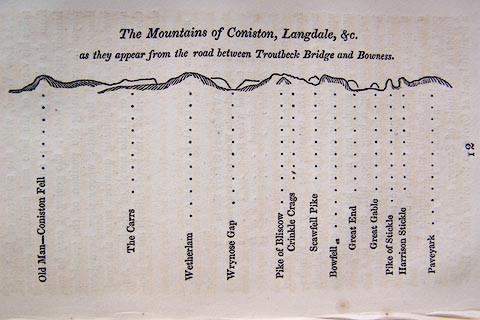 click to enlarge click to enlargeO75E04.jpg p.97 in A Concise Description of the English Lakes, by Jonathan Otley, 4th edition, 1830. "The Mountains of Coniston, Langdale, &c. / as they appear from the road between Troutbeck Bridge and Bowness." "Old Man - Coniston Fell / The Carrs / Wetherlam / Wrynose Gap / Pike of Bliscow / Crinkle Crags / Scawfell Pike / Bowfell / Great End / Great Gable / Pike of Stickle / Harrison Stickle / Paveyark" item:- Armitt Library : A1175.4 Image © see bottom of page |
|
|
|
||
| evidence:- | outline view:- Otley 1823 (8th edn 1849) placename:- Coniston Fell |
|
| source data:- | Engraving, outline view of mountains, Windermere looking towards the West from the
Road between Troutbeck and Bowness, drawn by T Binns, engraved by O Jewitt, opposite
p.4 of A Descriptive Guide of the English Lakes, by Jonathan Otley, 8th edition, 1849.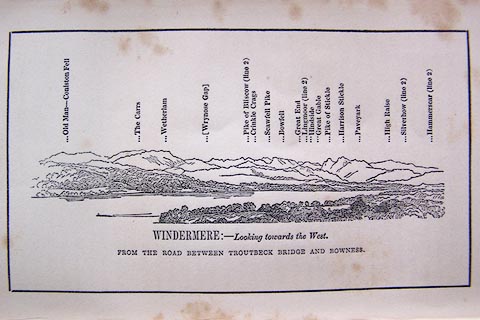 click to enlarge click to enlargeO80E03.jpg item:- Armitt Library : A1180.4 Image © see bottom of page |
|
|
|
||
| evidence:- | outline view:- Otley 1823 (5th edn 1834) placename:- Old Man |
|
| source data:- | Print, woodcut outline view, The Mountains of Coniston, Langdale, Etc, by Jonathan
Otley, Keswick, Cumberland, 1830.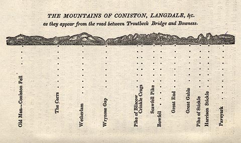 click to enlarge click to enlargeOT2E01.jpg Printed on p.7 of A Concise Description of the English Lakes, by Jonathan Otley, 5th edition, 1834. "THE MOUNTAINS OF CONISTON, LANGDALE, &c. as they appear from the road between Troutbeck Bridge and Bowness." Mountains in the view are listed:- "Old Man - Coniston Fell / The Carrs / Wetherlam / Wrynose Gap / Pike of Bliscow / Crinkle Crags / Scawfell Pike / Bowfell / Great End / Great Gable / Pike of Stickle / Harrison Stickle / Paveyark" item:- JandMN : 48.2 Image © see bottom of page |
|
|
|
||
| evidence:- | descriptive text:- Otley 1823 (5th edn 1834) item:- geology; roof slate; slate quarry |
|
| source data:- | Guide book, A Concise Description of the English Lakes, the
mountains in their vicinity, and the roads by which they may be
visited, with remarks on the mineralogy and geology of the
district, by Jonathan Otley, published by the author, Keswick,
Cumberland now Cumbria, by J Richardson, London, and by Arthur
Foster, Kirkby Lonsdale, Cumbria, 1823; published 1823-49,
latterly as the Descriptive Guide to the English Lakes. goto source goto sourcePage 72:- "CONISTON FELL." "The highest point of Coniston Fell is called THE OLD MAN, from the pile of stones erected on the summit. ... Two tarns appear upon the mountain, the smaller called Low Water, though on a higher level, the larger Levers Water; and on the western side of the hill, but not seen from the summit, is Gates Water, lying at the foot of" goto sourcePage 73:- "the precipitous Dow Crag. ..." "Beginning to ascend at the Black Bull near Coniston Church, you meet on your left a stream abounding in pretty waterfalls; the copper mines near Levers Water, and slate quarries between Low Water and the summit, can be seen by the way; and the descent may be made at choice more in front of the mountain. Those who admire a lengthened mountain excursion, may begin the ascent at Fellfoot, in Little Langdale, and surmounting the Carrs and the Old Man, descend to Coniston." "The summit of the hill, as well as the quarries on its sides, is of a fine, pale blue, roofing slate. A considerable portion of the mountain is formed of a very hard rock, which some have denominated Petro-silex; and between this and Coniston Church, on the western side of the stream, the commencement of the darker coloured slate may be observed." |
|
|
|
||
| evidence:- | old map:- Ford 1839 map placename:- Conistone Fell |
|
| source data:- | Map, uncoloured engraving, Map of the Lake District of
Cumberland, Westmoreland and Lancashire, scale about 3.5 miles
to 1 inch, published by Charles Thurnam, Carlisle, and by R
Groombridge, 5 Paternoster Row, London, 3rd edn 1843.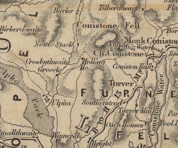 FD02SD29.jpg "Conistone Fell" Hill hachuring. item:- JandMN : 100.1 Image © see bottom of page |
|
|
|
||
| evidence:- | old drawing:- |
|
| source data:- | Drawing, At Coniston, Cumberland, by John Harper, 1840.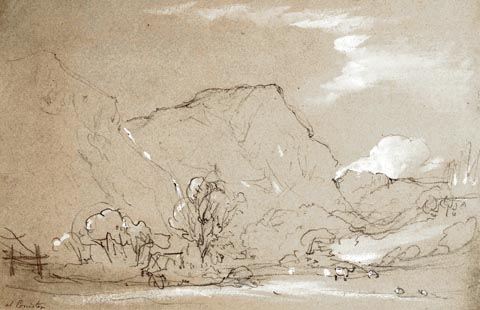 click to enlarge click to enlargePR1388.jpg View of Coniston Fells from the village with field, trees and sheep in the foreground. Executed in pencil with touches of white gouache on buff coloured paper. Preparatory sketch drawn on the spot by the artist. at bottom left:- "at Coniston" item:- Tullie House Museum : 2009.89.32 Image © Tullie House Museum |
|
|
|
||
| evidence:- | outline view:- Tattersall 1836 (version 1869) placename:- Coniston Fells |
|
| source data:- | Print, hand coloured, Coniston Lake, from Waterhead, Coniston, Cumberland, drawn by
George Tattersall, 1836, engraved by W F Topham, published by T J Allman, 463 Oxford
Street, London, 1869.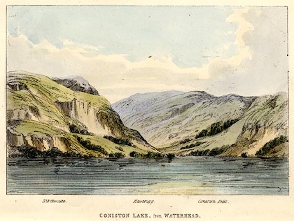 click to enlarge click to enlargeTAT202.jpg Included in The Lakes of England, by W F Topham. printed at bottom:- "CONISTON LAKE, from WATERHEAD" printed at bottom:- "Nibthwaite. / Haverigg. / Coniston Fells." item:- Armitt Library : A1067.2 Image © see bottom of page |
|
|
|
||
| evidence:- | outline view:- Tattersall 1836 placename:- Coniston Fells |
|
| source data:- | Print, engraving, Coniston Lake, from Waterhead, Cumberland, drawn by George Tattersall,
engraved by W F Topham, published by Sherwood and Co, Paternoster Row, London, about
1836.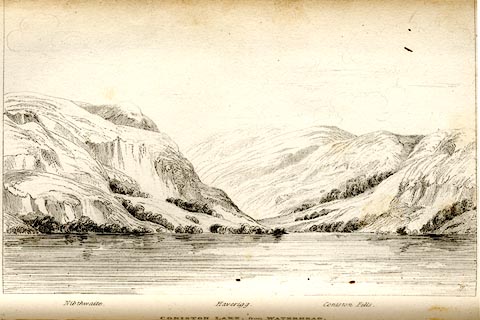 click to enlarge click to enlargeTAT105.jpg The print is captioned with mountain names and acts as an outline view. Tipped in opposite p.35 of The Lakes of England, by George Tattersall. printed at bottom:- "CONISTON LAKE, from WATERHEAD." printed at bottom left to right:- "Nibthwaite. / Haverigg. / Coniston Fells." item:- Armitt Library : A1204.6 Image © see bottom of page |
|
|
|
||
Lakes Guides menu.