 Ford 1839 map SD28


|

|
|
|
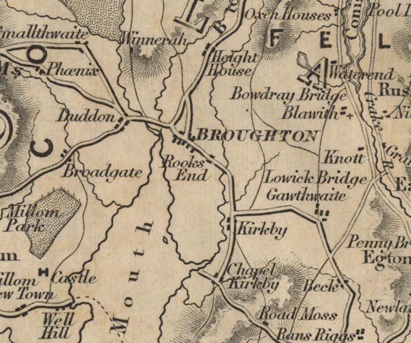
gazetteer links places may or may not be labelled on the map |
||

|
-- Beacon Tarn |
|
|
|
-- Beck Side -- "Chapel Kirkby" |
|
|
|
-- Blawith -- "Blawith" |
|
|
|
-- Bouthrey Bridge -- "Bowdray Bridge" |
|
|
|
-- Broughton Beck -- "Beck" |
|
|
|
-- Broughton in Furness -- "BROUGHTON" |
|
|
|
-- Duddon Bridge -- "Duddon" |
|
|
|
-- Duddon Estuary -- "Duddon Mouth" |
|
|
|
-- Gawthwaite -- "Gawthwaite" |
|
|
|
-- Height House, Broughton West -- "Height House" |
|
|
|
-- High Water End -- "Waterend" |
|
|
|
-- High Whineray Ground -- "Winnerah" |
|
|
|
-- Kirkby-in-Furness -- "Kirkby" |
|
|
|
-- Levers Water |
|
|
|
-- Low Water End -- "Waterend" |
|
|
|
-- Low Whineray Ground -- "Winnerah" |
|
|
|
-- Broughton to Ravenglass -- "R to B 11 Ms." |
|
|
|
-- Hawkshead to Broughton -- "B to H 13 Ms." |
|
|
|
-- Smallthwaite -- "Smallthwaite" |
|
|
|
-- Wreaks End -- "Rooks End" |
|
|
civil parishes The area roughly includes parts of parishes:- Blawith and Subberthwaite Kirkby Ireleth Mansriggs Osmotherley Pennington Colton Egton with Newland Dunnerdale-with-Seathwaite Millom Without Lowick Broughton West Angerton |
||
|
|
||
|
|
Lakes Guides menu. | |