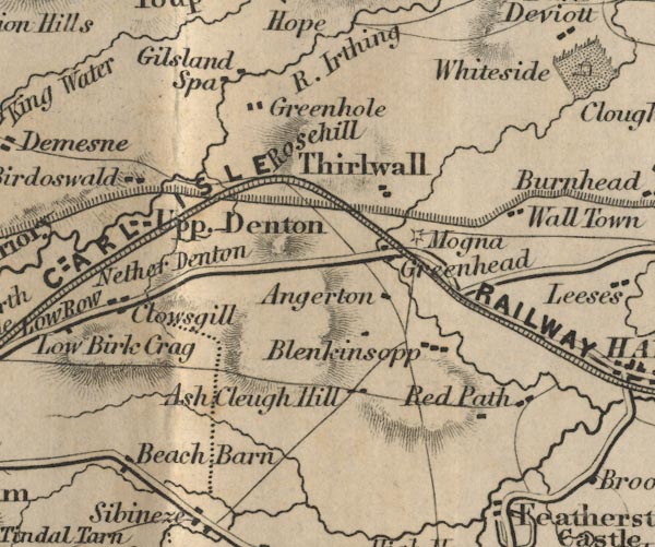
 Ford 1839 map NY66


|

|
|
|
gazetteer links places may or may not be labelled on the map |
||

|
-- Ash Cleugh -- "Ash Cleugh Hill" |
|
|
|
-- Birdoswald -- "Birdoswald" |
|
|
|
-- Blenkinsopp Castle -- "Blenkinsopp" |
|
|
|
-- Closegill -- "Clowsgill" |
|
|
|
-- Gilsland Spa -- "Gilsland Spa" |
|
|
|
-- Greenhead -- "Greenhead" |
|
|
|
-- Greenhole -- "Greenhole" |
|
|
|
-- Hadrian's Wall |
|
|
|
-- Irthing, River -- "R. Irthing" |
|
|
|
-- Nether Denton -- "Nether Denton" |
|
|
|
-- New Angerton -- "Angerton" |
|
|
|
-- Newcastle and Carlisle Railway-- Newcastle and Carlisle
Railway-- Newcastle and Carlisle Railway-- Newcastle and Carlisle
Railway-- Newcastle and Carlisle Railway -- "NEWCASTLE AND
CARLISLE RAILWAY" |
|
|
|
-- Redpeth Farm -- "Red Path" |
|
|
|
-- Roachburn -- "Beach Barn" |
|
|
|
-- Haltwhistle to Brampton |
|
|
|
-- Magnis Roman Fort -- "Mogna" |
|
|
|
-- Rose Hill -- "Rosehill" |
|
|
|
-- Thirlwall -- "Thirlwall" |
|
|
|
-- Upper Denton -- "Upp. Denton" |
|
|
|
-- Walltown -- "Wall Town" |
|
|
civil parishes The area roughly includes parts of parishes:- Kingwater Midgeholme Nether Denton Waterhead Farlam Upper Denton |
||
|
|
||
|
|
Lakes Guides menu. | |