 Ford 1839 map NY42


|

|
|
|
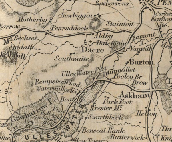
gazetteer links places may or may not be labelled on the map |
||

|
-- Aira Bridge -- "Airy Br" |
|
|
|
-- Aldby -- "Aldby" |
|
|
|
-- Barton -- "Barton" |
|
|
|
-- boat house, Martindale -- "Boat Ho." |
|
|
|
-- Cross Dormont -- "Trester Mt." |
|
|
|
-- Dacre -- "Dacre" |
|
|
|
-- Dalemain -- "Dalemain" |
|
|
|
-- Dunmallard Hill -- "Dunmallet" |
|
|
|
-- Eamont, River -- "Eamont R." |
|
|
|
-- Gowbarrow Hall -- "Gowbarrow Hall" |
|
|
|
-- Gowbarrow Park -- "Gowbarrow Park" |
|
|
|
-- Hallsteads -- "Hallstead" |
|
|
|
-- High Brow -- "Brow" |
|
|
|
-- Knotts -- "Knot" |
|
|
|
-- Low Brow -- "Brow" |
|
|
|
-- Motherby -- "Motherby" |
|
|
|
-- Newbiggin -- "Newbiggin" |
|
|
|
-- Park Foot -- "Park Foot" |
|
|
|
-- Penruddock -- "Penruddock" |
|
|
|
-- Pooley Bridge -- "Pooley Bridge" |
|
|
|
-- Rampsbeck -- "Rampsbeck Lod." |
|
|
|
-- Patterdale to Penrith |
|
|
|
-- Penrith to Keswick -- "K to P 18 Ms." |
|
|
|
-- Southwaite -- "Southwaite" |
|
|
|
-- Stainton -- "Stainton" |
|
|
|
-- Stoddah Farm -- "Stoddah" |
|
|
|
-- Swarthbeck -- "Swarthbeck" |
|
|
|
-- Ullswater -- "ULLES WATER"-- Ullswater-- Ullswater
-- "ULLES WATER"-- Ullswater -- "ULLES
WATER" |
|
|
|
-- Waterfoot -- "Ulles Water Foot" |
|
|
|
-- Watermillock -- "Watermillock" |
|
|
|
-- Yanwath -- "Yanwath" |
|
|
civil parishes The area roughly includes parts of parishes:- Sockbridge and Tirril Penrith Martindale Bampton Barton Askham Catterlen Mungrisdale Greystoke Hutton Dacre Matterdale |
||
|
|
||
|
|
Lakes Guides menu. | |