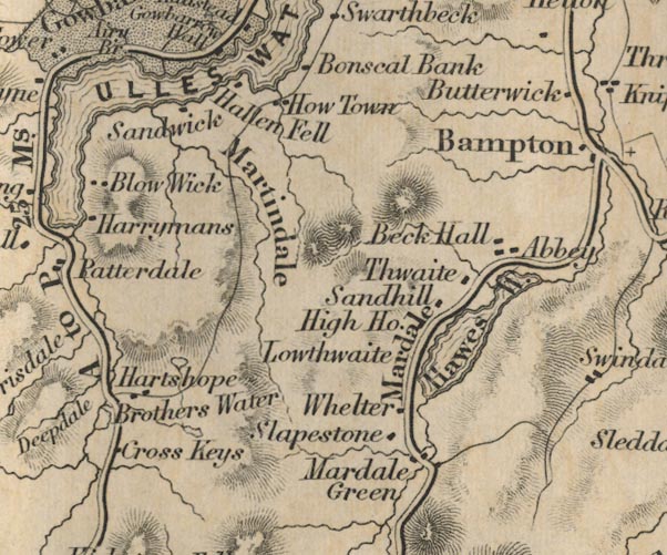
 Ford 1839 map NY41


|

|
|
|
gazetteer links places may or may not be labelled on the map |
||

|
-- Angle Tarn |
|
|
|
-- Beck Hall -- "Beck Hall" |
|
|
|
-- Bonscale -- "Bonscal Bank" |
|
|
|
-- Brothers Water Hotel -- "Cross Keys" |
|
|
|
-- Hallin Fell -- "Hallen Fell" |
|
|
|
-- Hartsop -- "Hartshope" |
|
|
|
-- Hawes Water -- "Hawes W." |
|
|
|
-- Hayeswater |
|
|
|
-- High House -- "High Ho." |
|
|
|
-- Howtown -- "How Town" |
|
|
|
-- Lawthwaite -- "Lowthwaite" |
|
|
|
-- Martindale -- "Martindale" |
|
|
|
-- Mardale to Bampton |
|
|
|
-- Sandhill -- "Sandhill" |
|
|
|
-- Sandwick -- "Sandwick" |
|
|
|
-- Slapestone -- "Slapestone" |
|
|
|
-- Thwaite -- "Thwaite" |
|
|
|
-- Gatescarth to Mardale |
|
|
|
-- Ullswater -- "ULLES WATER"-- Ullswater-- Ullswater
-- "ULLES WATER"-- Ullswater -- "ULLES
WATER" |
|
|
|
-- Whelter -- "Whelter" |
|
|
civil parishes The area roughly includes parts of parishes:- Kentmere Shap Rural Longsleddale Patterdale Martindale Lakes Bampton Barton Matterdale |
||
|
|
||
|
|
Lakes Guides menu. | |