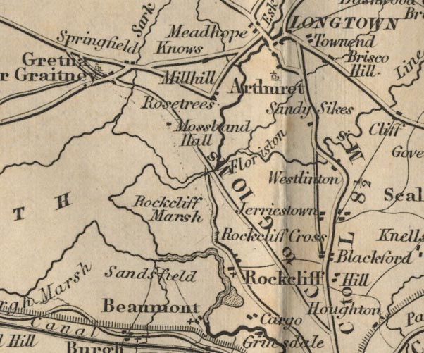
 Ford 1839 map NY36


|

|
|
|
gazetteer links places may or may not be labelled on the map |
||

|
-- Arthuret -- "Arthuret" |
|
|
|
-- Beaumont -- "Beaumont" |
|
|
|
-- Blackford -- "Blackford" |
|
|
|
-- Briscohill -- "Brisco Hill" |
|
|
|
-- Cargo -- "Cargo" |
|
|
|
-- Floristonrigg -- "Floriston" |
|
|
|
-- Gretna -- "Gretna or Graitney" |
|
|
|
-- Hill, The -- "Hill" |
|
|
|
-- Jerriestown -- "Jerriestown" |
|
|
|
-- Knows -- "Knows" |
|
|
|
-- Longtown -- "Longtown" |
|
|
|
-- Mill Hill -- "Millhill" |
|
|
|
-- Mossbandhall -- "Mossband Hall" |
|
|
|
-- Old Sandsfield -- "Sandsfield" |
|
|
|
-- park, Kingmoor |
|
|
|
-- Carlisle to Gretna -- "C to G 10 Ms." |
|
|
|
-- Carlisle to Jedburgh |
|
|
|
-- Carlisle to Langholm -- "C to L 8 1/2 Ms." |
|
|
|
-- Rockcliffe Cross -- "Rockcliff Cross" |
|
|
|
-- Rockcliffe Marsh -- "Rockcliff Marsh" |
|
|
|
-- Rockcliffe -- "Rockcliff" |
|
|
|
-- Rosetrees -- "Rosetrees" |
|
|
|
-- Sandysike -- "Sandy Sikes" |
|
|
|
-- Springfield -- "Springfield" |
|
|
|
-- Townend -- "Townend" |
|
|
|
-- Westlinton -- "Westlinton" |
|
|
civil parishes The area roughly includes parts of parishes:- Beaumont Rockcliffe Kirkandrews Westlinton Arthuret Stanwix Rural Burgh by Sands Kingmoor |
||
|
|
||
|
|
Lakes Guides menu. | |