 Ford 1839 map NY32


|

|
|
|
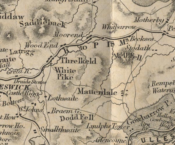
gazetteer links places may or may not be labelled on the map |
||

|
-- Beckces -- "Beckses" |
|
|
|
-- Bram Cragg -- "Braem G." |
|
|
|
-- Great Dodd -- "Dodd Fell" |
|
|
|
-- Great Mell Fell -- "Mell Fell" |
|
|
|
-- Hutton Moor End -- "Moorend" |
|
|
|
-- Lowthwaite -- "Lothwaite" |
|
|
|
-- Lyulph's Tower -- "Lyulph's Tower" |
|
|
|
-- Matterdale -- "Matterdale" |
|
|
|
-- Penrith to Keswick -- "K to P 18 Ms." |
|
|
|
-- Saddleback -- "Saddleback" |
|
|
|
-- Smaithwaite -- "Smallthwaite" |
|
|
|
-- St John's Church -- "St. John's" |
|
|
|
-- Threlkeld -- "Threlkeld" |
|
|
|
-- Whitbarrow -- "Whitbarrow" |
|
|
|
-- White Pike -- "White Pike" |
|
|
|
-- Wood End -- "Wood End" |
|
|
civil parishes The area roughly includes parts of parishes:- St John's Castlerigg and Wythburn Matterdale Hutton Mungrisdale Threlkeld |
||
|
|
||
|
|
Lakes Guides menu. | |