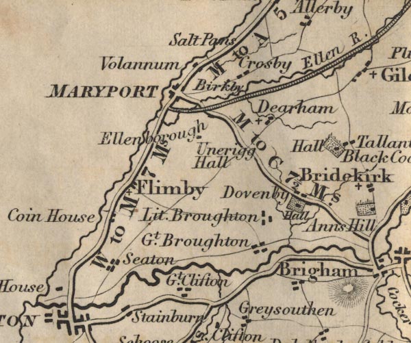
 Ford 1839 map NY03


|

|
|
|
gazetteer links places may or may not be labelled on the map |
||

|
-- Birkby -- "Birkby" |
|
|
|
-- Brigham -- "Brigham" |
|
|
|
-- Coin House -- "Coin House" |
|
|
|
-- Crosby -- "Crosby" |
|
|
|
-- Dearham -- "Dearham" |
|
|
|
-- Dovenby Hall -- "Hall" |
|
|
|
-- Dovenby -- "Dovenby" |
|
|
|
-- Ellen, River -- "Ellen R." |
|
|
|
-- Ellenborough -- "Ellenborough" |
|
|
|
-- Ewanrigg Hall -- "Unerigg Hall" |
|
|
|
-- Flimby -- "Flimby" |
|
|
|
-- Great Broughton -- "Gt. Broughton" |
|
|
|
-- Great Clifton -- "Gt. Clifton" |
|
|
|
-- Little Broughton -- "Lit. Broughton" |
|
|
|
-- Maryport and Carlisle Railway -- "MARYPORT AND CARLISLE
RAILWAY" |
|
|
|
-- Maryport -- "MARYPORT" |
|
|
|
-- Cockermouth to Maryport -- "M to C 7 1/2 Ms." |
|
|
|
-- Cockermouth to Whitehaven -- "W to C 14 Ms." |
|
|
|
-- Maryport to Allonby -- "M to A 5 Ms." |
|
|
|
-- Workington to Maryport -- "W to M 7 Ms." |
|
|
|
-- Alauna -- "Volannum" |
|
|
|
-- Crosscanonby Salt Pans -- "Salt Pans" |
|
|
|
-- Seaton -- "Seaton" |
|
|
|
-- Tallentire Hall -- "Hall" |
|
|
civil parishes The area roughly includes parts of parishes:- Workington Broughton Bridekirk Camerton Papcastle Little Clifton Broughton Moor Brigham Great Clifton Seaton Greysouthen Maryport Crosscanonby Oughterside and Allerby Gilcrux Dearham |
||
|
|
||
|
|
Lakes Guides menu. | |