 Blome 1681

|

|
|
|
item:- Armitt Library : ALMC2008.14.38 image:- © see bottom of page |
click to enlarge |
|
|
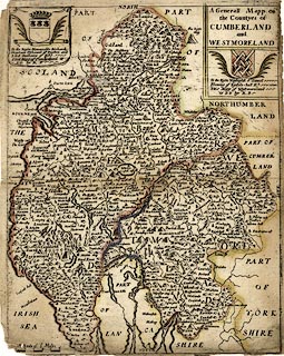
Map, hand coloured engraving, A Generall Mapp of the
Countyes of Cumberland and Westmoreland ie Westmorland,
scale about 4 miles to 1 inch, derived from Speed 1611, by
Richard Blome, engraved by Richard Palmer, published 1681.
Included in Speed's Maps Epitomiz'd or the Maps of the Counties of England. |
||

|
Blome 1681 | |
| map feature:- | plain cartouche & coat of arms & labelled borders (English) & up is N & scale line (incomplete) & sea plain & coast shaded & rivers & lakes & relief & hillocks & forests & parks & county & settlements | |
| inscription:- |
printed tile cartouche, upper right
A Generall Mapp of / the Countyes of / CUMBERLAND / and / WESTMORELAND |
|
| inscription:- |
printed upper right, below title
To the Right Worshipful Sr. Daniel / Ffleming of Rydale : hall Kt. / This Mapp of Westmoreland / is DD by RB coat of arms |
|
| inscription:- |
printed upper left
To the Right Honourable Richard / Grayham Viscount of Preston and / Lord Grahame of Eske / This Mapp of Cumberland is / DD by RB coat of arms |
|
| inscription:- |
printed above scale line
A Scale of 6 Miles |
|
| scale line:- | 6 miles = 37.6 mm (estimate) | |
| scale:- | 1 to 260000 ? (1 to 256810 from scale line wrongly assuming a statute mile) | |
| wxh, sheet:- | 20.5x25.5cm | |
| wxh, map:- | 196x248mm | |
|
|
notes | |