 Blome 1681

|

|
|
|
map type:- Blome 1681 |
|
|
|
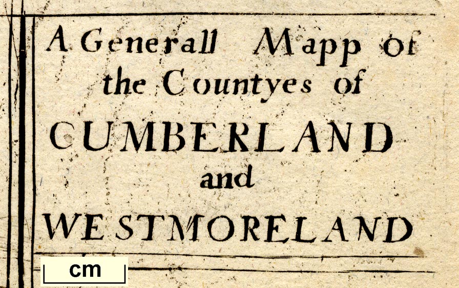
Generall Mapp of the Countyes of Cumberland and
Westmoreland, scale about 4 miles to 1 inch, derived from
Speed 1611, by Richard Blome, engraved by Richard Palmer,
?1673, re-engraved? and published 1681; published 1681-1735.
Published in 'Speed's Maps Epitomiz'd or the Maps of the Counties of England, Alphabetically placed. London, Printed Ann. Dom, 1681.' The atlas has a general map of England; the atlas size is 5 1/2 x 7 1/2 ins. The maps were engraved from 1667 to 1671. The map is said to be a crude reduction of Speed's map, it is believed to have been engraved at the same time as the 1673 map; it has the arms of Richard Grayham and Sir Daniel Fleming; the reverse is plain. Published in a second edition 'Speed's Maps Epitomiz'd ... London, Printed and Sold by Sam Lownes over against Exeter Exchange in the Strand. 1685.' Published in 'Cosmography and Geography, in Two Parts: the First, ... Being a Translation from ... Varenius. ... The Second Part, being a Geographical Description of all the World, ... The Third Impression, Illustrated with Maps. To which is added the County-Maps of England, drawn from those of Speed. London, Printed by Samuel Roycroft, for Richard Blome, dwelling near Clare' 1693. After Blome's death, 1705, the plates were owned by bookseller Thomas Taylor who used them 1715-18; and they were used again by Thomas Bakewell, 1750 (Skelton, but this disagrees with Chubb). Published in 'England Exactly Described Or a Guide to Travellers In a Compleat Sett of Mapps of all the County's of England being a map; for each County where every Town & Village in each County is Perticulerly Expressed with the Names and Limits of every Hundred &c. Very Usefull for all Gentlemen and Travellers being made fitt for the Pockett; Printed Coloured and Sold by Tho: Taylor at ye Golden Lyon in Fleetstreet where are Sold all Sorts of Mapps and fine French Dutch and Italian Prints.' 1715. Maps from the 1715 atlas were advertised singly at 2d each; the atlas size is 10 x 7 1/2 ins. Published in 'England Exactly Described Or a Guide to Travellers In a Compleat Sett of Mapps of All the Counties of England; being a Map for each County, Wherein every Towne and Village is Particularly Express'd with the Names and Limits of every Hundred, and the Roads and Distances in Measured Miles according to Mr. Ogilby's Survey. Very Usefull for Gentlemen and Travellers being made fit for the Pockett. Printed Coloured and Sold by Tho: Taylor ...' 1717. The map is unchanged from the 1715 edition; the atlas has a table of distances for the whole country. Published in 'England Exactly Described ... Sold by Tho: Bakewell, next ye Horn Tavern in Fleet Street.' about 1735. the map is unchanged from the 1715 edition; the map or atlas probably remained in print up to about 1750. |
||

|
Speed 1611 | |
|
(map example Dove Cottage : 2007.38.47)
|
||
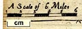
| map feature:- | plain cartouche & up is N & scale line (incomplete) & sea plain & coast shaded & rivers & lakes & relief & hillocks & woods & trees & forests & parks & county & settlements & roads & road distances | |
| inscription:- |
printed tile cartouche, upper right
A Generall Mapp of / the Countyes of / CUMBERLAND / and / WESTMORELAND |
|
| wxh, sheet (incomplete):- | 20x28.5cm | |
| scale line:- | 6 miles = 37.2 mm (estimate) | |
| scale:- | 1 to 260000 ? (1 to 259572 from scale line wrongly assuming a statute mile) | |
| scale line:- | 6 miles = 1 1/2 ins | |
| scale:- | 1 to 250000 ? | |
|
||
| references:- |
Blome, Richard: 1681: Speed's Maps Epitomiz'd: (London) Blome, Richard: 1685: Speed's Maps Epitomiz'd: Lownes, Sam (London) Blome, Richard: 1693: Cosmography and Geography: (London): part 3 : 1715 & 1716: England Exactly Described: Taylor, Thomas (London) : 1716 & 1735: England Exactly Described: Bakewell, Thomas (London) |
|
| sources:- |
Chubb 1927 (CX) Skelton 1970 Wordsworth Trust Collection Armitt Library Curwen 1918 |
|
| items seen (illustrated items in bold):- | ||
|
|
Armitt Library : ALMC2008.14.38 -- map -- Generall Mapp of the Countyes of Cumberland and Westmoreland | |
|
|
Carlisle Library : Map 5 -- map -- Generall Mapp of the Countyes of Cumberland and Westmoreland | |
|
|
Dove Cottage : 2007.38.47 -- map -- Generall Mapp of the Countyes of Cumberland and Westmoreland | |