 Blome 1681

|

|
|
|
item:- Dove Cottage : 2007.38.47 image:- © see bottom of page |
click to enlarge |
|
|
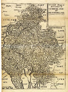
Map, uncoloured engraving, A Generall Mapp of the
Countyes of Cumberland and Westmoreland ie Westmorland,
scale about 4 miles to 1 inch, derived from Speed 1611, by
Richard Blome, engraved by Richard Palmer, published 1681,
but perhaps a later copy, 1715?
Included in Speed's Maps Epitomiz'd or the Maps of the Counties of England. The item is incomplete, the left edge missing. Dedications, with coats of arms have been removed from upper left and below the title cartouche; roads are added. |
||

|
Blome 1681 | |
| map feature:- | plain cartouche & labelled borders (English) & up is N & scale line (incomplete) & sea plain & coast shaded & rivers & lakes & relief & hillocks & woods & forests & parks & county & settlements & roads & road distances | |
| inscription:- |
printed tile cartouche, upper right
A Generall Mapp of / the Countyes of / CUMBERLAND / and / WESTMORELAND |
|
| scale line:- | 6 miles = 37.2 mm (estimate) | |
| scale:- | 1 to 260000 ? (1 to 259572 from scale line wrongly assuming a statute mile) | |
| wxh, sheet (incomplete):- | 20x28.5cm | |