 Blome 1681

|

|
|

|
back to object record | |
| Map Features | ||
|
|
||
|
title cartouche
plain cartouche map maker dedication coat of arms |
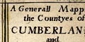
Printed in a plain title cartouche, upper right:- A Generall Mapp of the Countyes of CUMBERLAND and WESTMORELAND and below the title there is a coat of arms and dedication:- 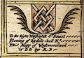
To the Right Worshipful Sr. Daniel Ffleming of Rydale:hall Kt. This Mapp of Westmoreland is DD by RB A further dedication with coat of arms upper left is:- 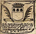
To the Right Honourable Richard Grayham Viscount of Preston and Lord Grahame of Eske This Mapp of Cumberland is DD by RB RB is Richard Blome. |
|
|
|
||
|
orientation
labelled borders up is N |
Printed in three of the four borders are:-
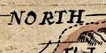
NORTH / EAST / SOUTH The map is printed with North at the top of the sheet. |
|
|
|
||
|
scale line
scale |
Printed above the scale line, lower left:-
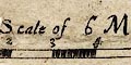
A Scale of 6 Miles chequered and labelled in miles. The 6 miles = 37.6 mm approximately, gives a scale 1 to 256810 wrongly assuming a statute mile. The map scale is about:- scale: 1 to 260000 4 miles to 1 inch |
|
|
|
||
|
sea area
sea plain |
The sea area is plain. Some sea areas are labelled,
eg:-
THE IRISH SEA Itune Bay |
|
|
|
||
|
coast line
coast shaded foreshore |
The coast line is emphasized by shading. Foreshore sands are outlined, with their own shading. |
|
|
|
||
|
rivers
bridges |
Rivers are drawn by wiggly line tapering upstream. Some rivers are labelled, eg:- Darwent flu [Derwent] Sput flu [Sprint] Can flu [Kent] Ituna flu / Eden flu [Eden] Beware that the abbreviation flu cannot be safely expanded; the abbreviation is also used in lake names. There are a few places where two lines are drawn crossing, but not interrupting, a stream. This symbol is used, not necessarily contemporarily, for bridges or waterfalls. 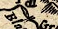
A few instances do appear to be bridges. It is possible to recognize, for example:- Ouse Bridge Newby Bridge [which does interrupt the stream] |
|
|
|
||
| lakes |
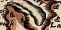
Lakes are drawn by an outline with shore shading. Some lakes are labelled:- Brodwater [Ennerdale Water] Ulles flu [Ullswater] W[in]ander mere flu Other lakes might be recognized, eg:- Bassenthwaite Lake Bleaberry Tarn [its size exaggerated] Brothers Water (?) Burnmoor Tarn (perhaps) Buttermere lake Coniston Water Crummock Water Derwent Water Esthwaite Water (?) Loweswater lake Thirlmere Wast Water An island in Derwent Water is labelled:- Darwen Iland |
|
|
|
||
|
relief
hillocks |
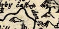
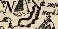
Relief is indicated by hillocks, shaded, unusually, to the west. Mostly these symbols are small, and are scattered liberally. The Solway coast is less hilly. A few hills are labelled, eg:- Skiddow hill and some hills are drawn large, and labelled, eg:- 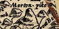
Morton pike The Spye cragg |
|
|
|
||
|
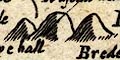
forests
trees |
Forest areas are indicated by groups of tree symbols,
labelled, eg:-
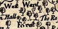
West Ward Forest Inglewood Forest |
|
|
|
||
| parks |
A few parks are drawn by a ring of fence palings,
labelled by name or house name, eg;-
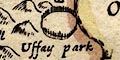
Uffay park Graystock cast Other parks might be labelled, though not marked, eg:- Brigster park |
|
|
|
||
| county |
County boundaries are a dashed line which is sometimes carried on alongside a boundary feature such as a river. The two county areas of the map are labelled:- WESTMORELAND CUMBERLAND if you can find the letters spread in spare spaces on the map. The boundaries are emphasized by a tint on the inner side of each boundary, unfortunately faded, they seem to have been: Cumberland red, Westmorland blue, Lancashire yellow, Northumberland green, Yorkshire green; and notice the area to the east labelled:- PART OF CUMBERLAND Adjacent counties are labelled, eg:- PART OF YORK SHIRE PART OF NORTHUMBER LAND |
|
|
|
||
| settlements |
Settlements are marked by a circle, with added elements,
further slightly differentiated by style of labelling. All
the engraving on this map is poor, including the lettering;
and its size, weight and aspect are not reliable guidelines
to the importance of a place.
|
|
|
cities
towns |
circle, buildings, spire with a cross; labelled in italic
lowercase text, eg:-
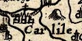
Carlile 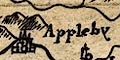
Appleby Penreth |
|
|
villages
hamlets |
circle, tower; labelled in italic lowercase text,
eg:-
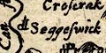
Seggeswick Kendall Shapp Croke |
|
| hamlet |
circle; labelled in italic lowercase text, eg:-
Stapleton Deepdale There are very few places marked in this way and I suspect it might just be an error. |
|
|
|
||
| miscellaneous | ||
|
|
||
|
antiquities
roman wall |
Hadrian's Wall is drawn by a double line with cross lines, an attempt to suggest a stone wall, from Boulnesse [Bowness] through Carlile, then north and east into Northumberland. |
|
|
|
||
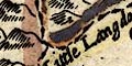
| stones |
By the county boundary south of Thirlmere are drawn two
stones labelled:-
Dunbalrase [s]tones A single stone is labelled:- 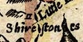
Shire stones at the head of Langdale. |
|
|
|
||
| beacons |
South of Great Asby is a hill with a post topped by a
?circle, labelled:-
The Beacon A hill north of Isle [Isel] has a post with three cross bars, labelled:- 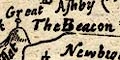
Mewtoo Beacon |
|
|
|
||
| mines |
In the hills by Caldbeck is labelled:-
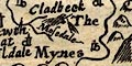
The Mynes |
|
Lakes Guides menu.