 Wallis 1810

|

|
|
|
map type:- Wallis 1810 |
|
|
|
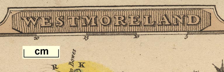
Map, Westmoreland, scale about 19 miles to 1 inch, and
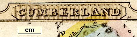
Cumberland, scale about 16 miles to 1 inch, by James Wallis,
77 Berwick Street, Soho, London, 1810; published 1810-36.
Published in 'WALLIS'S New Pocket Edition of the ENGLISH COUNTIES or Travellers Companion in which are carefully laid Down all the DIRECT & CROSS ROADS, CITIES, Townes, Villages, Parks, Seats, and Rivers. with a General Map of England & Wales / London Published by J. WALLIS Engraver, Berwick St. Soho. and Sold by DAVIES & ELDRIDGE Exeter.' 1810. The atlas has title page, address to the public, contents list and 54 maps; its size is 10x14.5cm. The maps do not have plate numbers. Published in a 2nd edn, 1814. The 2nd edn maps have plate numbers. Published in 'Sportsmans Almanack' by P Martin, 198 Oxford Street, London, 1819. Published, plates retouched, in 'Lewis's New Traveller's Guide, or a Pocket Edition of the English Counties, Containing all the Direct & Cross Roads in England & Wales. With the distance of each principal place from London. London. Publish'd by W. Lewis, No.21, Finch Lane, Cornhill.' 1819. The map is altered, cleaned up - hill hachures removed, lake shading reduced, roads re-engraved and emphasised, imprints changed; there is a page of text about the county. Published in another edition 'Lewis's New Traveller's Guide, And Panorama of England and Wales. Containing Forty-four Superior maps. London, 1835'. |
||
|
(map example JandMN (63))
|
||
| map feature:- | title cartouche (shaded) & table of symbols & compass rose & up is E & scale line & lat and long scales & table of symbols & sea plain & coast line & rivers & lakes & parks & county & settlements & roads & turnpike roads & post roads & canals | |
| longitude, Kendal:- | 2d 47m W | |
| inscription:- |
printed title cartuoche, upper border
WESTMORELAND |
|
| inscription:- |
printed bottom
London Publish'd by W. Lewis, 21, Finch Lane. |
|
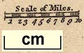
| scale line:- | 10 miles = 13.2 mm | |
| scale:- | 1 to 1200000 ? (1 to 1219200 from scale line, assuming a statute mile) | |
| wxh, sheet:- | 11.5x14.5cm | |
| wxh, map:- | 93x132mm | |
|
||

|
||
|
||
| references:- |
Wallis, James: 1810: Wallis's New Pocket Edition of the
English Counties: (London) : 1819: Lewis's New Traveller's Guide ...: Lewis (London) : 1819: Sportsmans Almanack: Martin, P (London) : 1835 & 1836: Lewis's New Traveller's Guide & Panorama of England and Wales: Lewis (London) |
|
| sources:- |
Chubb 1927 (CCCXLIV) JandMN Collection Wordsworth Trust Collection Armitt Library Kendal Library Maps Carlisle Library Maps |
|
| items seen (illustrated items in bold):- | ||

|
Armitt Library : ALMC2008.14.111 -- road map -- Westmoreland | |
|
|
Armitt Library : ALMC2008.14.112 -- road map -- Westmoreland | |
|
|
Carlisle Library : Map 143 -- road map -- Cumberland | |
|
|
Carlisle Library : Map 181 -- road map -- Westmoreland | |
|
|
Dove Cottage : 2007.38.52 -- road map -- Westmoreland | |
|
|
Dove Cottage : 2009.81.10 -- road map -- Cumberland | |
|
|
JandMN (63) -- road map -- Westmoreland | |
|
|
JandMN (92) -- road map -- Cumberland | |
|
|
JandMN (330) -- road map -- Westmoreland | |
|
|
Kendal Library : Map 67 -- road map -- Westmoreland | |