 Wallis 1810

|

|
|
|
item:- Armitt Library : ALMC2008.14.111 image:- © see bottom of page |
click to enlarge |
|
|
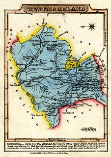
Road map, hand coloured engraving, Westmoreland, scale
about 19 miles to 1 inch, by James Wallis, 1810, published
by W Lewis, 21 Finch Lane, London, 1819.
Notice the labels in the border scales - at the side of the map 'Long. W. fr. Lond.', the longitude scale; at the bottom 'Long. W. fr London', on the latitude scale. Included in Lewis's, New Traveller's Guide, or a Pocket Edition of the English Counties. The map is accompanied by a sheet, 2 pages, of descripive text about the county. |
||

|
Wallis 1810 | |
| map feature:- | plain cartouche & table of symbols & compass rose & up is E & scale line & lat and long scales & coast shaded & rivers & lakes & relief & hill hachuring & parks & county & settlements & roads & turnpike roads & post roads & distances from London & canals & electoral data | |
| inscription:- |
printed title cartouche, upper border
WESTMORELAND |
|
| inscription:- |
printed bottom
London Publish'd by W. Lewis, 21, Finch Lane. |
|
| scale line:- | 10 miles = 13.3 mm | |
| longitude, Kendal:- | 2d 47m W | |
| scale:- | 1 to 1200000 ? (1 to 1210033 from scale line, assuming a statute mile) | |
| wxh, sheet:- | 12x15.5cm | |
| wxh, plate:- | 106x143mm | |
| wxh, map:- | 93x132mm | |