 Wallis 1810

|

|
|
|
item:- JandMN (92) image:- © see bottom of page |
click to enlarge |
|
|
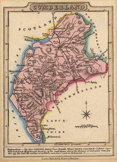
Road map, hand coloured engraving, Cumberland, scale
about 16 miles to 1 inch, by James Wallis, published by W
Lewis, Finch Lane, London, 1819.
Perhaps the version in Lewis's New Traveller's Guide, 1819. |
||

|
Wallis 1810 | |
| map feature:- | plain cartouche & table of symbols & compass rose & up is N & scale line & lat and long scales & coast tinted & rivers & lakes & relief & hill hachuring & parks & county & settlements & roads | |
| inscription:- |
printed title cartouche, upper centre
CUMBERLAND |
|
| inscription:- |
printed bottom centre
London Publish'd by W. Lewis Finch Lane. |
|
| inscription:- |
printed with scale line
Scale of Miles |
|
| scale line:- | 12 miles = 19.1 mm | |
| scale:- | 1 to 1000000 ? (1 to1011106 from scale line) | |
| wxh, map:- | 95x133mm | |