 Stukeley 1723

|

|
|
|
map type:- Stukeley 1723 |
|
|
|
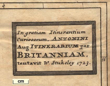
Road map, Itinerarium per Britanniam, the Antonine
Itineraries through Britain, scale about 55 miles to 1 inch,
plotted by William Stukeley, 1723, published London, 1724.
Published in 'Itinerarium Curiosum. Or, an account of the antiquity and remarkable curiositys in nature or art ... By William Stukeley, 1724.' Published in 'A New Description of England and Wales, ... By Herman Moll, Geographer. London: ... M.DCC.XXIV.' ie 1724. The style of the engraving, particulary the title cartouche, is that of Herman Moll's atlas. Moll's preface says of Stukeley that '... to encourage this Design, [he] presented us with it ...' Published in 'A Set of Fifty New and Correct Maps Of England and Wales, &c. ... All, except two, composed and done by Herman Moll, ... 1724.' Stukeley's being one of the two. This atlas has plate numbers. |
||
|
(road map example HMCMS:FA2001.171)
|
||
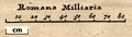
| map feature:- | title cartouche & picture frame cartouche & lat and long scales & scale line & sea plain & coast shaded & settlements & roman roads | |
| scale line:- | 80 roman miles = 52.4 mm | |
| inscription:- |
printed title cartouche
In gratiam Itinerantium / Curiosorum, ANTONINI / Aug. ITINERARIUM per / BRITANNIAM. / tentavit W. Stukeley 1723. |
|
| wxh, sheet:- | 28x33cm | |
| wxh, map:- | 245x272mm | |
| scale:- | 1 to 2400000 ? (estimated from lat long scales) | |
|
||
| references:- |
Rivet, A L F & Smith, Colin: 1981: Place-Names of Roman
Britain: Batsford:: ISBN 0 7134 2077 4 Horsley, John: 1723: Britannia Romana: (London) Stukeley, William: 1776 (2nd edn): Itinerarium Curiosum: (London) |
|
| sources:- |
Hodson 1984 HMCMS Map Collection Carlisle Library Maps |
|
| items seen (illustrated items in bold):- | ||

|
Carlisle Library : Map 293 -- road map -- Antonine Itineraries through Britain | |
|
|
Hampshire Museums : FA2001.171 -- road map -- Antonine Itineraries through Britain | |