 Stukeley 1723

|

|
|
|
item:- Carlisle Library : Map 293 image:- © Carlisle Library |
click to enlarge |
|
|
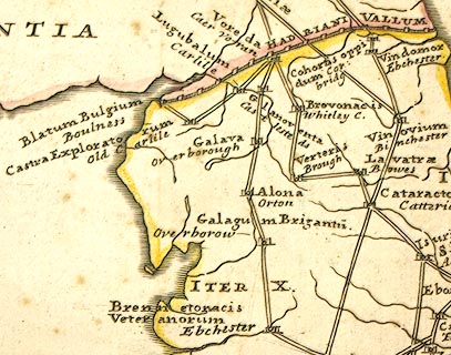
Road map, uncoloured engraving, the Antonine Itineraries
through Britain, scale about 55 miles to 1 inch, plotted by
William Stukeley, 1723, published London, 1724.
The map was published in Itinerarium Curiosum by William Stukeley, and in A New Description of England and Wales by Herman Moll, both 1724. |
||

|
Stukeley 1723 | |
| map feature:- | picture frame cartouche & up is N & lat and long scales & scale line & sea plain & coast shaded & rivers & settlements (roman) & roman roads & roman sites | |
| inscription:- |
printed title cartouche
In gratiam Itinerantium / Curiosorum, ANTONINI / Aug. ITINERARIUM per / BRITANNIAM. / tentavit W. Stukeley 1723. |
|
| scale line:- | 80 roman miles = 52.1 mm | |
| wxh, sheet:- | 28x31.5cm | |
| wxh, map:- | 245x273mm | |
| scale:- | 1 to 2400000 ? (estimated from lat long scales) | |
| scale:- | 1 to 3500000 ? (from town positions using DISTAB.exe) | |
|
image:- © Carlisle Library |
|
|