 Stanford's Geological Atlas

|

|
|
|
map type:- Stanford 1904 |
|
|
|
Geological maps, Stanford's Geological Atlas of Great
Britain and Ireland, by Horace B Woodward, published by
Edward Stanford, 12-14 Long Acre, London, 3rd edn 1914.
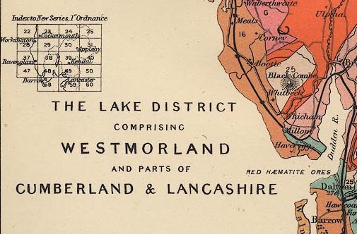
The book has - title page; preface by H B Woodward, Croydon, Surrey, 1913; contents, list of sections, views, geological maps, plates of fossils; table of strata and list of characteristic fossils; descriptions of geology of countries and individual counties; descriptions of the geology seen on railway journeys; list of fossils; index; 64 colour printed geological maps of Great Britain and the counties; plates of fossils. In the colour printed geological maps the areas of solid geology are coloured and labelled with a number that refers to a table of strata near the front of the atlas. An index map indicates which New Series 1 inch OS geological maps are relevant to the county. The maps relevant to The Lakes area are:- North Cumberland, scale about 7 miles to 1 inch, and Isle of Man, scale about 6 miles to 1 inch. Lake District, ie Westmorland, and parts of Cumberland and Lancashire, scale about 7 miles to 1 inch. And surrounding areas:- West Yorkshire and Lancashire, scale about 10.5 miles to 1 inch. Durham, scale about 6 miles to 1 inch. Northumberland, scale about 8 miles to 1 inch. And the general map:- Geological Map of Great Britain, scale about 95 miles to 1 inch. |
||
| inscription:- |
printed title page
STANFORD'S / GEOLOGICAL ATLAS / OF GREAT BRITAIN / AND IRELAND / WITH PLATES OF CHARACTERISTIC FOSSILS / PRECEDED BY DESCRIPTIONS OF THE GEOLOGICAL / STRUCTURE OF GREAT BRITAIN AND IRELAND / AND THEIR COUNTIES; OF THE CHANNEL / ISLANDS; AND OF THE FEATURES / OBSERVABLE ALONG THE / PRINCIPAL LINES OF / RAILWAY / BY HORACE B. WOODWARD, F.R.S., F.G.S. / THIRD EDITION / LONDON : EDWARD STANFORD, LTD. / 12, 13, & 14, LONG ACRE, W.C. / 1914 |
|
| wxh:- | 14x20cm | |
| sources:- |
HMCMS Map Collection |
|
| items seen (illustrated items in bold):- | ||

|
Hampshire Museums : FA2002.654 -- atlas -- Stanford's Geological Atlas | |
|
|
Hampshire Museums : FA2002.654.1 -- geological map -- Geological Map of Great Britain -- Stanford's Geological Atlas | |
|
|
Hampshire Museums : FA2002.654.7 -- geological map -- North Cumberland and Isle of Man -- Stanford's Geological Atlas | |
|
|
Hampshire Museums : FA2002.654.8 -- geological map -- Lake District -- Stanford's Geological Atlas | |
|
|
Hampshire Museums : FA2002.654.12 -- geological map -- Durham -- Stanford's Geological Atlas | |
|
|
Hampshire Museums : FA2002.654.18 -- geological map -- West Yorkshire and Lancashire -- Stanford's Geological Atlas | |
|
|
Hampshire Museums : FA2002.654.23 -- geological map -- Northumberland -- Stanford's Geological Atlas | |