 Stanford 1904

|

|
|
|
item:- Hampshire Museums : FA2002.654.1 image:- © see bottom of page |
click to enlarge |
|
|
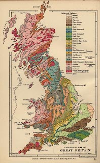
Geological map, colour printed, Geological Map of Great
Britain, scale about 95 miles to 1 inch, in Stanford's
Geological Atlas of Great Britain and Ireland, by Horace B
Woodward, published by Edward Stanford, 12-14 Long Acre,
London, 3rd edn 1914.
|
||

|
Stanford 1904 | |
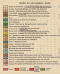
| map feature:- | scale line & lat and long scales & stratigraphical column & sea plain & coast line & geology | |
| inscription:- |
printed lower right
GEOLOGICAL MAP OF / GREAT BRITAIN |
|
| inscription:- |
printed bottom
Stanford's Geographicl. Estabt. London / London : Edward Stanford, Ltd., 12, 13, & 14, Long Acre, W.C. |
|
| scale line:- | 100 miles = 26.8 mm | |
| wxh, sheet:- | 12x18.5cm | |
| wxh, map:- | 100x166mm (but extends beyond borders) | |
| scale:- | 1 to 6000000 ? (1 6005015 to from scale line) | |
|
||
|
|
notes | |