 Stanford 1904

|

|
|

|
back to object record | |
| Atlas | ||
|
The atlas has:- title page; preface by H B Woodward,
Croydon, Surrey, 1913; contents, list of sections, views,
geological maps, plates of fossils; table of strata and list
of characteristic fossils; descriptions of geology of
countries and individual counties; descriptions of the
geology seen on railway journeys; list of fossils; index; 64
colour printed geological maps of Great Britain and the
counties (some maps are documented separately); plates of
fossils.
|
||
|
Some of these notes are biased toward a Hampshire interest;
the essay was first written for Hampshire Museums.
|
||
|
Title page:-
|
||
|
STANFORD'S GEOLOGICAL ATLAS OF GREAT BRITAIN AND IRELAND
WITH PLATES OF CHARACTERISTIC FOSSILS PRECEDED BY
DESCRIPTIONS OF THE GEOLOGICAL STRUCTURE OF GREAT BRITAIN
AND IRELAND AND THEIR COUNTIES; OF THE CHANNEL ISLANDS; AND
OF THE FEATURES OBSERVABLE ALONG THE PRINCIPAL LINES OF
RAILWAY BY HORACE B. WOODWARD, F.R.S., F.G.S.
|
||
|
THIRD EDITION LONDON: EDWARD STANFORD, LTD. 12, 13, & 14,
LONG ACRE, W.C. 1914
|
||
|
The preface explains the sources of information for the
geological descriptions and maps, pp.v-vi:-
|
||
|
PREFACE
|
||
|
THE first edition of Stanford's Geological Atlas ... was
published in 1904. It was based in general plan, and
especially in regard to the maps, on Reynold's Geological
Atlas ... 1860 and 1889. The text, however, was entirely
re-written, ... descriptions of the geological features
observable along the main lines of railway were added.
|
||
|
A few of the original text-illustrations were retained;
others were borrowed from Sir Andrew C. Ramsay's Physical
Geology and Geography of Great Britain. The figures of
fossils were reproduced chiefly from Lowry's Tabular View of
Characteristic British Fossils; others were taken from the
Chart of Fossil Crustacea, arranged by J. W. Salter and Dr.
Henry Woodward, and a few from Ramsay's Physical Geology.
|
||
|
The maps in the original Atlas were based to a large extent
on those of the Geological Survey, and they have been
revised, as far as the scale has permitted, from the later
published maps of that institution.
|
||
|
...
|
||
|
The present edition has been amplified ... [little of
significance to Hampshire].
|
||
|
...
|
||
|
HORACE B. WOODWARD. / CROYDON. / September 1913.
|
||
| Geology | ||
|
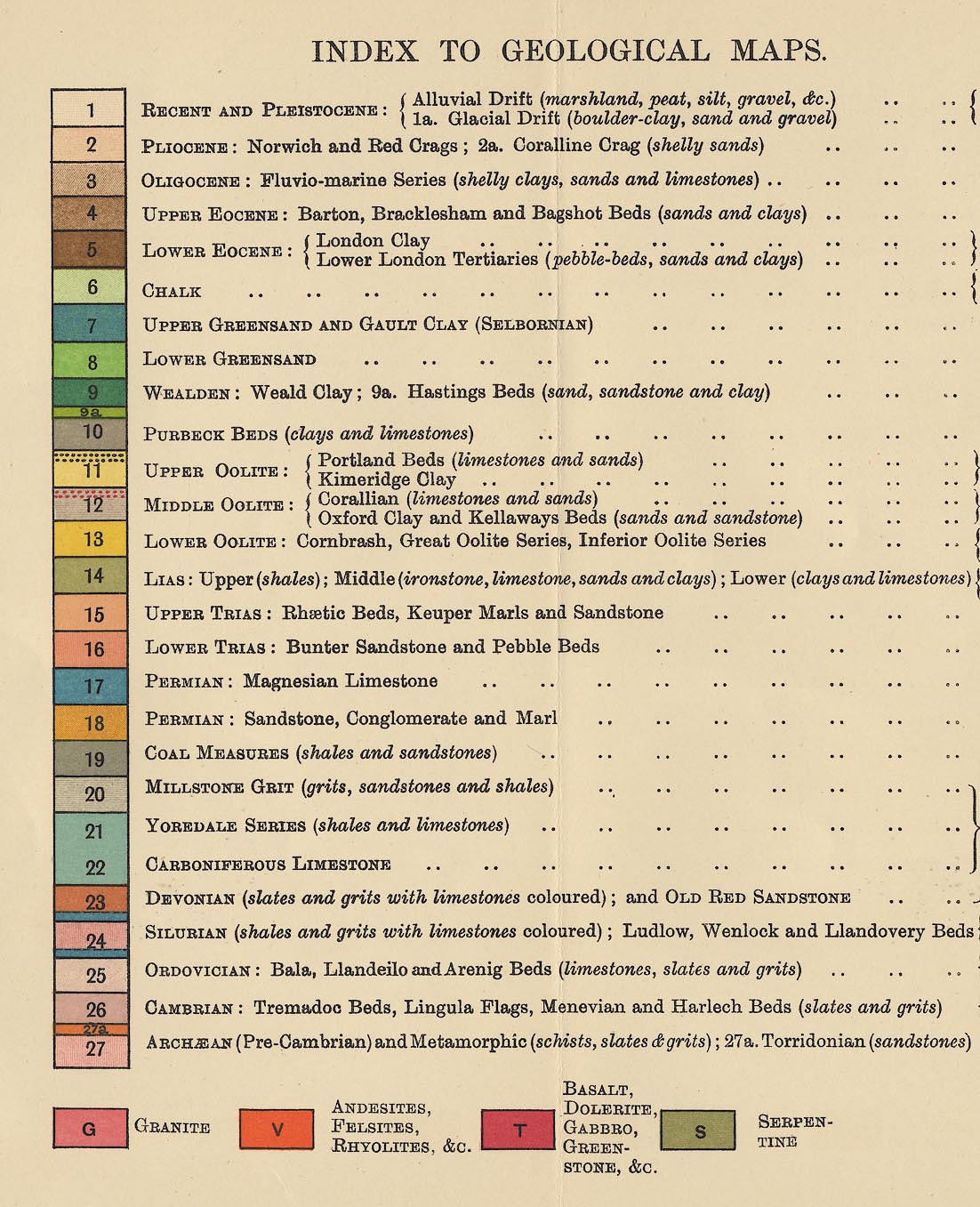
Facing page 1 there is a table of strata, a key for the
geological maps, and list of their fossils. Each stratum has
a coloured rectangle labelled with a number (colours can
only be described roughly). The strata that concern The
Lakes are 14 to 25 and intrusives G, V, and T:-
|
||
|
||
|
14 LIAS: Upper (shales); Middle (ironstone, limestone, sands and clays); Lower (clays and limestones) 15 UPPER TRIAS: Rhaetic Beds, Keuper Marls and Sandstone 16 LOWER TRIAS: Bunter Sandstone and Pebble Beds 18 PERMIAN: Sandstone, Conglomerate and Marl 19 COAL MEASURES (shales and sandstone) 20 MILLSTONE GRIT (grits, sandstones and shales) 21 YOREDALE SERIES (shales and limestone) 22 CARBONIFEROUS LIMESTONE 23 DEVONIAN (slates and grits with limestones coloured); and OLD RED SANDSTONE 24 SILURIAN (shales and grits with limstones coloured); Ludlow, Wenlock and Llandovery Beds 25 ORDOVICIAN: Bala, Llamdeilo and Arenig Beds (limestones, slates and grits) G GRANITE V ANDESITES, FELSITES, RHYOLITES, &C. T BASALT, DOLERITE, GABBRO, GREENSTONE, &C. |
||
|
INDEX TO GEOLOGICAL MAPS. / PRINCIPAL ORGANIC REMAINS OR
FOSSILS.
|
||
|
In the text on the Geological Structure of Great Britain
there is a tabulation of the:-
|
||
|
FORMATIONS OF GREAT BRITAIN
|
||
|
SEDIMENTARY AND METAMORPHIC ROCKS
|
||
|
These are listed with their thicknesses in feet:-
|
||
|
Then a list of:-
|
||
|
IGNEOUS ROCKS
|
||
Lakes Guides menu.